SNOW - SERIOUSLY ITS ALMOST MAY!
"Good Grief" - Its Almost May - What Is This?
NWS Winter Storm Warnings & Watches In Effect.
(As Of 4:30 PM MDT Friday).
Valid At 4:15 PM MDT Friday.
Valid At 4:23 PM MDT Friday.
Valid At Noon MDT Saturday.
Simply put I think that the computer forecast models are out to lunch on this storm. Meaning that they are still all over the place with the track and timing of the strong cold closed upper level low that will settle in over New Mexico tonight into Sunday. Its model mayhem for sure and that just makes forecasting what its effects on the state and local area will be even more difficult. After 40 years of tracking upper level storms via hand analysis and model forecasting this one is proving to be quite the bear to handle. Given that its almost May and that this storm is very cold for this time of the year and tracking this far south also clouds the models forecasts in my humble opinion. So going with my gut feeling and lifelong experience of watching the weather I still am leaning towards the Canadian (GEM's) model forecasts...which is the coldest and furthest south of the model forecasts. Bang my head against the wall Charlie Brown..."Good Grief".
Valid At 4 PM MDT This Afternoon.
There is almost a 60-degree temperature difference between Northern New Mexico and Southeastern New Mexico and West Texas as of 4 PM MDT this afternoon. And that's just nuts!
U.S. Temperature Anomaly Forecast.
Valid At 6 PM MDT Saturday.
Mixing model forecasts isn't what I like to do. Since none of them agree I am to try and show what I think will happen this weekend. And if Mother Nature makes a fool out of me...it won't be the first time nor the last. As I mentioned in yesterday afternoon's blog how warm we get here in SE NM tomorrow will depend upon the timing of the arrival of the strong cold front. If it blasts through the local area tonight into early Saturday morning then we may only see high temps in the 40's Saturday afternoon. On the other hand if it slows down and doesn't arrive until later in the afternoon we will climb up into the 70's then fall like a rock afterwards when it arrives. Anyway temperatures across Eastern and Southeastern New Mexico Saturday afternoon could easily be some 20 to 40 degrees below normal!
Again How Cold - How Soon On Saturday?
Valid At 6 PM MDT Saturday.
Valid At 6 AM MDT Sunday.
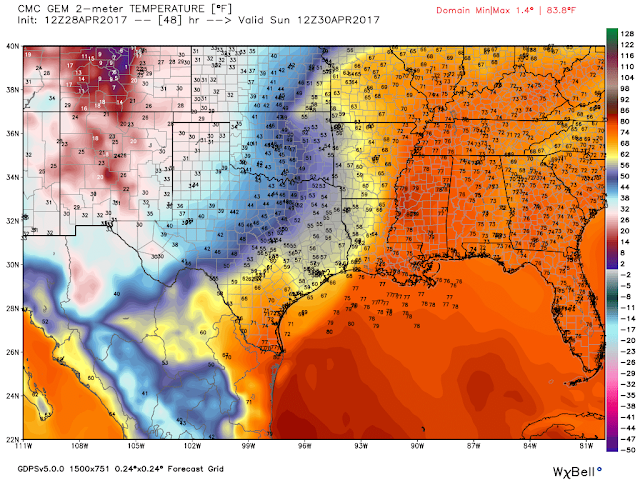
In keeping with the "coldest and snowiest scenario" the Canadian model just gets really crazy cold tomorrow...depicted above. NWS Midland is leaning somewhat in this direction with this Special Weather Statement issued earlier today concerning a local area freeze. My feeling is that come Sunday morning most of the local area will drop down to freezing and below. A hard freeze seems plausible in some locals too. This after days on end of high temps in the 90's since February. I recorded a high temp of 90ºF here at our home in Carlsbad on February 11th. 90-degree afternoon high temps here in SE NM have been more common than overnight lows of freezing since February...weird.
The Puzzling Million Dollar Question - How Much Snow & Where?
Valid At 6 PM MDT Sunday.
Valid At 6 PM MDT Sunday.
WPC Storm Total Snowfall Forecast.
(Worst Case Scenario Forecast).
Valid At 6 AM MDT Monday.
Canadian (GEM) Storm Total Snowfall Forecast.
Valid At 6 PM MDT Sunday.
U.S. GFS Storm Total Snowfall Forecast.
Valid At 6 PM MDT Sunday.
WRF- NAM Storm Total Snowfall Forecast.
Valid At 6 PM MDT Sunday.
NAM Storm Total Snowfall Forecast.
Valid At 6 PM MDT Sunday.
NWS NDFD Storm Total Rainfall Forecast.
Valid At 6 PM MDT Sunday.
Do I Sound Sarcastic?
Charlie Brown thinks so...and that's ok. Mother Nature isn't playing nice so there!
The Truth Is Stranger Than Fiction!


Comments
Post a Comment
Your comments, questions, and feedback on this post/web page are welcome.