Posts

Showing posts from December, 2017

Jack Frost Rings In The New Year!

Image
Visible Satellite Image. Snapshot Taken At 9:57 AM MST This New Years Eve. Arctic air surged back westward into the Pecos Valley and the rest of Southeastern New Mexico overnight into this morning. Low clouds and freezing fog with pockets of freezing drizzle also covering the area as indicated above in this visible satellite image. Much Of The Nation East Of The Rockies In The Deep Freeze. Notice how many states and counties that are under a Wind Chill Advisory (light blue shades) and Wind Chill Warnings (light purple shades) as of 9 AM MST this morning. Parts of Southeastern New Mexico including Eddy and Lea Counties are under a Winter Weather Advisory this afternoon into New Years Day morning. This also includes much of West Texas eastward to the Northeastern Texas. Areas of freezing fog, light freezing drizzle, light freezing rain, light sleet, and light snow will be possible here in Southeastern New Mexico and West Texas. NWS MesoWest Reported Low Temper...

Warming Up Saturday But Turning Much Colder Sunday.

Image
Current Temperatures At 3 PM MST. U.S. Temps & Wind Chill At 3 PM MST. Temperatures across the Yukon of far Northwestern Canada as of 3 PM MST this Friday afternoon and ranging from -30ĀŗF to -42ĀŗF . Wind chill values across Northwestern Canada from the U.S. border northward are ranging from -30ĀŗF to -51ĀŗF . This is the long awaited arctic air mass that is already moving into the northern plains this afternoon. This will be the source of our cold New Years weather locally. Fear not this air mass will not be anywhere near that cold by the time it arrives here.  Cities Circled Are In Danger Of Breaking Their Daily Low Maximum Temperatures. Saturday. Sunday. New Years Day. Arctic Front Arrives Saturday Afternoon. NWS NDFD Forecast High Temperatures & Temperature Anamolies. Saturday. Saturday afternoon will be interesting as the first surge of the modified arctic air mass arrives locally. Current forec...

Colder Tonight Into Wednesday With A Chance Of Light Freezing Drizzle.

Image
10 AM MST Temps & Wind Chills. Surface Cold Front At 5 AM MST This Morning. Arctic air has moved into Northeastern New Mexico and the Texas Panhandle this morning. The cold front had sagged south into Southeastern New Mexico as of sunrise. As of 10 AM MST the temperature in Clayton was 10ĀŗF with a wind chill of -3ĀŗF. Amarillo was reporting a temp of 13ĀŗF with a wind chill of -3ĀŗF. Cannon Air Force Base at Clovis was reporting a temp of 26ĀŗF and a wind chill of 15ĀŗF. Low clouds were reported at all three locations. Meanwhile it was 36ĀŗF in Roswell and Hobbs and 47ĀŗF in Carlsbad .   NWS NDFD Forecast High Temperatures & Temperature Anomalies. Today. The colder air associated with the front is forecast to mix out of Southeastern New Mexico this afternoon with forecast highs in the low 60's. This colder airmass will then work its way back into the area tonight sticking around through Thursday morning. Wednesday. ...

Cold Front Approaching - No White Christmas For SE NM This Year!

Image
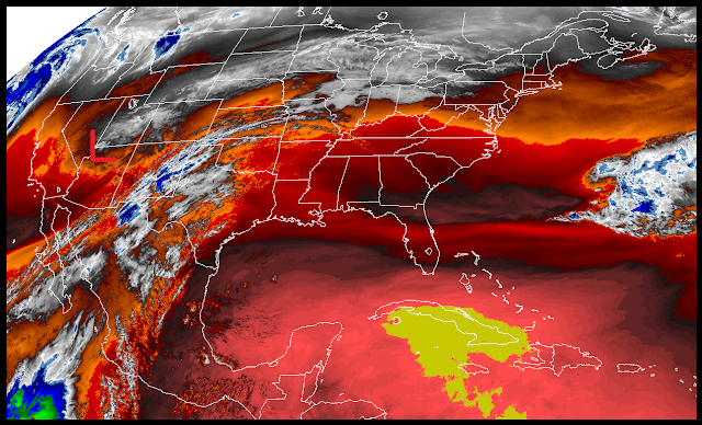
RAMMB/CIRA Lower Level Water Vapor Satellite Image. Valid At 11:07 AM MST This Morning. At noon today our next winter storm was located over far northwestern Arizona and continues sinking slowly southward.  Surface Map Forecast. Valid At 5 PM MST This Afternoon. Meanwhile at the surface a Pacific cold front was moving eastward through the western part of New Mexico while a modified arctic cold front was entering northeastern New Mexico headed south. These two cold fronts will merge and sweep eastward and southward out of southeastern New Mexico late tonight into early Friday morning. Temperatures & Wind Chill Values At Noon MST Today. Courtesy Of NWS MesoWest. Courtesy Of Oklahoma MesoNet. Courtesy Of Oklahoma MesoNet. Our long awaited change to colder weather will commence locally tonight with a second cold front invading the Eastern Plains Sunday.   Canadian (GEM) 500 MB Forecasts. Valid At 5 AM MST This Morn...

Current National Weather Service Watches/Warnings In Effect.

New Mexico

Chaves County Plains & Mtn's

Eddy County

Culberson County

Lea County

Lincoln County

Otero County

Current US Temps

Current US Wind Chill/Heat Index Temperatures

WPC 7-Day Precipitation Forecast

Roswell Live EarthCam

Ruidoso Live Webcam

Cloudcroft Live Webcam

NWS Midland 3-Day Precipitation Forecast

NWS Midland 3-Precipitation Chances

New Mexico 3-Day Precipitation Forecast

New Mexico Precipitation Chances

NWS El Paso 3-Day Precipitation Forecast

NWS El Paso Precipitation Chances

New Mexico 3-Day Snowfall Forecast

New Mexico Snowfall Chances

NWS El Paso 3-Day Snowfall Forecast

NWS El Paso Snowfall Chances

US 24-Hour Precipitation Forecast

US 3-Day Precipitation Forecast

US 24-Hour Snowfall Forecast

US 3-Day Snowfall Forecast