

Coolest Morning Of The Fall Season - Local YTD Rainfall Update.

Capitan Mountain WNW Of Roswell, NM At Sunset 9-22-2018.
Coolest Morning Since May 5th.
(Valid At 6 AM MDT Sunday, Sept 23rd, 2018).


(As Of 10 AM MDT).

Locally we had our coolest morning of this fall season this morning. Our lows once again dipped down into the 50's across the Southeastern Plains. The mountains saw lows in the 30's and 40's.
A few of the colder readings reported include:
A Personal Weather Station (PWS) In Cloudcroft(8,698') 31º
A Personal Weather Station (PWS) West Of Mayhill (7,241') 33º
A Personal Weather Station In 16 Springs Canyon (7,376') 34º
A Personal Weather Station In Timberon (7,001') 37º
Smokey Bear Raws In Ruidoso (7,090') 39º

Evening Twilight Between Roswell And Ruidoso Sunday.
2.1 NNW Downtown Carlsbad Temperature Graph.

Here at our home in northwest Carlsbad we dipped down to 52º this morning. This is the coolest low temperature since May 5th when we recorded a low of 51º. The Carlsbad Airport ASOS reported a low temperature this morning of 51º which is their coolest morning low since May 5th when a low over 48º was noted. This is the time of the year when we see cool mornings lows but our afternoon highs are still fairly warm.
Selected Local Average High/Low Temps For Sept 23rd.
(Long Term Averages: 1893 - 2017).
Roswell 84º - 54º
Artesia 84º - 54º
Carlsbad 85º - 58º
Hobbs 82º - 56º
Tatum 81º - 52º
Ruidoso 73º - 39º
Cloudcroft 64º - 41º

Moonrise Near Tinne West Of Roswell Sunday.
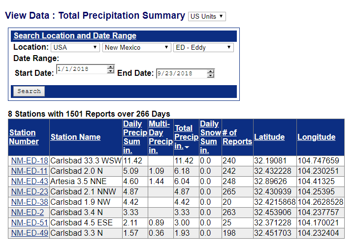
(January 1st - September 22nd, 2018).


My Greatest 24-Hour Total So Far This Year - .70" On Sept 6th.
These graphics are somewhat misleading in that locally they show more rainfall to have fallen than has been measured in some spots. A case in point is here at our home in northwestern Carlsbad. So far for September I've recorded 1.79" which is slightly above the Carlsbad Climate Co-Op Stations long term average of 1.67". However for the year I've only managed to measure 4.87" in our rain gague. Which compared to the long term average to date for the Carlsbad Climate Co-Op Station (10.37") is 5.50" below average to date.
Much of New Mexico had average to above summer monsoon rainfall but this isn't the case locally. The Carlsbad Climate Co-Op Station has measured 1.89" so far this month compared to an average to date of 1.67". This brings the station total for the year to 6.98" compared with the long term average to date of 10.37". That station located 6 miles southeast of my station has had 2.11" more rainfall than my gauge but is still some 3.39" below average for the year so far.
Roswell is pretty much in the same boat. The Roswell Industrial Air Center ASOS has measured 1.05" for the month compared to a long term average to date of 1.21". This brings their year-to-date total to 5.09" compared to a long term average to date of 10.14".
September 2018.


2018 Year-To-Date.
(January 1st - Sept 22nd).


To date 2018 is going down for the most part locally as being a drier than normal year. Even in the mountains where some the wettest reporting CoCoraHS Stations have had 15" to 23" of rainfall so far this year.
(September 23rd).

The Truth Is Stranger Than Fiction!


.png)


Comments
Post a Comment
Your comments, questions, and feedback on this post/web page are welcome.