Wet Storm Approaching - Rain, Windy, Colder, And Snow In The Mountains.
11-16-2019
A little bit of color left in the trees in the lower Penascio River Valley of the eastern foothills of the southern Sacramento Mountains.
Wet Storm Headed Our Way.
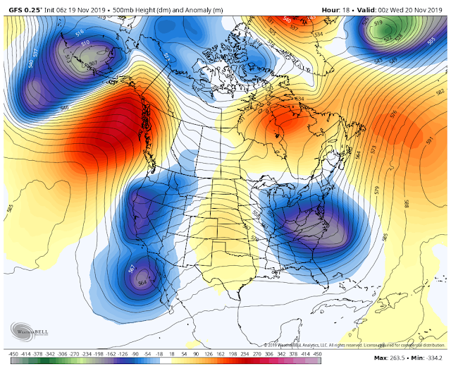
Analysis At 11 PM MST Monday Night.
Valid At 5 PM MST Tuesday.
Valid At 5 PM MST Wednesday.
A cutoff mid-upper level low is located southwest of San Diego, California this morning. This storm will move northeastward, weaken, and get absorbed by a second low moving south down the West Coast Tuesday night. By Wednesday evening a second, stronger and colder cutoff low will be located over southern California. The forecast models then move this storm slowly eastward opening it up and weakening it as it slides across New Mexico Friday. Cutoff lows are famous for misbehaving so I wouldn't be surprised if this one slows down or changes its track across the area.
Storm Total Rainfall Amounts Forecasts.
Valid At 5 PM MST Friday.
European (ECMWF).
Valid At 5 PM MST Friday.
Canadian (GEM).
Valid At 5 PM MST Friday.
NWS.
Valid At 5 AM MST Friday.
Storm Total Snowfall Amounts Forecasts.
GFS.
Valid At 5 PM MST Friday.
European (ECMWF).
Valid At 5 PM MST Friday.
Canadian (GEM).
Valid At 5 PM MST Friday.
NWS.
Valid At 5 AM MST Friday.
Valid At 5 AM MST Thursday.
More Rain - Windy - Colder.
A complex weather pattern will set up over the area tonight into Friday. This will lead to a mix of wintry weather across the area. Scattered rain showers will pop up beginning tonight continuing into Wednesday. A few thunderstorms will also be possible. Our chances for rain tonight into Wednesday across the Pecos Valley increase to 40% then 50% on Wednesday.
Highs today across Southeastern New Mexico will be in the mid to upper 70's with Carlsbad possibly reaching 80º.
A strong Pacific cold front will approach the area from the west on Thursday, passing through Southeastern New Mexico Thursday night. Meanwhile a backdoor cold front will work its way southward down the Eastern Plains Thursday. Highs on Wednesday and Thursday locally will be in the upper 60's to the low 70's ahead of the cold fronts.
Southwesterly winds will gust up to around 40 mph Wednesday afternoon. A High Wind Watch remains in effect for the Guadalupe mountains Wednesday for southwesterly winds becoming sustained at 35 to 45 mph with gusts to 65 mph.
Scattered rain showers and perhaps a few isolated thunderstorms return on Thursday as the cold front and upper level storm to our west approaches. Storm total rainfall amounts in the local area will be in the .25" to .50" range with a few higher totals especially if thunderstorms develop over those areas.
Heavy Mountain Snows Possible.
A Winter Storm Watch remains in effect for parts of the northern mountains of New Mexico for Wednesday afternoon through Thursday evening. Snowfall totals of one to two feet are possible.
Snow levels will remain very high (around 10,000' to 11,000') over the Sacramento mountains until Wednesday night. Snow levels will drop to around 8,000' to 9,000' late Wednesday night and lower during the day on Thursday to around 7,500 by late afternoon. By Thursday night snow levels will fall to around 6,500'.
Depending upon the speed and track of this incoming storm snowfall totals across the Sacramento mountains will vary. For now the Cloudcroft and Sunspot areas look to get around 1" to 4". If the storm slows down and takes a more southerly track these totals would be higher into Friday. Ski Apache may pick up 6" to 12". Rain should change over to snow late Wednesday night. Snow levels will start out high around 9,000' Thursday morning and lower through the day into the evening.
The Truth Is Stranger Than Fiction - And Sometimes It Hurts!


Comments
Post a Comment
Your comments, questions, and feedback on this post/web page are welcome.