Posts

Showing posts from April, 2021

My Blog Archive List (July 2010 - August 2025).

Show more

About

Cannon AFB (KFDX) Radar Outage

Updated 10/01/2025 11am The Cannon Air Force Base (KFDX) WSR-88D will remain inoperable for an extended period due to a hardware failure at the site. Parts have been ordered. There is currently no estimate on when the radar will return to service. KFDX radar is the only radar coverage for portions of eastern New Mexico. However, you may find KPUX, KAMA, KLBB, and KMAF radars useful. If you have questions or concerns, please contact Cannon AFB Public Affairs at 575-784-4131.

Viewing My Web Page

If you are viewing my web page on your cell phone, then be sure and click on the three white bars located in the top left-hand corner of the page (only visible on your phone). This is the menu bar, and it opens up additional links and graphics. Such as forecast maps, severe weather outlooks, current conditions, radar and satellite links, and more.

Rainfall Totals For The Past 72-Hours.

Image
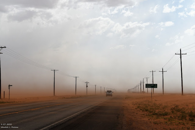
4-27-2021. Blowing San East Of Lamesa, Texas Reported 48-Hour Rainfall Totals. (As Of 5:30 AM MDT Thursday). NWS MesoWest Reported 72-Hour Rainfall Totals. (As Of 5:30 AM MDT Thursday). The Truth Is Stranger Than Fiction!

April Showers & Mountain Snows This Weekend.

Image
RTMA Temperatures. (As Of 4 PM MDT Friday, April 16,2021). RTMA Apaarent Temperatures. (As Of 4 PM MDT Friday, April 16,2021). Surface Map Analysis. ( At Noon MDT  Friday, April 16,2021 ). Surface Map Forecast. (Valid At 6 PM MDT Saturday, April 17, 2021). GFS 500 MB (18,000') Analysis. Looking at the mid-level upper air pattern at noon today (Friday) we find an elongated trough of low pressure draped from southwest of California eastward to well east of the Eastern U.S. seaboard. A weak low was centered over northwestern Kansas. GFS 500 MB (18,000") Forecast. (Valid At 6 PM MDT Sunday, April 18, 2021). A weak mid-level low is forecast to form on the western edge of this mid-level trough of low pressure by Sunday afternoon and evening. This weak storm will help produce mountain snows and lowland rains over New Mexico this weekend. Cold For Mid-April. Low clouds, dense fog, with pockets of light drizzle and mist have blanketed the local area (east of the mountains) for the past...
Blast Furnace Weather Today!

Image
NWS NDFD Peak Wind Gust Forecast Today. NWS NDFD Forecast High Temps Today. NWS Surface Map Forecast.   Hot - Windy - Dusty Day! Monday was hot indeed. Here at our home in northwest Carlsbad, I recorded a high temp of 94ºF. The Carlsbad Airport reached 92ºF, Roswell and Artesia Airports 91ºF, and Hobbs 86ºF. Today's high temps will be similar to yesterday's. A weak Pacific cold front will sweep eastward across New Mexico tonight dropping our temperatures back down into the 80's for the rest of the week. High Wind Warnings are out for the Guadalupe mountains and Wind Advisories are in effect for the Southeastern Plains and parts of southern New Mexico and West Texas.  West winds are forecast to gust up to around 75 mph in the Guadalupe mountains today. West winds are forecast to gust up to around 50 mph across the lower elevations of the area today. Blowing Dust & Critically Dangerous Fire Weather Conditions! Blast furnace weather this afternoon as temps climb up into ...

Blast Furnace Weather Returns.

Image
NWS NDFD Forecast High Temperatures. Today. Tuesday. First 90º Temps Today? Our first taste of summer-like temperatures will occur today and Tuesday as the thermometer rises up into the 90º range. Record high temperatures today are in the low 90's for the local area and the mid to upper 90's for Tuesday.  High Winds - Blowing Dust - Critically Dangerous Fire Weather Conditions Tuesday. Tuesday will be an ugly day weather-wise. High temperatures will be near 90ºF, relative humidity values down into the single digits, and west winds will gusting up to around 50-60 mph. Widespread blowing dust will be possible Tuesday afternoon. Local visibilities will drop down to near zero with little to no advanced warning in our dust-prone areas. West winds are forecast to gust up to around 75 mph in the Guadalupe mountains where a High Wind Watch is in effect for Tuesday. Critically Dangerous Fire Weather Conditions will also prevail. Any grassland, wildland, range, or forest fire will have ...

Americas Spiritual & Political Mindset This Easter Weekend 2021.

Image
My Heart Is Troubled This Easter. Looking at my photo posted above gave me an idea, a thought. The moon was setting behind the Guadalupe mountains when I shot this. I remembered President Reagan's quotes about America being the shining city upon a hill. This brought to mind the following: "You are the light of the world. A city set on a hill cannot be hid. Nor do men light a lamp and put it under a bushel, but on a stand, and it gives light to all in the house. Let your light so shine before men, that they may see your good works and give glory to your Father who is in heaven."—Jesus, from the Sermon on the Mount, Matthew 5:14-16. "For we must consider that we shall be as a city upon a hill, the eyes of all people are upon us; so that if we shall deal falsely with our God in this work we have undertaken, and so cause Him to withdraw His present help from us, we shall shame the faces of many of God's worthy servants, and cause their prayers to be turned into curse...

Current US Hazardous Weather Watch/Warning Map

New Mexico

Eddy County

Guadalupe Mtns Eddy & Culberson County

Chaves County Plains & Mtn's

Lea County

Lincoln County

Otero County

Pagosa Springs, Colorado Flooding Oct 12, 2025

Arizona Flooding - Oct 12, 2025

🔴 Live 24/7 National Weather Radar & Alerts, Weather Intensity Score & YallBot!

Ruidoso Live Webcam

Ski Apache Webcam Live Link

Ski Apache Webcam Live Link
Click On The Image To Open It Up

Cloudcroft Live Webcam

Roswell Live EarthCam

New Mexico Weather Tweets

Average Daily High/Low Temperatures & Rainfall/Snowfall

My Rainfall Totals. 2.1 NNW Downtown Carlsbad, NM.

My Top 10 Most Popular Posts

Artesia, NM Mothership Supercell Thunderstorm. 9-17-2016.

Monster Of A Snowstorm Coming This Christmas Weekend?

Powerful Winter Storm Is Hammering New Mexico! Worst Is Yet To Come.

25th Anniversary Of The Carlsbad, NM (May 31, 1991) Tornado Coming Up.

Major Winter Storm May Paralyze/Bury Parts Of NM & Nearby Areas Tonight Into Wednesday!

2011 Skywarn Spotter Training Classes & My Thoughts.

Tonight's GFS Is As Drunk As This Mornings ECMWF. Historic Snowstorm Next Weekend?

Are We Fixing To Go From Drought To Flood In SE NM?

Major Winter Storm To Hammer New Mexico & West Texas Thanksgiving Week!

Cloudcroft & Ruidoso, NM Seasonal Snowfall Totals.

My Favorite Blog List.

Substack

Disclaimer

This blog and its contents are for informational purposes only! Always have multiple sources of information available to rely upon during severe weather. Do not rely solely on the Internet. Be weather-aware, plan ahead, have a backup plan, and be ready to act before severe weather strikes your location.