My Blog Archive List (July 2010 - August 2025).

Show more

Viewing My Web Page

If you are viewing my web page on your cell phone, then be sure and click on the three white bars located in the top left-hand corner of the page (only visible on your phone). This is the menu bar, and it opens up additional links and graphics. Such as forecast maps, severe weather outlooks, current conditions, radar and satellite links, and more.

Flash Flood Watches Remain In Effect - Another Historic Flash Flood Event Shaping Up?

6-26-2021.
Cumulonimbus Cloud.
Looking East At Brantley Lake Dam.

NWS Midland Doppler Radar.
24-Hour Estimated Rainfall Totals.


GRLevel3_2.0.
Cannon AFB Doppler Radar.
24-Hour Estimated Rainfall Totals.


Thunderstorms moved from northwest to southeast early this morning (around 3:30 AM MDT) and into the Carlsbad area. A Personal Weather Station (PWS) reported 1.91" in the north La Huerta area of town. While on the southern end the Carlsbad Airport only reported a trace of rain. Demonstrating once again how a thunderstorm can be either feast or famine with its associated rainfall. 


Lamesa, Texas had 88 mph thunderstorm wind gusts, a tornado nearby, large hail, downed trees, power lines, and widespread street flooding were reported. Very heavy rainfall from last night's thunderstorms also occurred. The First Baptist Church took in at least 30 people that had lost their homes. The West Texas Mesonet Station reported a 24-hour rainfall total of 5.27" with 3.23" of that falling within 23 minutes.


RAIN 

 • 1 SW FORT SUMNER - 1.79 in.
 • 6 S TEXICO - 1.17 in.
 • 1 NE POJOAQUE PUEBLO - 1.11 in.
 • 6 W PLEASANT HILL - 1.05 in.
 • 4 WSW MILLS - 1.00 in.

 • 5 ESE BLACK LAKE - 0.95 in.
 •  JACONITA - 0.90 in.

 • 1 SE SAN ANTONIO - 0.89 in.
 • 5 N PLEASANT HILL - 0.82 in.
 •  CORDOVA - 0.82 in.

 • 1 WSW MIAMI - 0.78 in.
 • 4 W OCATE - 0.75 in.
 • 2 E LOS ALAMOS - 0.72 in.

 • 1 WSW SPRINGER - 0.69 in.
 • 13 SE TOLAR - 0.67 in.
 • 2 NNE CLOVIS - 0.67 in.
 • 6 NE LAS VEGAS - 0.64 in.

 • 2 NE CHACON - 0.56 in.
 • 3 NW SOLANO - 0.55 in.
 • 1 WSW LOS ALAMOS - 0.54 in.
 • 12 NW PILAR - 0.54 in.
 • 2 WNW CLOVIS - 0.50 in.

 • 1 WNW RED RIVER - 0.49 in.
 • 2 NNE SAN IGNACIO - 0.47 in.
 • 4 N NEWKIRK - 0.47 in.
 • 2 NW EL RITO - 0.47 in.
 • 3 E CLOVIS - 0.46 in.
 • 1 WNW EL RANCHO - 0.45 in.
 • 1 WNW WHITE ROCK - 0.44 in.
 • 1 ESE ABBOTT - 0.43 in.
 • 1 N AGUA FRIA - 0.43 in.
 • 1 W MORA - 0.41 in.
 • 3 NNW TEXICO - 0.40 in.
 • 4 S CLOVIS - 0.40 in.

 • 9 NE RANCHVALE - 0.39 in.
 • 2 WSW RUIDOSO - 0.39 in.
 • 2 SSW ARABELA - 0.35 in.
 • 5 SSW MESA - 0.35 in.
 • 3 SW LLANO - 0.35 in.
 • 2 SSW LOS CORDOVAS - 0.35 in.
 •  ANGEL FIRE - 0.31 in.
 • 2 N EDGEWOOD - 0.31 in.
 • 7 ESE KENNA - 0.30 in.
 • 1 W NAMBE - 0.30 in.

 • 2 ENE LOS ALAMOS - 0.28 in.
 • 2 SW ARROYO SECO - 0.28 in.
 • 1 E WHITE ROCK - 0.27 in.
 • 3 E LOS ALAMOS - 0.26 in.
 • 2 W VALDEZ - 0.26 in.
 • 14 S DURAN - 0.24 in.
 • 16 SSE PUERTO DE LUNA - 0.23 in.
 • 1 E LYDEN - 0.22 in.
 • 1 ESE TRUCHAS - 0.21 in.
 • 3 W EL PRADO - 0.21 in.
 • 1 E ARROYO SECO - 0.21 in.
 • 2 NNE LOS CORDOVAS - 0.20 in.
 • 2 ENE TAOS - 0.20 in.

 • 3 N UTE PARK - 0.19 in.
 • 9 ESE PUERTO DE LUNA - 0.19 in.
 • 1 SSW LA MADERA - 0.18 in.
 • 7 SE YATES - 0.18 in.
 • 1 SSW MORIARTY - 0.18 in.
 • 5 E SHADY BROOK - 0.18 in.
 • 2 ESE SANTA ROSA - 0.18 in.
 • 3 SW PORTALES - 0.18 in.
 • 1 N CANONES - 0.17 in.
 • 1 E RIO RANCHO - 0.17 in.
 • 2 NNE ROWE - 0.16 in.
 • 16 SSE NATL RADIO ASTRONOMY OBS - 0.15 in.
 • 14 W ELKINS - 0.15 in.
 • 4 NW TUCUMCARI - 0.14 in.
 •  ELIDA - 0.14 in.
 • 3 WNW RIO RANCHO - 0.13 in.
 • 15 NNW BITTER LAKE WILDLIFE REF - 0.13 in.
 • 8 S HAYDEN - 0.12 in.
 • 5 E SUMNER LAKE - 0.12 in.
 • 3 NE FARMINGTON - 0.12 in.
 • 2 SSW SANTA CRUZ - 0.11 in.
 • 3 WNW SANTA FE - 0.11 in.
 • 1 SE SAN GERONIMO - 0.11 in.
 • 1 W MOUNTAINAIR - 0.11 in.

 • 5 S TERERRO - 0.10 in.
 • 1 SSW CHAMIZAL - 0.10 in.
 • 10 E CORONA - 0.10 in.
 • 2 N CORRALES - 0.10 in.

 • 7 ESE DES MOINES - 0.10 in.

Last updated:
0919 AM 06/27/20

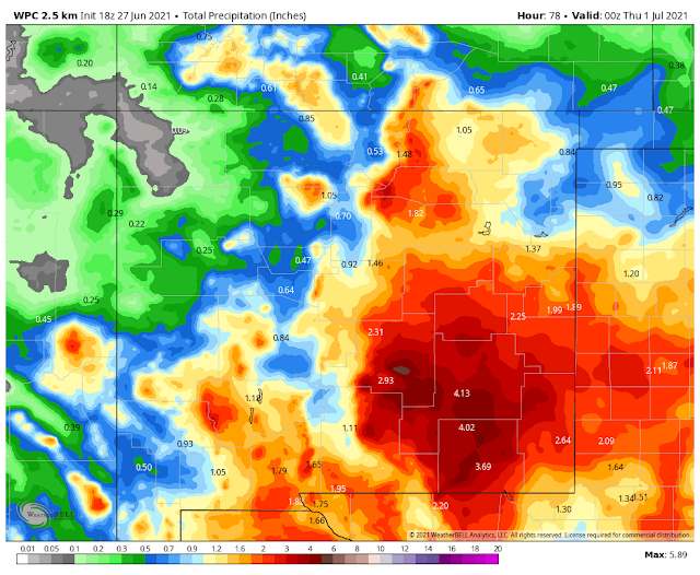
Worrisome News In The Model Forecasts.

(Today Through 6 PM MDT Wednesday).

ECMWF.


GFS.


Canadian GEM.


ICON.


WPC.


NWS.


NAM 3K.


A very worrisome (my opinion) trend continues to show up in all of the forecast models. No matter how you slice or dice their storm total rainfall forecasts...it all points to the same outcome. And that is very heavy to excessive rainfall from today (Sunday) through sunset Wednesday. This on top of what fell yesterday. 

Even the NAM 3K forecast dumps 11" of rain on Roswell for a storm total. That would be a disaster should it actually happen. Looking at the different runs posted above it's clear that they do not agree especially where the heaviest rains will end up falling. They rarely do. It's the trend that is bothering me. Even if you were to cut these totals in half it would still be an impressive event for the local area.

Widespread storm totals of 3" to 6" appear to be the average for the local area between today and Wednesday. Pockets of excessive rainfall could be possible as well. Anywhere from 6" to 18"? Yea I know that 18" near Guadalupe Peak is off the scale. But not if you look at what happened down there in September 2014 (16" fell overnight) it's not that far of a reach to believe.  

See my blog posts below.


During past historic widespread flasih flood events local ranchers and farmers have reported storm totals in the Guadalupe, Sacramento, and Capitan mountains of 20" - 30". They also have reported 24-hour totals of 10" or more. Will this be another history-making event? Time will tell. Parts of Southeastern New Mexico and West Texas got hammered yesterday afternoon into early this morning with 3" to 6" already. 

Flash Flood Watches have been posted for much of the area from today through Monday. Most flash flood deaths occur at night and in vehicles. 

Remember: Turn Around - Don't Drown!

The Truth Is Stranger Than Fiction!

Comments

  1. Tremendous rainfall amounts with flooding yesterday and especially today, June 28th, in El Paso.

    ReplyDelete

Post a Comment

Your comments, questions, and feedback on this post/web page are welcome.

Current US Hazardous Weather Watch/Warning Map

New Mexico

Texas

Arizona

Colorado

Eddy County

Guadalupe Mtns Eddy & Culberson County

Chaves County Plains & Mtn's

Lea County

Lincoln County

Otero County

🔴 Live 24/7 National Weather Radar & Alerts, Weather Intensity Score & YallBot!

Weather With Travis

Tim Vasquez's Forecast Lab

Ruidoso Live Webcam

Ski Apache Webcam Live Link

Ski Apache Webcam Live Link
Click On The Image To Open It Up

Cloudcroft Live Webcam

Roswell Live EarthCam

Average Daily High/Low Temps & Precipitation

Average Daily High/Low Temps & Precipitation

My Precipitation Totals - 2.1 NNW Downtown Carlsbad

My Precipitation Totals - 2.1 NNW Downtown Carlsbad

My Top 10 Most Popular Posts

Artesia, NM Mothership Supercell Thunderstorm. 9-17-2016.

Monster Of A Snowstorm Coming This Christmas Weekend?

Powerful Winter Storm Is Hammering New Mexico! Worst Is Yet To Come.

25th Anniversary Of The Carlsbad, NM (May 31, 1991) Tornado Coming Up.

Major Winter Storm May Paralyze/Bury Parts Of NM & Nearby Areas Tonight Into Wednesday!

2011 Skywarn Spotter Training Classes & My Thoughts.

Tonight's GFS Is As Drunk As This Mornings ECMWF. Historic Snowstorm Next Weekend?

Are We Fixing To Go From Drought To Flood In SE NM?

Cloudcroft & Ruidoso, NM Seasonal Snowfall Totals.

Major Winter Storm To Hammer New Mexico & West Texas Thanksgiving Week!

My Favorite Blog List.

Substack

Disclaimer

This blog and its contents are for informational purposes only! Always have multiple sources of information available to rely upon during severe weather. Do not rely solely on the Internet. Be weather-aware, plan ahead, have a backup plan, and be ready to act before severe weather strikes your location.