Showing posts from January, 2021
NWS Albuquerque Forecasts
NWS Miscellaneous Forecasts
Why Are My Weather Posts Missing From Facebook.
Hello everyone. I just wanted to let you know that my Facebook page was shut down without any warning by Facebook this past Saturday, June 8th. All I was told was that I had violated their community standards. I don't know what triggered that; they didn't tell me. I was told this may be permanent or for six months.
My guess is that it may be because I posted several comments and articles from my Substack page about the riots in LA, and that must have triggered/angered someone, and they complained, thus Facebook shut me down. I don't know this as fact, though. I have appealed this decision, and I'm still waiting for their reply. I have read on X that this has happened to other Facebook users posting about the LA riots as well.
I always share my weather blog posts (that I post here) on my Facebook page and my X page. This included over twelve different New Mexico and West Texas Facebook Community sites. So there are thousands of you out there (based on my views and shares of those posts) who will no longer see those posts. My Facebook page may or may not be restored.
This is another good reason (as the National Weather Service often reminds us) to have multiple ways of receiving severe weather alerts when severe weather threatens your location. My weather web page is one of those ways, and I really appreciate all of you who have and still do use it. Thank you so much!!!
If my Facebook page is restored, I will continue to share my weather blog posts and some of the NWS Watches and Warnings...as I have been doing for years now.
January 30th, 2021. Cloudcroft Ski Resort. Over the past week, the Sierra Blanca Snotel site is down but the last report I saw a couple of days ago indicated that the latest storm had dumped 19.5" of new snow on the mountain. The CoCoRaHS reporting stations in and around Cloudcroft are reporting new snowfall totals of 8.0" to 12.5". The Alto area northeast of Ruidoso is reporting 5.0" to 8.9" of new snowfall. The Ruidoso area 4.6" to 6.5" of new snowfall. The Capitan area 6.5". The Mayhill area is reporting 1.5" to 2.6" of new snowfall. Seasonal Snowfall Totals. (Oct 1st, 2020 - January 31st, 2021). January 2021 Snowfall Totals. Chaves County Snowfall Totals. (January 2021 & Season Totals). Eddy County Snowfall Totals. (January 2021 & Season Totals). Lea County Snowfall Totals. (January 2021 & Season Totals). Lincoln County Snowfall Totals. (January 2021 & Season Totals). Otero County Snowfall Totals. (January 2021 ...
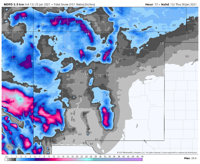
NWS NDFD Total Snowfall Forecast. Today Through 5 AM MST Thursday. NWS Albuquerque Total Snowfall Forecast. NWS NDFD Total Precipitation Forecast. Today Through 5 AM MST Thursday. NWS NDFD Peak Wind Gust Forecast. Today Through 5 PM MST Wednesday. Surface Map Forecasts. NWS NDFD Forecast High-Temperatures. Today. Tuesday. Wednesday. NWS MesoWest Reported Peak Wind Gusts. (24-Hour Gusts Recorded Sunday). Stormy Today Into Tuesday! My Winter Weather Page (Local Road Conditions & More.) A Winter Storm Warning is in effect for the southern Sacramento Mountains from 2 PM MST this Monday afternoon through 11 PM MST Tuesday night. Heavy snow, blowing snow, and near whiteout, conditions are forecast. New snowfall totals of 8"-12" are forecast with locally heavier totals. Travel will become difficult to impossible at times especially at the higher elevations. A Winter Weather Advisory is in effect for the northern Sacramento Mountains from 5 PM MST this Monday afternoon throu...
January 10, 2021. This photo was taken just east of Mayhill. Looking back to the west on U.S. Hwy 82. Light snow overnight left 1/2" to 1" on the ground and by the time we got here most of it had melted. A light glazing of rime ice still coated the pine trees caused by the freezing fog overnight into the early morning hours. Visibile Satellite Image. 8:16 AM MST Sunday, January 24, 2021. Low level southeasterly upslope flow from the Gulf of Mexico worked its way northwestward into Southeastern New Mexico overnight. As this moist and warmer air mass traveled up the slope (caprock) it begin to cool and condense with the result being fog and drizzle across the local area. This will burn off around noontime as the atmosphere begins to mix out with strong down slopping southwesterly winds kicking. A weak dryline will get shoved into the eastern Permian Basin by tonight. Winter Storm Brings A Variety Of Weather To NM. Surface Map Forecasts. 5 PM MST Today. 5 AM MST Monday. 5 PM MST...