

Dangerous/Brutal Arctic Invasion - Wednesday Night Into Thursday Night!

West Of Mayhill, New Mexico.
Blog Updated At 12:49 PM MST Monday, Dec 19, 2022.
Dangerous/Brutal Arctic Invasion.
Wednesday Night Into Thursday.


Canadian (GEM) Mean Sea Level Forecast Map.

For days now all eyes have been on the massive invasion of arctic air slated to spread south and southeast into the Continental US this week. This brutally cold air mass is currently forecast to enter far northeastern New Mexico Wednesday night. Then bulldoze it's way southward into the eastern and southeastern plains late Wednesday night into Thursday morning. Note the Canadian models forecast (above) of a surface high over northwestern Wyoming around sunset with a central pressure of 1055 millibars or 31.15 inches of mercury!
As of this Monday morning there still remains some question as to the timing of the arrival of the arctic front in Southeastern New Mexico. I've chose the Canadian (GEM) forecast model to use because historically it handles these brutally cold air masses fairly well. Best guess at this time (Monday morning) is that the front will arrive early Thursday morning. This will have a huge impact upon our local high temperature forecast Thursday.
If the front arrives sooner than currently is forecast we may not get above freezing. If it arrives later then we will be warmer. It is very possible that our daytime highs over most of the local area will be set between midnight and sunrise Thursday. Our highs in Southeastern New Mexico could range from the 50's to near 60º with a later frontal passage or only in the 20's and 30's with a faster arrival of the front.
Source Region - Northwest Yukon Territories.

RIP, Dawson City, Yukon (-76 / -51C).


Canadian (GEM) Temperature Forecast.

Valid At 11 AM MST Thursday.
Canadian (GEM) Apparent Temperature Forecast.

NWS NDFD Apparent Temperature Forecast.


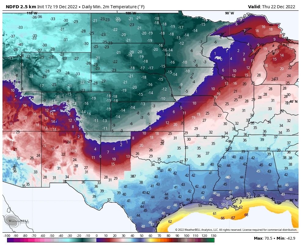
Low Temperatures Thursday Morning.
High Temperatures Thursday.

Low Temperatures Friday Morning.

High Temperatures Friday.


This arctic air mass will be some 30º to nearly 40º below normal over the area by sunset Thursday! Wind chill temperatures and apparent temperatures are forecast to crater rapidly behind the frontal passage Thursday. Life threatening readings will drop as low as -30º to -37º over far northeastern New Mexico Thursday into Friday morning.
Strong and gusty northerly winds will accompany the frontal passage and continue throughout the day with the very tight surface pressure gradient that we be over the region. These northerly winds may be sustained at around 25-35 mph with gusts near 40-50 mph over the area. Strong gap winds in the Guadalupe Pass area will howl in the range also...if not stronger.
Areas of blowing dust will also accompany this frontal passage. I wouldn't be surprised to see a haboob develop with widespread blowing dust reducing the visibility over the area.
Dangerous wind chill and apparent temperature values will be in the -15º to -25º range across the eastern plains Thursday into Friday morning. Across the southeastern plains these readings are currently forecast to drop down into the 0º to -15º range Thursday into Friday morning.
Temperatures are forecast to fall below freezing on Thursday and likely will not rise above freezing until Saturday or possibly Sunday. Low temperatures Friday morning are currently forecast to be in the single digits. Lows are forecast to drop down into the -5º to -15º range across the northeastern and eastern plains Friday morning.
It is very important to remember that these forecasts may and likely will change over the next several days as new model data becomes available and forecasts are adjusted accordingly. But make no mistake this will be a dangerous winter weather event for not only New Mexico but West Texas and much of the nation east of the Rockies. Light snow may fall across parts of northeastern New Mexico but the rest of the state is currently forecast to remain snow free from this winter storm.
What is not clear as of this morning is how far west this brutally and dangerously cold arctic air mass will be able to move in New Mexico. These arctic air masses are notoriously shallow and cold. Typically they are only several thousand feet deep. There have been many times in my lifetime (I'm 64) that I have witnessed temperatures across the Southeastern Plains only remain in the single digits or teens while Ruidoso and Cloudcroft were warmer with readings sometimes in the 40's and 50's. Will this be the case this time? That's not clear this morning.
These actual forecast temperatures, forecast wind chill and apparent temperatures will be life threatening if you are caught outside without the proper clothing and protection. Across Southeastern New Mexico and nearby West Texas this arctic outbreak will impact oilfield operations with the very cold temperatures and wind chill/apparent temperature values. This event will also stress area agriculture related livestock and other animals outdoors. Please take necessary precautions to protect them if possible. More updates as forecasts are updated.
There Are None So Blind As Those Who "Will - Not" To See...107.


Can’t help to notice the cloud cover off the west coast and how a bulk of it could be entrained into the Inter mountain west to provide some moisture for a storm to work on. And with such a huge temperature difference along the boundary that perhaps a low will form coming down into New Mexico due south.
ReplyDelete