

2022 Ends On A Warm & Windy Note.

US Hwy 285 South Of Artesia.
Altocumulus Standing Lenticular Clouds.
Blog Updated At 3:40 PM MST New Years Eve.
A Parade of Pacific Storms Headed Our Way.


Three mid-level short wave troughs of low pressure (circled in red on the GFS 500 Millibar forecast map above) are forecast to impact our regional weather today into mid-week of the first week of the New Year.
Storm #1 will be approaching New Mexico from northern California tonight through Monday. By sunset Monday it is forecast to be centered over northeastern Colorado.
Storm #1 will be approaching New Mexico from northern California tonight through Monday. By sunset Monday it is forecast to be centered over northeastern Colorado.
Storm #2 is forecast to impact our weather Tuesday into Wednesday morning. The third storm is forecast to arrive late next week.
A Pacific cold front will race across the state New Years night through Monday morning.
Today.

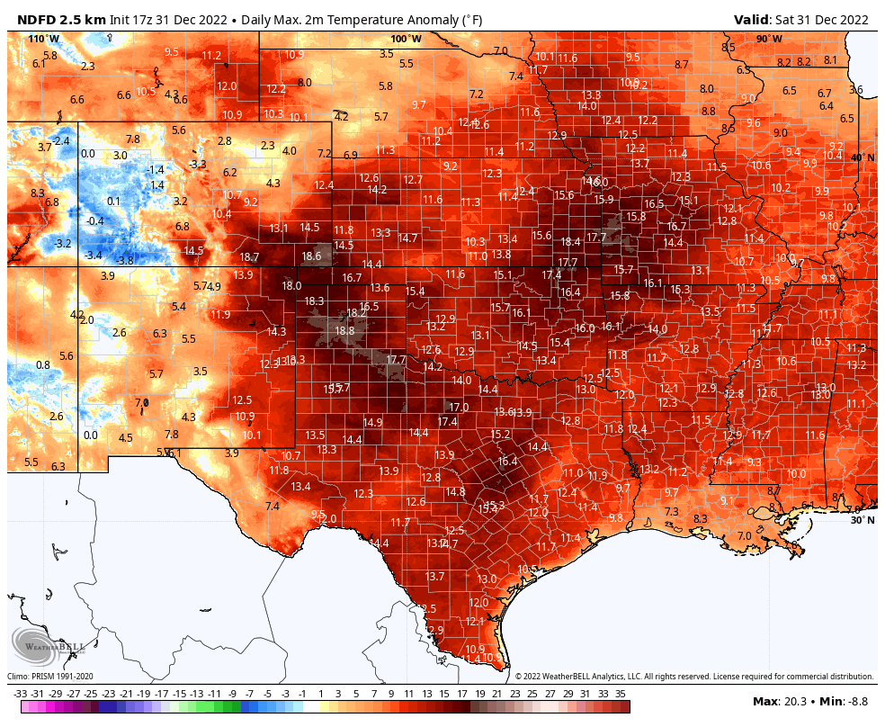
NWS High Temperature Anomaly Forecast Today.
New Years Day.

NWS High Temperature Anomaly Forecast New Years Day.

Monday.

NWS High Temperature Anomaly Forecast Monday.

Tuesday.

NWS High Temperature Anomaly Forecast Tuesday.

2022 Ends On A Warmer Than Normal Note.
Our local high temperatures today and New Years Day are forecast to end up being some 10º to 15º above normal. Highs today and New Years Day across the Southeastern Plains will range from the upper 60's to near 70º.
These balmy temps will come to an end Monday behind the approaching Pacific cold front. Highs are forecast to drop down into the low to mid 50's Monday and Tuesday. These temps will be close to normal for the date.
These balmy temps will come to an end Monday behind the approaching Pacific cold front. Highs are forecast to drop down into the low to mid 50's Monday and Tuesday. These temps will be close to normal for the date.

Scattered lowland rain showers and mountain snows are forecast to accompany our next incoming winter storm. Draw a line from north to south from the northern mountains south through the state to the Texas border. Everyone west of that has a chance of getting rain and or snow. Southeastern New Mexico gets left out again it appears.


Valid Sunday Night Through Monday Evening.
A Winter Weather Advisory has been issued for the southern Sacramento mountains from New Years 11 AM MST New years Day through 8 PM MST Monday evening. Storm total snowfall amounts are forecast to be in the 2" to 5" range above 7,500'. West-southwest winds sustained at around 30-35 mph with gusts near 60 mph will create areas of blowing snow. The moderate to heavy snowfall and the blowing snow may make travel dangerous and difficult.
A Winter Weather Advisory has been issued for the Northern and Southern Sangre de Cristo mountains and the Central mountain chain including the northern Sacramento mountains (the Ruidoso area) from 11 AM MST New Years Day through 8 PM MST Monday.
Storm total snowfall amounts are forecast to be in the 2" to 4" range with 8" above 8,000'. West-southwest winds gusting to around 45 mph will create areas of blowing snow. The moderate to heavy snowfall and the blowing snow may make travel dangerous and difficult.
High Winds Again.

A High Wind Warning remains in effect for the Guadalupe and Delaware mountains today through early this evening. Southwest winds sustained at around 35-55 mph with gusts to around 75 mph are forecast.
A Wind Advisory remains in effect for Eddy and Culberson Counties and parts of West Texas today through early this evening. Southwest winds sustained at around 30-40 mph with gusts near 55 mph are forecast.
Localized areas of blowing will be possible with the higher wind gusts especially over and near the following: Freshly plowed or open farmlands, fields, lots, and highway construction sites.
There Are None So Blind As Those Who "Will - Not" To See...107.


Comments
Post a Comment
Your comments, questions, and feedback on this post/web page are welcome.