

Incoming Winter Storm & The Trend Towards Stormier/Colder/Wetter Weather.

Northeast Of Dunken, NM.
Cirrocumulus Standing Lenticular Cloud.

GFS 500 MB (18,000') Forecast.

Valid At 5 PM MST Monday, December 12, 2022.
GFS 500 MB (18,000') Forecast.

Valid At 5 PM MST Tuesday, December 13, 2022.
Surface Map Forecast.

Today.

Monday.

Tuesday.


NWS NDFD Apparent Temperature Forecasts.


NWS NDFD Storm Total Precipitation Forecast.

Valid Tonight Through Tuesday.
NWS NDFD Storm Total Snowfall Forecast.

Valid Tonight Through Tuesday.


Fast Moving Winter Storm & It's Impacts.
Latest computer model forecast trends have sped up the track of the closed mid-upper level located west of Portland, Oregon this morning. By around sunset Monday the US GFS model run this morning forecasts the low to be centered over central Utah. Then it pivots rather rapidly east and then northeast to south-central Nebraska by sunset Tuesday.
At the surface a strong Pacific cold front will race east out of California and Great Basin into the the Desert Southwest tonight into Monday. By sunset Monday it is forecast to have moved out of New Mexico and into West Texas.
Good news on multiple fronts. First the models have backed off somewhat on our high wind event forecast Monday into Tuesday. Second parts of the states mountains will get fresh snow from this inbound winter storm including the Sac's. Finally the trend towards stormy, colder, and wetter weather is still on track from this week through the Christmas holidays. It definitely will start feeling and looking more like winter over the next couple of weeks.
High Wind Watches are already flying for the Guadalupe mountains for Monday morning through Tuesday afternoon. West winds are forecast to increase to sustained speeds of around 35-55 mph with gusts near 65 mph.
High Wind Watches are already flying for the Guadalupe mountains for Monday morning through Tuesday afternoon. West winds are forecast to increase to sustained speeds of around 35-55 mph with gusts near 65 mph.
High Wind Watches remain in effect for the Sacramento mountains from Monday morning through Monday evening for southwest winds increasing to 30-45 mph with gusts in the 60-65 mph range.
These High Wind Watches will likely be upgraded to High Wind Warnings later today or tonight. Additional Wind Advisories are possible for the valley locations of much of New Mexico especially across southern New Mexico and the eastern one half of the state east of the mountains.
Localized areas of blowing dust will also be possible across the valley locations associated with the stronger wind gusts with the Pacific frontal passage Monday.
Mountain Snowfall & Bitterly Cold Apparent Temperatures.
Light to moderate snow will spread eastward across the state on Monday as the Pacific cold front races eastward. The most favored areas for moderate to locally heavy snowfall will be the southwestern and northern mountains of the state. Parts of the higher elevations of the Gila and northern mountains may see upwards of 4"-8" of new snowfall from this storm.
The higher elevations of the Sacramento mountains may pick up 1" to 2" of the white stuff.
Brief locally heavy snowfall combined with the strong wind gusts may produce near blizzard conditions over the western and northern mountains Monday into Monday night as the Pacific cold frontal passage occurs. Rain showers at the lower elevations of western, northern, and central New Mexico will also change over to snow but at this time only light accumulations are expected.
Apparent temperature values across the higher elevations of western and northern New Mexico will drop down into the 0º to -15º range Tuesday morning. Wednesday morning will feel even colder with these readings becoming more widespread and a few degrees colder. The apparent temperature is like the wind chill temperature except that is also includes the humidity values of the atmosphere. These temperatures will feel colder the "wetter" the atmosphere is.
(Thursday Through Christmas Eve).
6-10 Day Temperature Outlook.

8-14 Day Temperature Outlook.

6-10 Day Precipitation Outlook.

8-14 Day Precipitation Outlook.

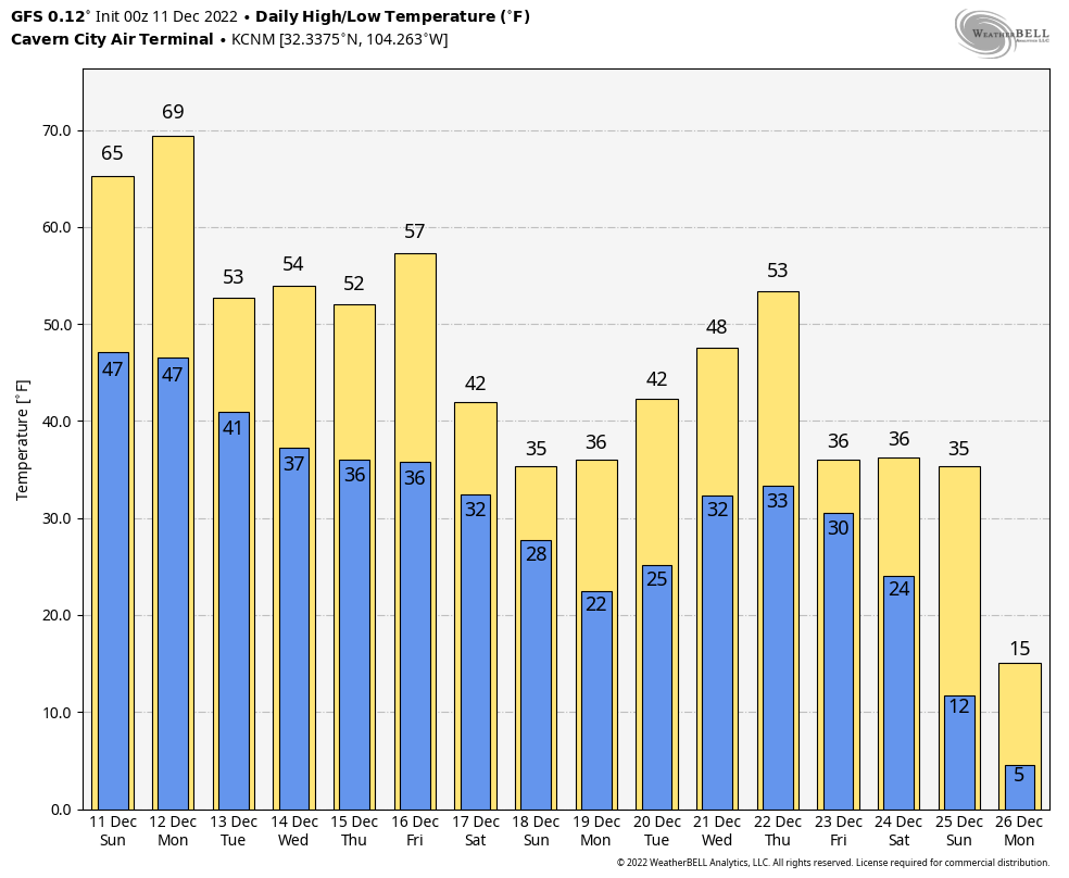
Long range weather forecasting is not my cup of tea. It's hard enough for the computer forecast models to get a forecast right consistently a week in advance much less for a couple of weeks or months. However when looking at the temperature forecast chart above for Carlsbad, NM don't pay too much attention to the forecast values. The takeaway here is the trend.
There Are None So Blind As Those Who "Will - Not" To See...107.


Comments
Post a Comment
Your comments, questions, and feedback on this post/web page are welcome.