

Here Comes The Arctic Plunge!

Valid At 8 AM MST Thursday, Dec 22, 2022.


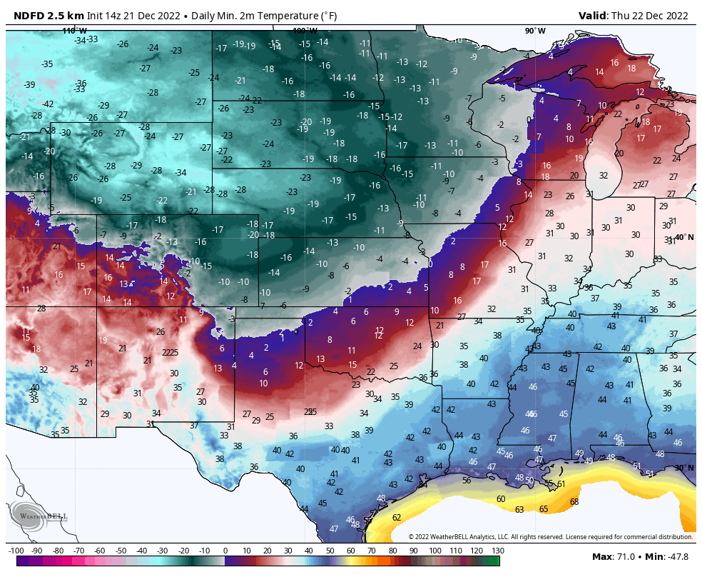
Valid At 5 AM MST Wednesday Morning.

RTMA Apparent Temperatures.


Brutal Cold Behind Strong Arctic Cold Front.
At sunrise this Wednesday morning the arctic cold front was draped across the far Pacific Northwest and northern Rockies. Temperatures across northern Montana are ranging from -10ºF to -37ºF with wind chill temperatures ranging from -30ºF to -64ºF. Note that our neighbors to our north in northeastern and eastern Colorado are under a Wind Chill Warning for readings as low as -40ºF to -55ºF this Wednesday evening through Friday!
And that air mass is headed rapidly southward and southeastward today into Thursday. The front is forecast to enter northeastern New Mexico around midnight tonight and the eastern plains before sunrise Thursday morning.
Once again there are questions as exactly how fast this brutally cold arctic air mass will be able to plow southward into the Southeastern Plains of New Mexico and nearby West Texas. Current forecast trends are slowing the invasion of the arctic front down a little bit. Best guess is that it will reach northern Lea and Chaves Counties after sunrise Thursday and continue south and west into the Pecos Valley by around noontime or early afternoon.
Once again there are questions as exactly how fast this brutally cold arctic air mass will be able to plow southward into the Southeastern Plains of New Mexico and nearby West Texas. Current forecast trends are slowing the invasion of the arctic front down a little bit. Best guess is that it will reach northern Lea and Chaves Counties after sunrise Thursday and continue south and west into the Pecos Valley by around noontime or early afternoon.
When the front does arrive it will be accompanied by falling temperatures, strong gusty north to northeasterly winds in the 25-35 mph range. Locally higher gusts are possible. Areas of blowing dust will be possible especially over and near freshly plowed or exposed farmlands, fields, lots, and highway construction sites.
Local Record Low-High Temperatures.
Local Record Low Temperatures.
(For December 22, 23).

Courtesy Of These NWS Climate Web Pages.
It is possible that some of our daily record low-high temperatures may be threatened over the eastern and southeastern sections of New Mexico on Friday. Records may be tied or broken across northeastern and eastern New Mexico on Thursday and Friday.
Today's High Temps.

Thursday Morning Lows.
Thursday High Temps.

Friday Morning Lows.

Friday High Temps.

Christmas Eve Morning Low Temps.

Christmas Eve High Temps.

Christmas Morning Low Temps.

Christmas Day High Temps.

Life Threatening Wind Chill Temperatures.
The main story with this incoming arctic cold front and its associated very cold air mass will be not only the cold temperatures but also the wind chill temperatures Thursday into Friday across the state and area.
High temperatures in northeastern New Mexico including the Clayton area are only forecast to rise a couple of degrees above zero on Thursday. With northeasterly winds gusting up into the 35-40 mph range tonight into Thursday their wind chill temps will drop down as low as -30ºF if not colder. Wind Chill Warnings are in effect for northeastern New Mexico from 11 PM MST tonight through 11 AM MST Friday for wind chill temps as low as -30ºF.
Clovis is looking at a high temp on Thursday of only around 18ºF. Northeasterly winds gusting up to around 35 mph on Thursday will send their wind chill temps down as low as -20ºF. Wind Chill Advisories are in effect for their area from 5 AM MST Thursday through 11 AM MST Friday for Wind Chill temps as low as -20ºF.
Clovis is looking at a high temp on Thursday of only around 18ºF. Northeasterly winds gusting up to around 35 mph on Thursday will send their wind chill temps down as low as -20ºF. Wind Chill Advisories are in effect for their area from 5 AM MST Thursday through 11 AM MST Friday for Wind Chill temps as low as -20ºF.


Our high temps today in the Southeastern Plains are forecast to rise up into the mid-upper 50's after the freezing fog and low clouds burn off later this morning.
High temperatures on Thursday will be tricky and highly dependent upon the arrival of the arctic cold front. Current thinking is that our highs across the Pecos Valley will be near 50ºF and that will be early in the morning. If the front arrives sooner than forecast we may not get this warm.
Ruidoso is forecast to see high temps near 50ºF today and Thursday. Only the mid 30's for Friday. Cloudcroft is expecting to see their highs near 40 today and Thursday. There is a fly in the ointment with these forecast high temps. This arctic air mass is very shallow (only a couple of thousand feet deep) thus the coldest air associated with it may not be able to reach high enough to drop Cloudcroft's temps into the freezer like the plains. The eastern slops of the Capitan, Sacramento, and Guadalupe mountains will see the coldest temps Thursday night into Friday.
Ruidoso is forecast to see high temps near 50ºF today and Thursday. Only the mid 30's for Friday. Cloudcroft is expecting to see their highs near 40 today and Thursday. There is a fly in the ointment with these forecast high temps. This arctic air mass is very shallow (only a couple of thousand feet deep) thus the coldest air associated with it may not be able to reach high enough to drop Cloudcroft's temps into the freezer like the plains. The eastern slops of the Capitan, Sacramento, and Guadalupe mountains will see the coldest temps Thursday night into Friday.
A Wind Chill Watch is effect for Eddy, Lea, and Culberson Counties and over parts of West Texas from Thursday afternoon through Friday morning for Wind Chill temps dropping as low as -15ºF. Northeasterly winds will gust up into the 25-35 mph range tonight into Friday morning.
Our low temperatures Friday morning are currently forecast to be in the single digits with afternoon highs only in the teens and twenties. We will drop down below freezing Thursday afternoon and will not get above freezing until Christmas Eve...maybe. I'm not convinced that the forecast models are cold enough with their temps associated with this outbreak. Historically they often are too warm and this may be the case with this one. So do be surprised if we end up being colder than currently forecast for Thursday, Friday, and Saturday.
For those of you who livestock and pets that live outdoors please take the necessary precautions to protect them as much as possible. Make sure they have adequate food and water as well as shelter for the brutal cold and wind chill temps.
Oilfield operations across Southeastern New Mexico and West Texas will be impacted by this brutally cold arctic air mass but not to the level of the February 2021 outbreak or the February 2011 outbreak. Having spent 21 years of my life as a Gas Plant Operator I can tell you that this won't be fun for my former co-workers and friends still out in the patch.
There Are None So Blind As Those Who "Will - Not" To See...107.


Comments
Post a Comment
Your comments, questions, and feedback on this post/web page are welcome.