Warm & Windy Friday - Chance For Rain Saturday & Sunday.
Near Sitting Bull Falls.
Valid At 11 AM MST Friday, Dec 2nd, 2022.
Welcome to the beginning of the meteorological winter. An interesting upper air pattern will directly affect our local weather Friday into Sunday. A strong branch of the Subtropical Jet Stream will bisect the state from southwest to northeast on Friday. Strong winds aloft associated with this jet stream will mix down to the surface early Friday morning. As the jet stream wind speed maximum pulls away from the state a cold front will push southward through the state Friday night into early Saturday morning.
Today.
Friday.
Saturday.
Sunday.
Local thermometers will take a ride on the roller coaster today into the weekend. Continued cool but warming up today. A big warmup is expected on Friday with highs in Southeastern New Mexico rising up into the low to mid-70's. There may even be a few upper 70's. A cold front Saturday knocks those highs back down to near 50º to the low 50's. Then a warmup commences again on Sunday with our highs in the low to mid 60's.
Those of you who live in the Ruidoso and Mayhill areas will see highs today and Friday in the upper 50's to the low 60's. Sunday will be in the low to mid 50's.
Those of you who live in the Cloudcroft area will see highs today, Friday, and Saturday in the mid 40's. Sunday should be in the upper 40's. The Sacramento/Weed, Timberon, High Rolls and Mountain Park areas will see highs today, Friday, and Saturday in the low to mid 50's. Highs on Sunday will be in the mid 50's.
Those of you who live in the Cloudcroft area will see highs today, Friday, and Saturday in the mid 40's. Sunday should be in the upper 40's. The Sacramento/Weed, Timberon, High Rolls and Mountain Park areas will see highs today, Friday, and Saturday in the low to mid 50's. Highs on Sunday will be in the mid 50's.
Valid Friday.
Strong southwesterly winds sustained at around 30-50 mph are forecast to gust up to around 75 mph in the Guadalupe mountains on Friday. A High Wind Warning is in effect from 1 AM - 6 PM MST Friday.
A High Wind Watch is in effect for the northern Sacramento mountains from late tonight through Friday afternoon for west winds sustained at around 25-40 mph with gusts near 60 mph.
A High Wind Watch is in effect for the southern Sacramento mountains late tonight through Friday afternoon for west winds sustained at around 30-35 mph with gusts near 60 mph.
Valid Saturday Through Sunday Morning At 5 AM MST.
A disturbance imbedded within the Subtropical Jet Stream will help produce scattered light to moderate rain showers over the area Saturday into Sunday. Our chances for measurable rainfall across the Southeastern plains stands at 20% - 40%. The Sacramento mountains have a 60% chance of seeing measurable rainfall Saturday and Saturday night and this drops off to a 30% chance on Sunday.
Rainfall totals by Sunday morning are generally forecast to be around one tenth to one quarter of an inch across the Southeastern Plains, and one quarter to three quarters of an inch over the Sacramento mountains. Some locals may get a little more than this and some less.
Unfortunately for the Cloudcroft and Ski Apache areas this won't be good news for them. The snow level will be high with storm since it has a subtropical moisture tap associated with it. Snow levels generally will be near 10,000'.
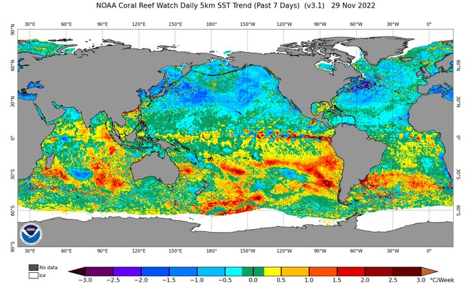
La Niña May Weaken This Winter!
Some good news w/ regard to the triple-dip La Niña. The EPAC has begun warming. What does it mean? Wx pattern shifts for much of Western U.S. will be more common this winter from influences like the MJO. Higher precipitation chances in central NM in DJF. Spring not as dry.
Weather On This Date - December 1st:
Roswell recorded 9.9" of snow in 1931.
Artesia recorded 14.0" of snow in 1931 and a low of 5º in 1976. On November 30th 1976 Artesia recorded its coldest low in November history with -10º.
Carlsbad recorded 7.0" of snow in 1931 and in 2009. Carlsbad had 12" on snow on the ground on this date. Carlsbad's 3-day snowfall total (Nov 30 - Dec 2) was 25.1".
Hope recorded 18.0" of snow and their 3-day snowfall total (Nov 30 - Dec 2) was 25.0".
Elk recorded 13.0" of snow in 2009 with 19" on the ground. Data is missing for the 1931 storm but the nearby Flying H Ranch recorded 14.0" of snow with a 3-day storm total of 20.0".
Mayhill recorded 12.0" of snow in 1931 with 22" on the ground and a 3-day storm total of 33.0" They had 30" on the ground on Dec 2, 1931.
Cloudcroft recorded 13.0" of snow in 1931 with 24" on the ground with a 3-day storm total of 31".
Capitan recorded 6.0" of snow in 1931 with a 3-day storm total of 12.5".
There Are None So Blind As Those Who "Will - Not" To See...107.


Comments
Post a Comment
Your comments, questions, and feedback on this post/web page are welcome.