Goodbye Mild Fall-Like Weather - Hello Winter!
Carlsbad, NM Public Library.
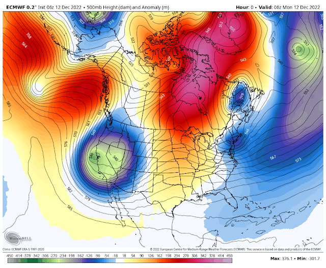
As has been the case for the past several mornings dense fog and low clouds with visibilities less than a quarter of a mile cover just about all of the eastern and Southeastern Plains of New Mexico and much of West Texas early this morning. This will quickly burn off this morning as strong southwesterly downsloping winds kick in ahead of our approaching winter storm.
Today.
Tuesday.
Wednesday.
Tuesday Morning.
Wednesday Morning.
NWS NDFD Storm Total Snowfall Forecast.
Fast Moving Winter Storm & It's Impacts.
At the surface a strong Pacific cold front will move into western and northwestern New Mexico before noon today then race east across the rest of the state by sunset.
Out ahead of the cold front the dryline will interact with the approach cold front this evening across parts of the northeastern Permian Basin helping to produce a few scattered thunderstorms. Some of these will be capable of producing hail, strong wind gusts, and locally heavy rainfall.
High Wind Warnings will be in effect for the Guadalupe mountains from 10 AM MST this morning through 3 AM MST Wednesday morning. Southwest winds are forecast to increase to sustained speeds of around 35-45 mph with gusts near 65 mph.
High Wind Warnings are now in effect for the Sacramento mountains from this morning through late this evening for southwest winds increasing to 25-40 mph with gusts in the 60-65 mph range.
Localized areas of blowing dust will also be possible across the valley locations of the state associated with the stronger wind gusts with the Pacific frontal passage today.
Mountain Snowfall & Bitterly Cold Apparent Temperatures.
Snow will spread eastward across the state on today as the Pacific cold front races eastward. The most favored areas for moderate to locally heavy snowfall will be the southwestern, western and northern mountains of the state. These areas are expecting to see up to 3"- 4" of new snow with locally 4"- 6" at the higher peaks. The highest peaks may see up to a foot of new snow. Areas of blowing snow and snow squalls associated with the frontal passage will cause hazardous and difficult driving conditions. Winter Weather Advisories are out for these areas today.
Snow will spread eastward and into the Sacramento mountains today. Updated forecasts now call for 3"- 6" of new snow above 7,500' with locally higher totals possible. Areas of blowing snow will make driving hazardous and difficult at times. The Ruidoso area may see up to 3" - 5" of new snow. Ski Apache may get 5" - 11".
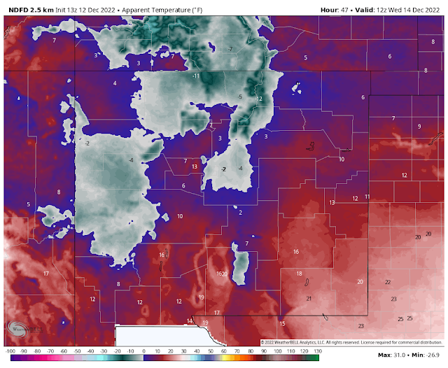
Apparent temperature values across the higher elevations of western and northern New Mexico will drop down into the 0º to -15º range Tuesday morning. Wednesday morning will feel even colder with these readings becoming more widespread and a few degrees colder.
Apparent temperatures across the Sacramento mountains will drop down into the 0º to -5º range late tonight into Tuesday morning. Westerly winds will still be strong and gusty Wednesday which will drop the apparent temperatures down into the 0º to -7º range Wednesday morning.
The apparent temperature is like the wind chill temperature except that is also includes the humidity values of the atmosphere. These temperatures will feel colder the "wetter" the atmosphere is.
Mild afternoon high temps are forecast for the Southeastern Plains today with readings in the mid 60's to near 70. Southwesterly winds sustained at around 20-30 mph with gusts near 40 mph are expected. Localized blowing dust will also be possible especially with the frontal passage late this afternoon and early this evening.
Colder air will overspread the state and region behind the Pacific cold frontal passage. An arctic cold front is forecast to arrive around Friday reinforcing the cold air. Again long range trends and forecasts keep us below normal temperature wise for the most part later this week through the Christmas holidays.
Trouble In Model Land.
Mayhem reigns within the computer model forecast world and here is why. The forecaster on duty yesterday afternoon at the Albuquerque National Weather Service Office wrote an excellent Area Forecast Discussion (AFD) summarizing what is transpiring.
Quote;
"The complex weather pattern of late across the Western U.S. is due to a rapid warming of the equatorial eastern Pacific Ocean as Kelvin waves take over and La Nina weakens.
The warming has resulted in just enough deep thunderstorm activity southeast of HI, which helps draw at least a portion of the polar jet farther south over the EPAC. In other words, supergeostrophic flow just north of HI has to get back into geostrophic balance because there is now a strong temperature difference between the poles and equator in the EPAC.
The high amplitude ridge over the Aleutian Islands is forced westward allowing closed lows to drop south over the PACNW and CA. At any rate, the high amplitude ridge over the Gulf of AK is expected to allow the closed low that moved over NM Monday to develop into a large vortex over central Canada late week into next weekend.
Operational GFS keeps a relatively weak closed low off the central CA coast that eventually swings inland over Northern Baja on day 8. Operational ECWMF dampens this wave out with little to no sensible weather impact for NM next weekend as this open wave moves through.
As the EPAC continues to warm, expect a good deal of run to run changeability from global model runs as they attempt to properly model tropical convection."
There Are None So Blind As Those Who "Will - Not" To See...107.


Comments
Post a Comment
Your comments, questions, and feedback on this post/web page are welcome.