High Winds/Blowing Dust/Critically Dangerous Fire Weather Conditions- Spring Has Sprung!
Capitan Mountains.
Looking Southwest From St Hwy 246.
Blog Updated At 1:16 PM MST Sunday, February 25, 2024.
Valid At 5 AM MST Tuesday Morning.
GFS 500 MB (18,000' MSL) Analysis.
GFS 500 MB (18,000' MSL) Analysis.
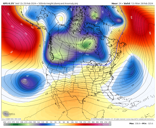
GFS 500 MB (18,000' MSL) Forecast.
Valid At 5 AM MST Monday Morning.
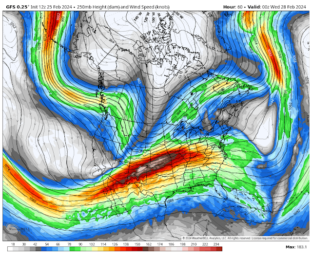
GFS 250 MB (34,000' MSL) Jet Stream Forecast.
Today.
Monday.
High Winds/Blowing Dust/Critically Dangerous Fire Weather Conditions!
A developing potent winter storm was located over the far southeastern Gulf of Alaska this Sunday morning. A closed mid-upper level low was located well west of Los Angeles. A mid-upper level longwave trough of low pressure will strengthen and swing southeast out of the Pacific Northwest and across the Rockies Monday into Wednesday. The southern portion of this trough will sweep across New Mexico on Tuesday as the closed low to our west gets absorbed into the trough.
At the surface a Pacific cold front will swing southeastward across New Mexico and the area Tuesday into Wednesday.
Strong mid-upper winds aloft will mix down to the surface across the area Monday and Tuesday. Aided by the tightening surface pressure gradient and much above normal temps. Winds at the 10,000' level (700 MB) are forecast to be in the 50 to 75 knot/58 to 86 mph range. Winds at the 500 MB level (18,000' MSL) are forecast to be around 95 knots/110 mph while at the jet stream level (250 MB's or 34,000' MSL) a 180 kinot/207 mph will be located over northern New Mexico Tuesday afternoon.
Parts of New Mexico and parts of West Texas are already under High Wind Watches for Monday afternoon into Tuesday night.
A High Wind Warning is in effect for the Guadalupe Mountains of Eddy County and Culberson County in West Texas from 1 PM MST Monday afternoon through 5 AM MST Wednesday morning. West winds sustained at 40 to 60 mph with gusts near 80 mph are currently forecast. These gusts could be higher.
A High Wind Watch is in effect for parts of southern and western New Mexico and Otero County including the southern Sacramento Mountains Monday evening through Tuesday evening. Currently west winds are forecast to become sustained at 30 to 40 mph with gusts near 65 mph. Higher gusts are possible.
A High Wind Watch is in effect for Chaves and Lincoln Counties as well as northeastern and eastern New Mexico Monday evening through Tuesday evening. West winds will become sustained at 35 to 45 mph with gusts near 65 to 70 mph. Higher gusts are possible.
A High Wind Watch is now in effect for Eddy, Lea, Culberson, and parts of West Texas Tuesday morning through Tuesday evening. West winds are forecast to become sustained at 40 to 50 mph with gusts near 70 mph. Higher gusts are possible.
A Winter Storm Watch is in effect for the Tusas Mountains of northern New Mexico including the Chama area late tonight through Tuesday evening. New snowfall totals of 6" to 12" are forecast with peaks above 10,000' getting as much as 20".
Red Flag Warnings and Fire Weather Watches are also in effect for many areas today through Monday due to very dry conditions, single digit relative humidity values, and strong winds.
Additional watches, warnings and advisories will likely be issued by our local National Weather Service Offices (NWS) today and Monday.
Areas of blowing dust are forecast to develop Monday afternoon into Tuesday evening. How extensive this will be depends upon how much the mid-high level cloud cover factors in. In other words, if our skies remain more on the cloudy side Monday and Tuesday, then the high winds and areas of blowing dust may be limited somewhat. If not, then the stronger wind gusts will prevail and the blowing dust will be more widespread.
A widespread high wind and blowing dust event looks very possible on Tuesday. Any wildland or forest fires that develop will have the ability to rapidly spread and grow in the very dry conditions and high winds.
Travel on north/south oriented roads and highways will be dangerous due to the crosswinds during the strongest winds and gusts.
Current model forecasts indicate that westerly winds across Eddy County may become sustained Monday evening through Tuesday evening in the 30 to 50 mph range with gusts in the 65 to 75 mph range. Higher gusts are possible.
Localized power issues/outages may be a problem in some areas especially if power and utility lines are blown down. Tree limbs and trees could also be blown down. Damage to roofs, homes, west facing windows, fences, as well as sheds, barns, and other outbuildings may occur. Irrigation sprinkler systems may also be damaged or destroyed. Especially in those areas that see wind gusts of 65 mph and higher.
Sudden drops in the visibility down to zero will occur during the strongest wind gusts. Especially in our dust prone areas such as freshly plowed, cultivated or exposed farmlands, fields, lots, and highway construction sites. Blinding dust storms creating brownout conditions especially on Tuesday may cause some roads and highways to be closed.
The higher elevations of the Sacramento Mountains (generally 8,000' and higher) has a slight chance for snow shoers Tuesday into Tuesday night. Current forecast models indicate an inch or less of snowfall. Ski Apache could see a little more than this. Another chance for light snow again Wednesday and Wednesday night.
Please check my weather web page often for the latest updates on forecasts, watches, warnings, advisories, and current conditions.
There Are None So Blind As Those Who "Will - Not" To See...107.


Comments
Post a Comment
Your comments, questions, and feedback on this post/web page are welcome.