Spring-Like Weather Wednesday - High Winds/Blowing Dust/ Very High Fire Danger!
South Of Cloudcroft, New Mexico.
(Valid At 5 PM MST Wednesday).
(Wednesday).
(Wednesday - Thursday).
Today.
Spring-Like Weather Wednesday - High Winds/Blowing Dust/ Very High Fire Danger!
Soon (Thursday, Feb, 29th) our 2023-2024 winter season will end. Welcome to spring. But don't think for a minute that we won't have any more winter weather. Far from it. In fact in some years our late winter, and early spring time frame produces some of our worst winter storms.
For example in March of 1958 the Cloudcroft National Weather Service Climate Co-Op Station recroded a whopping 82.0" of snowfall for the month. Compare this with their long term average seasonal snowfall average (October 1st - March 31st) of 74". The 1957 - 1958 winter season saw 178.0" of snowfall in Cloudcroft. So far this year they've had 50.9". The Ski Apache CoCoRaHS Station is reporting a seasonal total of 87.8" so far.
The Ruidoso NWS Climate Co-Op Station 24.3" of snowfall during April of 1983.
In April of 1983 the El Paso National Weather Service Office then located at the International Airport, on the northeast side of the city, recorded an incredible 16.5" for the month.
The Artesia NWS Climate Co-Op Station recorded 15.5" of snowfall that month. Most of this snowfall for all of these locations (Roswell, Artesia, Carlsbad, and Hope) in April 1983 fell from one storm. The Hope NWS Climate Co-Op Station measured 22.5".
The Carlsbad Airport recorded 11.7" of snowfall that month. And the Roswell Airport 5.3". The Hobbs NWS Climate Co-Op Station recorded 9.0" of snowfall in April 1983. The Tatum NWS Climate Co-Op Station recorded 12.5".
During March 1973 the Albuquerque NWS Office located at the Airport recorded 13.9" of snowfall.
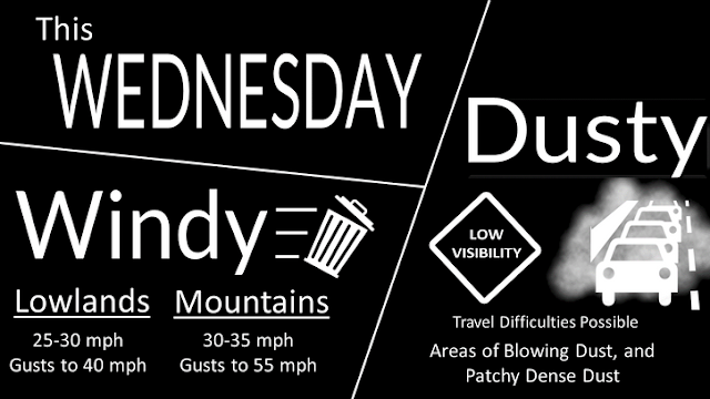
Back to reality. A passing upper level disturbance will sweep across northern New Mexico on Wednesday. This will help tighten up the surface pressure gradient as a Pacific cold front moves from northwest to southeast across the area. Strong winds aloft will also mix down to the surface to make for a windy and dusty day.
A High Wind Watch remains in effect for the Guadalupe Mountains of Eddy County and Culberson County in far West Texas from Wednesday morning through Wednesday evening. West winds are forecast to become sustained at 35 - 55 mph with gusts to 70 - 80 mph.
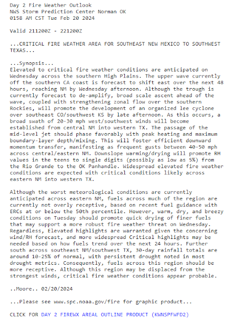
Red Flag Warnings and Fire Weather Watches have been posted for much of the area for Wednesday. As much as possible please refrain from any outdoor activities that involve the use of sparks or flames. Any wildfire or forest fire that potentially could develop will have the ability to rapidly spread and grow.
Critically Dangerous Fire Weather Conditions will develop over much of the state as strong and gusty winds combine with single digit humidity values, very dry conditions, and ample fuels to make produce dangerous fire weather conditions.
Areas of blowing dust will develop across much of the area Wednesday during the strongest winds...late morning into early evening hours. Localized areas of blowing will reduce the visibility down to near zero with little to no warning. This will be especially true in our more dust prone locations such as: Freshly plowed or cultivated farmlands, open or exposed fields, ots, and highway construction sites.
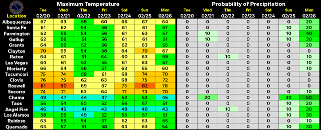
My thermometer on my Davis Wireless Vantage Pro 2 Plus Personal Weather Station just hit 80.0F at 12:15 PM MST. The last time I saw 80F here at our home in Carlsbad was Nov 8th, 2023 with a high temp of 86F.
I expect to see additional watches, warnings, and advisories issued by our local National Weather Service Offices in Midland, Lubbock, Albuquerque, and El Paso later today into tomorrow as conditions warrant and change.
As always check my weather web page for all of the latest updates at...
There Are None So Blind As Those Who "Will - Not" To See...107.


Comments
Post a Comment
Your comments, questions, and feedback on this post/web page are welcome.