Wild Day With High Winds - Blowing Dust- High Fire Dangers - Near Blizzard Conditions Northern NM Mtns.
US Hwy 70 12 Miles West Of Roswell, NM.
Today At 5 PM MST.
NWS NDFD Precipitation Forecast.
NWS NDFD Total Snowfall Forecast.
Valid Today Through 5 PM MST Thursday.
European (ECMWF) Total Snowfall Forecast.
Significant Widespread High Wind/Blowing Dust Event Today!
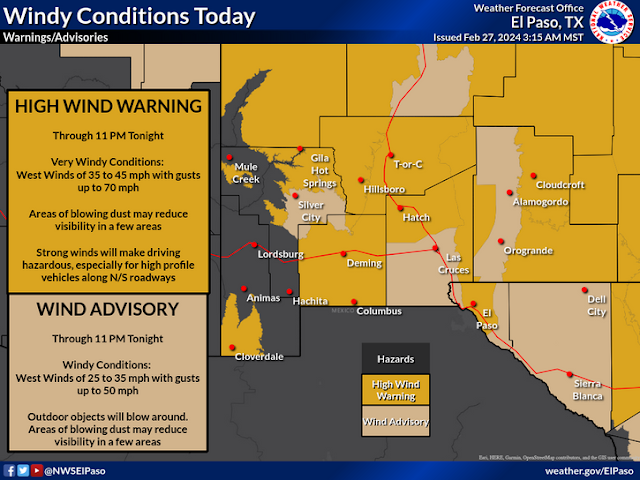
As of 7 AM MST this Tuesday morning just about every single county in New Mexico is under a High Wind Warning or a Wind Advisory. To say that today will be windy statewide is somewhat of an understatement.
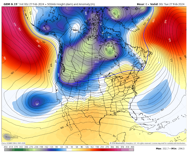
The polar jet and the subtropical jet streams will converge of the state today. Very strong winds aloft will mix downward with the daytime heating today. These winds may be tempered somewhat in some areas depending upon the amount of cloud cover. Nevertheless it is going to be very windy statewide.
At the surface strong leeside trough along with a tightening surface pressure gradient will occur as a cold front slides south and southeast through the area this afternoon and evening.
Westerly winds are forecast to gust up into the 60 to 75 mph range within the High Wind Warning areas. Westerly winds are forecast to gust up into the 50-60 mph range within the Wind Advisory areas.
This mornings NWS NDFD peak wind gust swatch forecast indicates peak gusts in the Guadalupe Pass area may be close to 100 mph today. A High Wind Warning remains in effect for the Guadalupe Mountains of Eddy County, and the Guadalupe and Davis Mountains of West Texas. West winds are forecast to become sustained at 40 to 60 mph with gusts near 85 mph. Higher gusts are possible.
High Wind Warnings remain in effect for today for Eddy, Lea, Culberson, Chaves, Lincoln, and Otero Counties. West winds are forecast to become sustained generally in the 35 to 45 mph range with gusts in the 65 to 75 mph range. Higher gusts are possible.
A Winter Storm Warning remains in effect through 8 PM MST this evening for the northern Sangre de Cristo and Tuscas Mountains. Heavy snow along with blowing and drifting snow will cause white conditions and near-blizzard conditions at times. Snowfall totals of 6" to 10" are forecast with 12" or more above 10,000'. Winds gusting up to 65 mph may cause some damage and aide in the production of blowing and drifting snow. Travel is discouraged in these areas. Travel may become impossible and life threatening n some areas.
Snowfall Wednesday into Thursday across the Sacramento Mountains currently is forecast to be a couple of inches or less generally above 7,000'. This may change.
Widespread Blowing Dust & Wind Damage!
A remote automated weather station located on Salinas Peak, northwest of Tularosa at 8,933' has already clocked a peak wind gust this morning of 86 mph. San Augustin Pass (5,902') located east of Las Cruces on US Hwy 70 has recorded a peak wind gust of 74 mph. A Dust Storm Advisory was issued for parts of Otero County yesterday afternoon and evening for blowing dust and blowing sand (from White Sands Natl Park). A repeat of that is possible today.
Widespread blowing dust is expected to develop most of southern and southeastern New Mexico later today. Along with parts of West Texas. That is if,and that's a big if, the extensive mid and high level clouds don't prevent the stronger winds aloft from mixing down to the surface.
Visibilities will be reduced in many areas below 1-3 miles. In our more dust prone locations sudden drops in the visibility down to zero with no warning will occur in the stronger wind gusts. This includes: Freshly plowed or cultivated farmlands, open and exposed fields and lots, and highway construction sites.
Remember that we have had a long history of multi-vehicle accidents in blinding dust storms with injuries and fatalities. Some road closures are possible in some of these more dust prone areas. Travel upon north/south oriented roads and highways will become dangerous especially to high profile vehicles, semis, and campers.
Wind damage is possible in some areas today especially in those locations that experience gusts in excess of 60 mph. Power and utility lines may be blown down creating power outages in a few locations. Tree branches and trees may be blown down. Damage to homes with west facing windows, roofs, shingles, sheds, barns, and other outbuildings may also occur. Some west facing fences could be damaged or blown down. Watch out for those airborne trampolines and trash barrels flying down streets.
Given the ongoing drought and extremely dry conditions combined with the high winds today any wildland, grass, or forest fire that may develop will have the ability to rapidly spread and grow! Should any of these fires break out along and near our local roads and highways then thick clouds of blinding smoke could also add to the travel hazards along with the blowing dust.
A Cold Rain - Wet Snow Mix Wednesday Night Into Thursday?
A closed mid-upper level low located well southwest of San Diego will get dragged eastward and across the area Wednesday into Thursday. The forecast models are having fits with this storm. Last night the Canadian model gets pretty excited about producing a moderate to heavy wet snow event over the Sacramento, Capitan, and Guadalupe Mountains Wednesday night into Thursday. The ECMWF is less optimistic and the GFS model basically says no snow.
A cold front will slice southward through the region tonight dropping our daytime highs across the southeastern plains into the 50's on Wednesday. We may end up seeing a combination of a rain, snow mix Wednesday night into Thursday across Southeast New Mexico and parts of West Texas. Current forecasts indicate that less than an inch of snowfall will accumulate on mostly grassy surfaces due to the above normal ground and surface temps of recent days.
A lot is going with our local weather today into Thursday and no doubt there will be additional updates and changes in our local weather forecasts. So as always check my weather web page for all of the latest details. And thank you so much for doing so! Be safe all.
There Are None So Blind As Those Who "Will - Not" To See...107.


Comments
Post a Comment
Your comments, questions, and feedback on this post/web page are welcome.