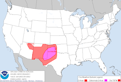
Particularly Dangerous Fire Wx - High Wind Event Today!
Click On The Maps To Enlarge Them.
Potential For A Dangerous And Life Threatening Fire Weather Event!
Today's weather across Southeastern New Mexico and parts of West Texas just looks downright scary. A High Wind/blowing dust event will combine with the exceptionable drought conditions, relative humidity values today down to near zero, and afternoon high temps in the 90's, to create Potentially Dangerous and Life Threatening Fire Weather Conditions across the local area!
An unusually strong late spring upper-level storm will swing across the area today and tomorrow. As has been the case since last fall, this system is bone dry, but is locked and loaded to produce high winds across the area. Today could be one of those days that go down in the history books, if wild fires break out across the area.
A High Wind Warning remains in effect for the Guadalupe Mountains for southwesterly to westerly winds sustained at around 40-55 mph with gusts near 75 mph today into this evening.
A Wind Advisory will be in effect for Eddy and Lea Counties for today into early this evening. Southwest to west winds are forecast to become sustained at around 30-40 mph with gusts over 50 mph later this morning, and will persist into early this evening. A few areas may experience wind gusts closer to 60 mph. A High Wind Warning is not out of the question for parts of the local area later today.
A High Wind Warning is now in effect for Chaves and Lincoln Counties for southwest to west winds sustained at around 30-40 mph with gusts near 60 mph. A Wind Advisory is now in effect for Otero County for southwest to west winds sustained at around 25-35 mph with gusts to near 50 mph.
Update at 8:00 AM MDT-
A High Wind Warning is now in effect for Chaves and Lincoln Counties for southwest to west winds sustained at around 30-40 mph with gusts near 60 mph. A Wind Advisory is now in effect for Otero County for southwest to west winds sustained at around 25-35 mph with gusts to near 50 mph.
Areas of blowing dust will also develop over parts of the local area by noontime. Sudden drops in the visibility down to near zero with little or no advanced warning will be possible. This will be especially true in the more dust prone locations such as: freshly plowed or exposed farmland, open fields and lots, and construction sites.
Red Flag Warnings are in effect for all of SE NM and W TX today. Extremely Critically Dangerous Fire Weather Conditions will exist today with the potential for a Regional Fire Weather Outbreak over parts of the area. Any wild fire that should accidentally develop today will have the potential to rapidly spread and grow in the high winds, and may threaten life and property. Please refrain from any type of outdoor activity that involves the use of sparks or flame.
------------------------------------------------------------------------------
Click On The Map To Enlarge It.
Regional Outbreak Of Severe Weather!
(North Texas-Most of Oklahoma-Kansas-Parts of Arkansas)
Most of the areas mentioned above are in the Moderate to High Risk category for severe weather today and this evening. A Regional Outbreak of Severe Weather may occur in these areas today...with the potential for a few long track, large and violent tornadoes.
Given the destructive and deadly nature of this springs severe weather outbreaks...it would be extremely wise for anyone living in the mentioned areas above, to be prepared for the worst that mother nature has to offer today and tonight.
Please pay very close attention to, and heed all of your local National Weather Service Watches and Warnings concerning this event. Stay tuned to NOAA Weather Radio, or your favorite media outlets, for the very latest information concerning this potentially deadly outbreak of severe weather today and tonight!
The Truth Is Stranger Than Fiction!


Comments
Post a Comment
Your comments, questions, and feedback on this post/web page are welcome.