Summer Heat To Continue!
July 14th, 2018.
Low clouds hugging the mountains after the rains near Wimsatt.
Continued Hot Into Monday Then Brief Relief.
(Monday, July 23, 2018.)
European (ECMWF) Model Temperature Anomalies.
(At 6 PM MDT Monday, July 23, 2018).
Regional Temperature Anomalies.
(At 6 PM MDT Monday, July 23, 2018).
European (ECMWF) Model High Temp Forecast.
(Monday, July 23, 2018.)
NWS NDFD Forecast High Temps.
(Monday, July 23, 2018).
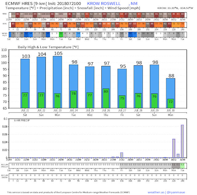
Our recent run of blistering summer heat will continue right into Monday. Brief relief (a relative term for sure) is forecast to occur Monday night into the middle of next week as a weak cold front pushes south and west down the Eastern Plains. Our high temps are forecast to drop down into the mid to upper 90's...down from the 100º to 107º we've been experiencing.
Rain? Maybe In The Mountains.
(Valid Today - 6 AM MDT Wednesday, July 25, 2018).
GFS Total Rainfall Forecast.
(Valid Today - 6 AM MDT Wednesday, July 25, 2018).
WPC Total Rainfall Forecast.
(Valid Today - 6 AM MDT Wednesday, July 25, 2018).
Model forecasts continue to hint that the best chances locally for seeing any meaningful rainfall through next Wednesday will be over and near the mountains. Thunderstorms are forecast to fire up along and behind the approaching weak cold front Monday night into Tuesday. There is the possibility that some of these storms may reach the Southeastern Plains but our chances of that happening are pretty slim. This mornings run of the GFS model offers the best hope for rain over Chaves and Lincoln Counties as well as across the Eastern Plains.
(July 21st).
(July 21st, 1983).
July 21st, 1983 - The lowest natural temperature ever directly recorded at ground level on Earth is −89.2 °C (−128.6 °F), which was at the Soviet Vostok Station in Antarctica, occurred on this day. Analysis of satellite data indicated a probable temperature of around −93.2 °C (−135.8 °F), also in Antarctica, on August 10, 2010; however, this reading was not confirmed by ground measurements.
The Truth Is Stranger Than Fiction!


Comments
Post a Comment
Your comments, questions, and feedback on this post/web page are welcome.