Unusual For November - Severe T-Storms/Heavy Rains/Flash Flooding!
Alamo Peak South Of Cloudcroft, NM.
Severe t-storms, heavy rainfall, and a flash flood threat tonight through Saturday across the southeastern plains. The Sacramento mountains will see snow developing Sunday into Monday. Another round of winter weather for the state late next week.
ECMWF 500 MB (18,000' MSL) Forecast.
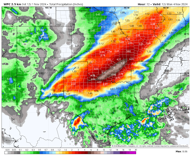
Weather Prediction Center (WPC) Storm Total Precipitation Forecast.
NWS NDFD Storm Total Snowfall Forecast.
Valid Today Through 5 AM MST Monday, November 4, 2024.
Unusual For November - Severe T-Storms/Heavy Rains/Flash Flooding!
The last thing that the residents of Roswell and surrounding areas want to hear is that another round of severe thunderstorms along with a flash flood threat is on the way. Not just for the Roswell area but all of southeastern and parts of eastern New Mexico. Severe weather and flash flooding are fairly uncommon in November but not totally unheard of.
At the surface, the cold front that has produced much cooler temps and the first freeze of the season for much of New Mexico will back to the north this afternoon and evening as a warm front. Meanwhile, a large and deep upper-level longwave trough of low pressure with multiple shortwaves embedded within it will continue to dig southward today through the weekend.
A strong upper-level closed low will form over Arizona on Sunday. This storm will then slowly move eastward into southwestern New Mexico Monday morning, and then eastward into far southeastern New Mexico by sunset Monday.
Today low-level moisture will increase as surface winds turn southerly and southeasterly which will help Gulf of Mexico moisture surge northwestward into the area. A strong dryline will set up along the Guadalupe, Sacramento, and Capitan mountains. This dryline as well as the northward-moving warm front will be the focus for thunderstorms this evening into Saturday morning.
Some of these thunderstorms will become severe late this afternoon but more so this evening. Continuing into Saturday morning. Another round of severe thunderstorms will be possible again Saturday afternoon and evening.
A couple of lines of thunderstorms may develop with slow-moving training thunderstorms embedded within them. There will also be the potential for back-building thunderstorms. Later tonight, a large complex of thunderstorms may evolve called a mesoscale convective system (MCS).
Large hail, damaging thunderstorm wind gusts in excess of 58 mph, frequent cloud-to-ground lightning, heavy rainfall, and flash flooding all will be possible with any thunderstorm that develops.
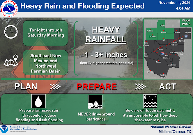
Of particular concern will be the training and back-building thunderstorms, which have the potential to produce multiple rounds of heavy rainfall. This could lead to flash flooding in those areas covered under the Flood Watch: Eddy, Lea, Chaves, Roosevelt, and Curry Counties as of 8 AM MDT this Friday morning.
The stronger thunderstorms may produce rainfall rates of 1"-2" per hour. Storm total rainfall amounts from tonight into Monday morning could be in the 1" to 3" range with locally higher amounts.
Round two comes Saturday with a Slight Risk Outlook covering far southeastern New Mexico in southern Lea County. The severe weather and heavy rain threats will shift eastward into the far eastern Permian Basin and central Texas on Sunday.
Southwesterly winds will become gusty Sunday afternoon over the local area with gusts in the 25 to 40 mph range. Areas of blowing dust may be a concern over parts of southern New Mexico on Monday.
As is usually the case with these types of setups there may be changes in our local forecasts so be weatherwise and stay up to date with current conditions and forecasts today through Monday. Some areas may get more rain than currently forecast and some less.
Sacramento/Capitan Mountains Snowfall.
Scattered thunderstorms will dot the Sacrament, Capitan, and Guadalupe mountains tonight into Saturday. As the storm draws closer another round of rain showers and thunderstorms will develop on Sunday. Rain showers will mix with and change over to snow across the Sacramento and Capitan mountains Sunday night with snow levels lowering to around 6,000' to 7,000'.
Current forecasts indicate that the Sunspot, Cloudcroft, and Silver Lake areas may get 1" to 3" of snow out of this storm by Monday night. Ski Apache may get more than this depending upon the storm track. At this time any snow that may accumulate in the Ruidoso area looks to be an inch or less. However, these totals could change depending on how the storm tracks over the state. If it takes a more northerly course then less snow would fall for the Sac's. A more southerly track would mean more snow for the Sac's.
.KEY MESSAGES...
Updated at 550 AM MDT Fri Nov 1 2024

 - Locally heavy rainfall, flash flooding, and strong to severe
   storms are possible in eastern and southeastern NM late Friday
   through mid-day Saturday.

 - A storm system will bring colder temperatures and the first
   noteworthy snow of the season to the northern and western
   mountains Sunday through Monday.

 - A colder storm system may impact the region late Wednesday
   through Friday, bringing more widespread precipitation with
   lower snow levels.
There Are None So Blind As Those Who "Will - Not" To See...107.


Comments
Post a Comment
Your comments, questions, and feedback on this post/web page are welcome.