Weak Monsoon Means Widely To Scattered T-Storms & Slightly Cooler Temps.

August 4, 2025. 
Lea County Sunset.
Halfway Between Carlsbad & Hobbs.

Low temperatures across New Mexico this morning were above normal in many places. Numerous locations in southern, eastern, and southeastern New Mexico reported overnight lows in the 70's. While the Angel Fire Airport ASOS reported a chilly low of 34. 

Friday afternoons highs were once again hot underneath a stout upper-level ridge of high pressure that has been centered over the state. The Roswell Airport ASOS reported a high of 106, which was one degree short of their record high for the date of 107 in 2011.

Heat Advisories are in effect today for Chaves County and Central New Mexico. Heat Advisories are also in effect today for parts of southern New Mexico (Deming and El Paso areas).  

Forecast high temps will be similar to yesterday's readings statewide this afternoon. A slight cooling trend is forecast for the area starting Sunday, continuing into the middle of next week. A weak cold front will slide slowly southward down the northeastern and eastern plains Sunday into Monday. Highs Monday and Tuesday across these areas will be some ten to fifteen degrees cooler than yesterday's and today's highs.

A weak surge of monsoonal moisture is working its way northward into most of the state west of the central mountain chain. Deeper monsoonal moisture will continue filtering northward into at least the middle of next week. 

Meanwhile, the unusually strong (record-setting, actually) upper-level ridge of high pressure that has been camped out overhead for the last week will continue breaking down and shifting westward to California next week as an upper-level trough of low pressure moves southward into the area.

A weak cold front will backdoor southward and westward into the northeastern plains Sunday and into eastern and southeastern New Mexico on Monday. Low-level moist easterly upslope flow will accompany the frontal passage along with cooler temps.

All said and done, our chances for widely scattered t-storms across southeastern New Mexico go up starting this afternoon, continuing into the middle of next week. The Guadalupe, Sacramento, and Capitan mountains have the best chances for scattered t-storms this weekend into next week. Locally heavy rain from slow and erratic-moving t-storms may produce isolated cases of localized flash flooding. 

The rest of the state will see widely scattered to scattered afternoon and evening t-storms today into next week, with the best chances for getting wet and the heaviest rains expected over and near the mountains. Western and northwestern New Mexico will be the least favored areas for t-storms and rain showers. 

Burn scar flash flooding will once again be a possibility this weekend into next week, especially over and near the Hermits Peak/Calf Canyon and Ruidoso burn scars. A few incidences of localized flash flooding outside of the burn scars will be possible elsewhere across the state associated with the strongest t-storms and heaviest rains next week. 

A Marginal Risk for scattered severe t-storms will exist today into this evening across parts of northeastern and eastern New Mexico. Large hail, damaging t-storm wind gusts, and frequent cloud-to-ground lightning will be the main severe weather threats. 

On a side note, the Pacific Decadal Oscillation (PDO) Index reached an all-time record 170-year low of -4.0 this past July. 

Negative PDO's typically lead to overall warmer and drier than normal temperatures and precipitation for New Mexico. Indications are that La Niña conditions will return this fall and winter as well. This is not good news and may mean another warm, very dry, and windy winter and spring. And possibly a worsening or continuation of our ongoing severe to extreme drought. 

Our last long-lived negative PDO started in the mid-1940s and ended in the mid-1970s. This was a very dry period for New Mexico. The eight to ten-year drought that ended in 1958 was worse than the Dust Bowl drought in southeastern New Mexico.

Then the PDO flipped to a warm or positive phase, and some of our wettest years on record occurred from 1976 through 1997. The eastern Pacific PDO has been in a negative phase since 1998. Some of our worst winter and spring dust storms have plagued the area since 2,000, and recently over the past couple of years. 

Interestingly enough, some of our coldest winter temperatures also occurred during this period (negative PDO). 1962 and 1963 were very cold, with Roswell dropping down to -24 on January 11, 1962. And Artesia down to -20 to -24 on January 11, 1962. 

Eagle Nest bottomed out at -47 on January 11, 1962, and again on January 6, 1971. Red River recorded a bone-chilling -40 on January 13, 1963. On February 1, 1951, Gavilan located in Rio Arriba County, recorded the lowest official temperature in the state with an arctic-like -50. 

Many other factors control New Mexico's weather, so this isn't a given, but it is rather alarming to see such a record-low index. One group believes that the PDO bottoms out (negative values) in 2026 and then flips back to a warm phase again after that. Time will tell.  


Valid At 6 AM MDT Saturday, August 9, 2025. 

GFS 500 Millibar (18,000' MSL) Forecast.

Valid At 6 PM MDT Sunday, August 10, 2025.


Valid At 6 AM MDT Monday, August 11, 2025. 


The Pacific Decadal Oscillation (PDO) is often described as a long-lived El Niño-like pattern of Pacific climate variability (Zhang et al. 1997). As seen with the better-known El Niño/Southern Oscillation (ENSO), extremes in the PDO pattern are marked by widespread variations in the Pacific Basin and the North American climate. In parallel with the ENSO phenomenon, the extreme phases of the PDO have been classified as being either warm or cool, as defined by ocean temperature anomalies in the northeast and tropical Pacific Ocean. When SSTs are anomalously cool in the interior North Pacific and warm along the Pacific Coast, and when sea level pressures are below average over the North Pacific, the PDO has a positive value. When the climate anomaly patterns are reversed, with warm SST anomalies in the interior and cool SST anomalies along the North American coast, or above-average sea level pressures over the North Pacific, the PDO has a negative value (Courtesy of Mantua, 1999).

The NCEI PDO index is based on NOAA's extended reconstruction of SSTs (ERSST Version 5). It is constructed by regressing the ERSST anomalies against the Mantua PDO index for their overlap period, to compute a PDO regression map for the North Pacific ERSST anomalies. The ERSST anomalies are then projected onto that map to compute the NCEI index. The NCEI PDO index closely follows the Mantua PDO index.

Are We Due For A Cycle Change Of The Pacific Decadal Oscillation?


Executive summary: The cool cycle of the Pacific decadal oscillation has strengthened during recent years and will reach 30 years in duration if continued through 2026 as forecast by the Climate Impact Company constructed analog prediction. The 30-year duration matches the previous longest cool cycle observed during the middle 1940’s to middle 1970’s. Are we due for a long-term cycle change of the PDO? The question is made complicated by the warming of the mid-latitude oceans accelerating during recent years.

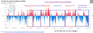
Fig. 1: The Pacific decadal oscillation index and cool/warm cycles.

Discussion: The Pacific decadal oscillation (PDO) is a leading mode of climate variability well-correlated with western North America precipitation patterns and a general link to phase of El Nino southern oscillation (ENSO). When the cool phase (-PDO) is present, the Northwest U.S. is generally wetter than normal while a drier than normal climate is common in this region during the warm phase (+PDO). Generally (not always), -PDO is accompanied by La Nina while +PDO is present during El Nino. The PDO/ENSO combination represents a powerful influence on North America climate. The PDO cycle changes every 15-32 years, based on observations since the late 1800’s (Fig. 1). Currently, the -PDO cycle continues and is approaching 30 years in length (almost) matching the middle 1940’s to middle 1970’s -PDO cycle which is the longest on record. Are we about to witness a PDO cycle change?

Modern-day -PDO is much different from our historical understanding of the North Pacific SSTA regime that causes PDO phase. Normally -PDO is produced by cooler than normal SSTA in the Northeast Pacific while the northwest Pacific is much warmer than normal (Fig. 2). However, “new” -PDO is much different. The northeast Pacific is warmer than normal, similar with a +PDO regime. However, waters near the Dateline to East Coastal Asia are record warm and the anomaly comparison renders -PDO (Fig. 3). In fact, the “new” -PDO of this decade may be the strongest on record fueled by the record warmth of the northwest Pacific basin. The warmer Northeast Pacific waters during the strong -PDO of this decade have caused the Northwest U.S. to turn much drier compared to the wetter “old” -PDO.

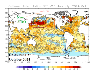
Fig. 2-3: An example of the North Pacific SSTA regime during “old” versus “new” cool phase of the Pacific decadal oscillation.

The Climate Impact Company PDO constructed analog forecast through 2026 indicates the cool phase continues in 2025, weakens during early 2026, and regains strength later next year (Fig. 4). The continuing -PDO is fueled primarily by very warm waters near and west of the Dateline while the ocean surface in the northeast Pacific is less anomalous warm. Consequently, the prevailing climate across western North America is closer to the historic +PDO character (warm and dry bias) versus wet and cool conditions associated with the “old” -PDO. The analog forecast does not suggest a cycle change through 2026 which brings the current cool cycle to 30 years. A cycle change to the warm phase is likely reliant on the West Pacific cooling off.

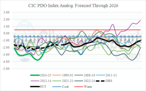
Fig. 4: The Climate Impact Company constructed analog forecast of PDO index through 2026.

Summary: The character of -PDO has changed. The influence of “new” PDO has similarities to +PDO climatology in North America whereas the Northwest U.S. is drier and warmer than typical -PDO climate. The reason is the relative (much) warmer waters near and west of the Dateline. The current -PDO cycle should be nearing an ending based on climatology. However, a cycle change to the positive phase is likely dependent on cooling of northwest and central North Pacific. The warming oceans, accelerating during recent years, has caused the PDO character change.

There Are None So Blind As Those Who "Will - Not" To See...107.

Comments

  1. That's very interesting on changes in how the PDO climatology is measured. As always, a great, unbiased report on the weather and relationship to the climate. Rare today. Thanks again!

    ReplyDelete

Post a Comment

Your comments, questions, and feedback on this post/web page are welcome.

Ruidoso Live Webcam

Cloudcroft Live Webcam

Roswell Live EarthCam

Current US Hazardous Weather Watch/Warning Map

New Mexico

Chaves County Plains & Mtn's

Eddy County

Culberson County

Lea County

Lincoln County

Otero County

Average Daily High/Low Temperatures & Rainfall/Snowfall