Very Hot For The Next Week.
Click On The Maps To Enlarge Them.
Upper-Level Ridge Firmly In Control.
Take a look at the first map above, it depicts the 500 MB (roughly 18,000' MSL) analysis at 6 AM this morning. The mid-upper level ridge of high pressure is firmly anchored over Texas and Mexico. The second map depicts the forecast position of the ridge by Sunday evening.
Notice that there is not much change in the positioning of the ridge. If anything it is forecast to strengthen and expand in coverage. As long as the ridge is centered over, or close to SE NM and W TX, there isn't a whole lot of hope for relief from the heat. Nor will there be any meaningful break to the extreme drought conditions we are currently suffering under.
Wednesday's High Temperatures.
West Texas-
Rio Grande Village Climate 113
Castolon Climate 111
Lajitas Climate 110
Presidio Climate 108
Pecos, TX Arpt 108
Wink, TX Arpt 108
Big Springs, TX Arpt 106
Midland, TX Intl Arpt 105
Andrews, TX Mesonet 105
Snyder, TX Mesonet 105
Seminole Climate 105
Crane Climate 105
Lamesa Climate 104
Sanderson Climate 102
Van Horn Climate 101
SE New Mexico-
Jal Climate 106
Paduca Raws Near Wipp 106
Carlsbad Arpt ASOS 105
Carlsbad Climate 104
2.1 NNW Downtown Carlsbad 104
Roswell Arpt ASOS 103
8-Mile Draw Raws 102
Artesia Climate 102
Hobbs Climate 102
Tatum Climate 102
Caprock Raws 101
Hobbs - KM5BS 101
Artesia Arpt AWOS 100
Bat Draw Raws 98
McKittrick Canyon Raws 96
Guadalupe Pass ASOS 95
Dunken Raws 92
Queen Raws 91
Pinery Raws 91
Weed - Dark Ridge Observatory 87
Dog Canyon Climate - SW Of Queen 86
Ruidoso Climate 85
Mayhill Raws 85
Cosmic Raws - Sunspot 78
Cloudcroft Climate 77
Temperature Data Is Courtesy Of-
---------------------------------------------------------------------------
Click On The Maps To Enlarge Them.
IR Satellite Image Of Hurricane Adrian At 11:15 AM MDT,
Thursday, June 9, 2011.
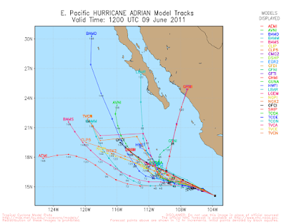
Some of the long-range computer models still want to try and bring some of the remnant mositure from Hurricane Adrian northward into Northern Mexico, and perhaps into the Texas Big Bend Region next week. Will this happen and will any of this moisture get drawn northward into SE NM & W TX? Still a tough question to answer. I'm still hoping it will.
The Truth Is Stranger Than Fiction!


Comments
Post a Comment
Your comments, questions, and feedback on this post/web page are welcome.