Posts

Showing posts from July, 2013

Why Are My Weather Posts Missing From Facebook.

Hello everyone. I just wanted to let you know that my Facebook page was shut down without any warning by Facebook this past Saturday, June 8th. All I was told was that I had violated their community standards. I don't know what triggered that; they didn't tell me. I was told this may be permanent or for six months.
My guess is that it may be because I posted several comments and articles from my Substack page about the riots in LA, and that must have triggered/angered someone, and they complained, thus Facebook shut me down. I don't know this as fact, though. I have appealed this decision, and I'm still waiting for their reply. I have read on X that this has happened to other Facebook users posting about the LA riots as well.
I always share my weather blog posts (that I post here) on my Facebook page and my X page. This included over twelve different New Mexico and West Texas Facebook Community sites. So there are thousands of you out there (based on my views and shares of those posts) who will no longer see those posts. My Facebook page may or may not be restored.
This is another good reason (as the National Weather Service often reminds us) to have multiple ways of receiving severe weather alerts when severe weather threatens your location. My weather web page is one of those ways, and I really appreciate all of you who have and still do use it. Thank you so much!!!
If my Facebook page is restored, I will continue to share my weather blog posts and some of the NWS Watches and Warnings...as I have been doing for years now.

Rainbows & A Fiery Sunrise.

Image
Another example of being in the right place at the right time.  I do admit that I love my Cannon EOS Rebel T3i. The Truth Is Stranger Than Fiction!   My Web Page Is Best Viewed With Google Chrome.

Preliminary July 2013 Rainfall Totals For SE NM.

Image
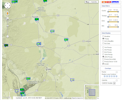
Click On The Maps & Tables To Enlarge Them. Preliminary July Rainfall Totals & Anomalies. Shared From The Albuquerque NWS Facebook Page. Preliminary New Mexico Mesonet  July 2013 Rainfall Totals. Preliminary CoCoRaHs  July 2013 Rainfall Totals. Chaves County. Eddy County. Lea County. Lincoln County. Otero County. Preliminary NWS Co-Op Stations  July 2013 Rainfall Totals. Roswell, NM. Artesia, NM. Carlsbad, NM. Carlsbad Airport. Hobbs, NM. Tatum, NM. Capitan, NM. Ruidoso, NM. Elk, NM. Cloudcroft, NM. NWS Climate Co-Op Data Is Courtesy Of- Midland NWS Office El Paso NWS Office Albuquerque NWS Office Although we still have two more days until we close out the books on this months rainfall totals, I have listed the preliminary totals above. Its been a good month rainfall-wise for the area. As is usua...

Heating Up This Week With 100+ Temps.

Image
This Mornings 12Z/6 AM MDT WRF/NAM Temp Forecast.  Valid At 4 PM MDT Tuesday. NWS Forecast For Carlsbad, NM. Our recent rains have been nice...actually a blessing, and going a long way to at least put a dent in the drought temporarily. I picked up another .11" yesterday here at my home in Carlsbad, NM. This brings my July total up to 5.37" , and my YTD total up to 9.38" . A CoCoRaHs Observer in Queen, 50 miles west-southwest of Carlsbad, in the Guadalupe mountains has measured 9.55" so far this month.  We will undergo a change this week as we dry out and heat up. Its been muggy, and with our forecast high temps expected to climb up above 100F tomorrow into Saturday, its going to feel really hot and muggy! The Truth Is Stranger Than Fiction!   My Web Page Is Best Viewed With Google Chrome.

Skline Campground - Monjeau Lookout One Year After The Little Bear Fire.

Image
My wife Diane, and I, took a drive yesterday to the Sacramento mountains. Thankfully the Pecos Valley and nearby areas are finally starting to green up with the recent rains. We ended up at the Skyline Campground, which is located next to the Monjeau Lookout , northwest of Ruidoso, NM. One year later the grasses and bushes have grown back in full force after last years Little Bear Fire. But its evident that the area will take many years to fully recover...especially the trees. Click here to see a video shot from the Monjeau Lookout Tower last year right after the fire.  The Truth Is Stranger Than Fiction!   My Web Page Is Best Viewed With Google Chrome.

Rains Return To SE NM.

Image
Click On The Maps To Enlarge Them. 24-Hour Rainfall Totals As Of 6 AM MDT. Maps Courtesy Of  The NWS Mesonet Observations. GRLevel3_2.00 Dual Pol Radar.  Estimated Storm Total Rainfall Amounts. Thunderstorms returned to southeastern New Mexico yesterday afternoon and evening. Some of these have persisted until sunrise this morning. I only managed to pick up .01" here at my home in Carlsbad.  The Truth Is Stranger Than Fiction!   My Web Page Is Best Viewed With Google Chrome.

NWS Albuquerque Burn Scar Matrix

Current National Weather Service Watches/Warnings In Effect.

New Mexico

Chaves County Plains & Mtn's

Eddy County

Culberson County

Lea County

Lincoln County

Otero County

Current US Temps

Current US Wind Chill/Heat Index Temperatures

WPC 7-Day Precipitation Forecast

Roswell Live EarthCam

Ruidoso Live Webcam

Cloudcroft Live Webcam

NWS Midland 3-Day Precipitation Forecast

NWS Midland 3-Precipitation Chances

New Mexico 3-Day Precipitation Forecast

New Mexico Precipitation Chances

NWS El Paso 3-Day Precipitation Forecast

NWS El Paso Precipitation Chances

US 24-Hour Precipitation Forecast

US 3-Day Precipitation Forecast