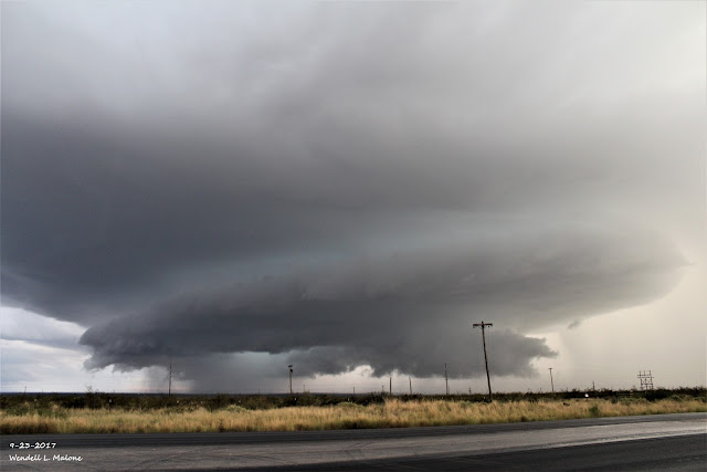
Supercell Thunderstorms Roam The High Desert Saturday.
Blog Updated At 8:10 PM MDT.
Looking Southeast From Whites City At 6:26 PM MDT Saturday, Sept 23, 2017.
My wife jumped into the truck and headed southwest to Whites City Saturday afternoon to chase this supercell thunderstorm pictured above. As impressive as this storm was when I shot this photo it was even more so on radar before we got down there. It had formed a wall cloud but we didn't notice any significant rotation when I took this photo. The storm had already begun to weaken.
GRLevel2 Radar Snapshot Of This Supercell Thunderstorm At 5:15 PM MDT.
The El Paso/Santa Teresa NWS Office had warned on it for tennis ball size hail shortly before it rolled over the top of the Guadalupe Mountains National Park. At 5:20 PM MDT the Hudspeth County Sheriff reported power lines downed from the storm in Dell City.
GRLevel3_2.00 Radar Snapshot At 6:07 PM MDT,
The Midland NWS Dual Pol Doppler Radar was indicating that the hail core aloft in the storm had reached 3.50" at the time I grabbed this snapshot. Strong mid level rotation was also noted. We were just south of the Carlsbad Airport at the time headed to Whites City. It was raining on us so it was hard to make out the storm details looking southwest into the front of the storm.
GRLevel3_2.00 Radar Snapshot At 6:31 PM MDT,
Here this severe thunderstorm had started making a right turn as it was entering Whites City. At 6:27 PM MDT we were sitting on the side of the road taking photos of the storm (see pic above) when hail started falling on us (pea to penny size). I didn't want to core punch this one with radar indicating very large hail so we turned around and headed north towards Carlsbad. Blinding sheets of rain and 50 mph wind gusts greeted us as we turned east on Black River Village Road. We turned around agiin and headed back to town in sheets of rain that was knocking the visibility down to around a 1/4 of a mile.
GRLevel3_2.00 Radar Snapshot At 6:07 PM MDT.
I grabbed this Storm Relative Velocity (SRV) snapshot which shows the rotating couplet (green on red) southwest of Whites City. I wish we had left town a little earlier and we might have seen at least some decent rotation in the wall cloud.
GRLevel3_2.00 Radar Snapshot At 6:26 PM MDT.
This Storm Relative Velocity (SRV) snapshot at 6:26 PM MDT shows that the rotation within the supercell thunderstorm was weakening southeast of Whites City at the time I took the photo above.
Updated At 9:45 AM MDT This Morning.
Large Hail & Damages Near The NM/TX State Line Saturday Afternoon.
While I was pranked by my co-worker (see the comments below) about the large hail at the Hidalgo Gas Plant west of Orla, TX yesterday the photos above are real. Gail Carter in Carlsbad a friend of mine on Facebook sent me these photos this morning.
They are courtesy of Kendra Mayes, Tylar Colwell, and Donna Lewis. The photos were taken at the Lewis home north of U.S. Highway 62/180 near the New Mexico/Texas state line Saturday afternoon. I'm still working on getting the exact details of the storm as far as the time and location goes. Tylar Colwell is the grandson of Kendra Mayes, Donna Lewis is the Kendra's daughter and the mother of Tylar. They have lived at this location for 43 years and say that yesterday's hailstorm and high winds (estimated to be at least 70 mph) were the worst they have ever seen according to Gail.
Hail - Wind Damage -Flash Flood Damage.
Tylar Colwell sent me the photos above this afternoon. They were taken on their ranch a couple of miles north of the the New Mexico/Texas State line and north of U.S. Hwy 62/180. Hail stripped the vegetation Saturday afternoon around 6:15 PM MDT including the bark and leaves off of mesquite bushes. I've only seen this happen in SE NM a couple of times in my lifetime and I will be 60 next spring. These photos were taken in and near the XT Draw. As of this afternoon they hadn't found any livestock killed by the hail.
Please Note:
I have removed the pictures from the Hidalgo Gas Plant of the tennis ball size hail that I posted earlier this morning on this blog. My co-worker Hank Pitre at the Hidalgo Gas Plant (located 18 miles west of Orla, TX in northern Culberson County) called me this morning and told me that the pictures were a prank and fake. They have been deleted from my Facebook Page and Twitter Page as well.
The damage to the Forklift folder was not caused by the hail but by being run over by the forklift. The picture of the hail was downloaded from the internet and was not from yesterday's hailstorm at the plant. I am so sorry for this folks and you have my sincere apologizes. Apparently some people think that severe weather is funny.
My sincere apologizes to the Midland National Weather Service Office as well. I found out about this at 8:59 AM MDT this morning. I promise you that I would never intentionally lie about severe weather and post something knowingly false. It won't happen again!
Two inches of rain (1.96") drowned the plant also.
The Truth Is Stranger Than Fiction!


Comments
Post a Comment
Your comments, questions, and feedback on this post/web page are welcome.