Here Comes The Rain & Cooler Temps!
Valid Today Through Next Friday Morning Sept 29, 2017.
NWS NDFD Rainfall Forecast.
Valid Today Through Sunday At 6 PM MDT.
GFS Rainfall Forecast.
Valid Today Through 6 PM MDT Monday.
GFS 500 MB (18,000' MSL) Forecast.
Valid At 6 PM MDT Sunday.
Here Comes The Rain!
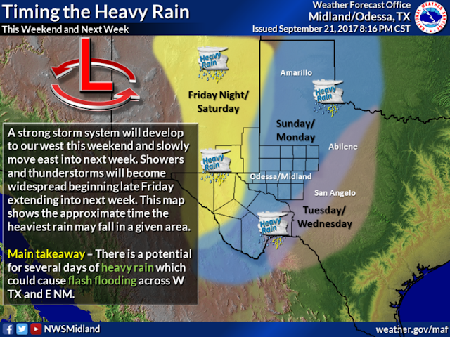
A deep and cold mid and upper level trough of low pressure now dropping southward from northern Nevada and southwestern Idaho will continue to work its way towards the Four Corners Region into this weekend. This trough of low pressure will produce significant changes in our weather across the Southwestern States today into next week. A much cooler and wetter pattern is slated for New Mexico especially east of the mountains and across West Texas. In fact it will be cold enough in northern Arizona Sunday morning for frost above 6,500' across the Mogollon Rim.
There is a Marginal Risk for a few Severe Thunderstorms across the Eastern and Southeastern Plains of New Mexico, and parts of West Texas this afternoon and evening. Large hail and damaging thunderstorm wind gusts in excess of 60 mph will be possible.
More importantly a pattern of much wetter weather will start this afternoon and continue into next week. Scattered thunderstorms are forecast to develop across the local area this afternoon and continue into the weekend. These thunderstorms will be capable of producing heavy rainfall and flash flooding. Particularly on Saturday into Sunday morning.
Storm total rainfall amounts for Southeastern New Mexico by Monday morning are currently forecast to be in the 1" to 2" range with some locals seeing 2" to 4". A few locations may even see more than this by the end of next week especially if "training thunderstorms" develop. This just means that one thunderstorm behind another for hours on end may move over any one location producing very heavy rainfall that may cause flash flooding.
Overall our temperatures will cool down this weekend into next week. Highs today will still be in the low to mid 90's, the 80's Saturday into Monday, and then dropping down into the 60's and 70's Tuesday into Thursday behind a strong cold front that will move southward through the local area Monday night into Tuesday.
The Truth Is Stranger Than Fiction!


Comments
Post a Comment
Your comments, questions, and feedback on this post/web page are welcome.