First Look At Our Christmas Weather.
Our Charlie Brown Christmas Theme This Year.
Christmas Weather Outlook.
Today.
Our afternoon high temperatures yesterday ranged from 64º in Roswell and the Sierra Blanca Regional Airport to a balmy 74º at the Carlsbad Airport. Today's highs will be a few degrees warmer which will be some 15º to 20º above normal for the date.
Sunday.
A dry cold front will move through the area tonight and this will drop our high temperatures on Sunday down some 20º to 25º below today's readings. Thus our highs on Sunday will end up being close to only a couple of degrees below normal for the date.
Christmas Eve.
Christmas Eve will be warmer than normal (temps will be some 5º to 15º above normal) with highs ranging from the low to upper 60's.
Christmas Day.
Christmas Day will see highs in the low to mid 60's which will be 5º to 10º above normal.
No White Christmas This Year.
Valid At 5 PM MST Christmas Evening.
US GFS Storm Total Snowfall Forecast.
Valid At 5 PM MST Christmas Evening.
US GFS Snow Depth Forecast.
Valid At 5 PM MST Christmas Evening.
European (ECMWF) 500 MB (18,000') Forecast.
Valid At 5 PM MST Christmas Evening.
Canadian (GEM) 500 MB (18,000') Forecast.
Valid At 5 PM MST Christmas Evening.
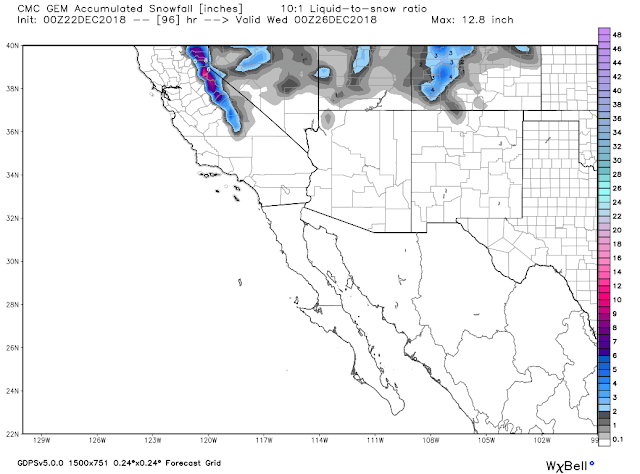
Canadian (GEM) Storm Total Snowfall Forecast.
Valid At 5 PM MST Christmas Evening.
A cold and very strong upper level trough of low pressure will drop southward out of the Pacific Northwest beginning tomorrow. By Christmas Eve at sunset this next winter storm to impact the area will be starting to close off over northern California as it continues digging southward. By sunset on Christmas a strong upper level closed low will be located over Arizona. The models currently disagree just exactly where but no doubt a potent winter storm is will shaping up to impact our weather beginning Christmas night and continuing into next weekend.
Locally our Christmas Day weather will be warm and perhaps a bit breezy. By Christmas night rain showers and mountain snow showers will begin overspreading western and northern New Mexico. Snow levels are forecast to lower Christmas night into Wednesday as the first winter storm moves through.
Interestingly enough a weak dry line may shape up across West Texas Christmas Eve night as the low level jet increases to around 50 knots and strong lift and instability associated with the approaching strong closed low nudge closer to the area. Thunderstorms may be possible across parts of West Texas.
Current thinking is that we will have a break next Thursday with the next stronger and colder upper level low to impact the state and area next Friday into next weekend. The models are currently getting pretty excited about much of the state seeing accumulating snowfall by next Sunday. The trend going forward is for much colder and stormier weather to impact the state and local area More on this later.
US GFS Storm Total Snowfall Forecast.
US GFS Storm Total Snowfall Forecast.
Valid At 5 PM MST Sunday, December 30th, 2018.
The European (ECMWF) forecast model has a similar forecast but with heavier and more widespread snowfall.
(As Of December 21st).
Our chances of seeing 1" of snowfall on the ground or a White Christmas every year are low. Roswell and Artesia has about a 7% chance, Carlsbad 1%, and the Ruidoso and Cloudcroft area about a 15% to 20% chance.
I will publish a history review of our local Christmas Eve and Christmas Day weather extremes tomorrow.
The Truth Is Stranger Than Fiction - And Sometimes It Hurts!


Comments
Post a Comment
Your comments, questions, and feedback on this post/web page are welcome.