Posts

Showing posts from May, 2020

Not Much Hope For Meaningful Rainfall Anytime Soon.

Image
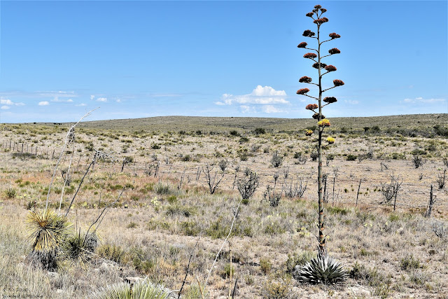
5-30-2020. West Of Hope, NM Looking West. Our Century Plants (Agave) Are In Bloom. Wet February & March - Bone Dry Since. Today (Sunday, May 31st) marks the last day of the meteorological spring. Therefore Monday will be the first day of the meteorological summer. Here at our home in Carlsbad, New Mexico I only recorded a trace of precipitation during April and also in May. February was wetter than normal with a monthly precipitation total of .77". March saw 1.77" which is way above normal and the wettest March at our home in the past 13 years. After that its been bone dry with no significant relief or hope in sight for meaningful rainfall. New Mexico Drought Status. As Of May 26th, 2020. As Of May 28th, 2020. New Mexico Drought Status. New Mexico's drought conditions continue to slowly worsen over much of the state, especially over the northern, central, and eastern areas. Long-range forecasts for June and the summer (June

Cold Front Early Memorial Day Knocks Our Highs Down Into The 60's To Near 70.

Image
Visible Satellite Image.  At 5:06 PM MDT Saturday, May 24, 2020. Once again scattered to numerous severe thunderstorms have fired up along and east of the dry draped across West Texas. This past week has been very active for severe thunderstorms in West Texas. Many reports of large to very large hail and tornadoes have been reported. Many reports of golf ball to softball size hail have been reported in the past week. A Strong Cold Front Early Memorial Day Morning. GFS 500 MB (18,000') Forecast. Valid At 6 PM MDT Memorial Day. Surface Map Forecast. Valid At 6 AM MDT Memorial Day. A mid and upper-level trough of low pressure is located over the area this afternoon and by sunset Memorial Day a closed low may try and develop over West Texas. Northerly winds aloft on the backside of this trough/low will drive a strong late-season cold front southward and into the local area by sunrise Monday morning. RTMA Temperatures. Valid At 5:30

New Daily NM Record High Temperatures April 25 - May 12, 2020.

Image
New Mexico Daily Record High Temperatures. (April 25 - May 12, 2020). An impressive total of 159 new daily record high temperatures was either tied or broken between April 25th and May 12th. Roswell and Jal top the list with both stations reaching 102ºF.  There were 7 new all-time monthly high temperatures either tied or broken from April 25th through May 12th. On May 3rd the Carlsbad Climate Co-Op Station recorded an overnight low temperature of only 73ºF. This beats the previous record warm minimum temperature for the date of 70ºF last set in 1930. All total there were 85 total new daily record daily high minimum temperatures that were either tied or broken from April 25 through May 12 in New Mexico. Nine new monthly all-time new high minimum temperatures were established April 25th  through May 12th. The Truth Is Stranger Than Fiction!

103º Thursday & 74º Friday - Make Up Your Mind Mother Nature.

Image
Actually yes it can. Don't forget volcanic eruptions, hurricanes, tsunamis, drought, tornadoes, war, famines, and solar flares. Not that I want to see any of these but the way things are going you never know. Hang on! NWS NDFD Forecast High Temperatures. Thursday. Friday. Saturday. Wild is a good way to describe the weather these days. As I write this my thermometer says its 90ºF outside here in Carlsbad, NM. That's relatively cool compared to tomorrow's (Thurday's) forecast high of 103ºF. Surface Map Forecast. Valid At 6 PM MDT Thursday. No worries because yet another late-season cold front will plow southward down the eastern plains of New Mexico Thursday afternoon entering the local area just before sunset. Highs on Friday behind the front are forecast locally to be in the low to mid 70's. Saturday will be near 80ºF and Sunday the mid to upper 80's. Rain? Nope. The Truth Is Stranger Than Fiction

Up & Down Goes The Thermometer.

Image
NWS NDFD Forecast Low Temperatures. (Saturday Morning). NWS Surface Map Analysis. GFS 500 MB/18,000' Forecast. Valid At 6 AM MDT Saturday Morning. While daily record high temperatures have been tied or broken in our local area the past four days (104º yesterday in Midland) a late-season freeze is forecast for our northern and northeastern neighbors this weekend. An unbelievably strong closed low at about 17,000' above sea level is forecast to be centered over western New York State by Saturday morning. A cold northerly and northwesterly surface flow behind a couple of cold fronts will drag unusually cold air south into the northern and northeastern U.S. giving many areas a late-season freeze. Adding to the farming woes in those areas.  NWS NDFD Forecast High Temperatures. Today. Wednesday. Thursday. NWS NDFD Peak Wind Forecast Today. A cold front has moved south through the local area early this m

A Long Hard Look At Our New Reality Because Of COVID-19 & Global Cooling.

Image
Latest Available Data. As of 7 AM MDT today Saturday, May 2, 2020, here are the latest statistics on the COVID-19 Pandemic. John Hopkins Data. Worldwide Cases - 3,364,535 Worldwide Deaths - 239,2356 Worldwide Recoveries - 1,060,617 U.S. Cases - 1,104,345 U.S. Deaths - 65,069 U.S. Recoveries - 164,015 U.S. Active Cases - 900,297 Note that the U.S. has roughly one-third of the world's reported cases of COVID-19. Our death rate versus the infection rate is about 6%. The recovery rate in the U.S. is about 15%. Roughly 82% of the people who have been infected in the U.S. are still listed in the "Active Category." Meaning they are either sick or asymptomatic.  America's deadliest flu season (other than the Spanish Flu) was in 1957 when some 116,000 died and in 1967 when 100,000 died. In all probability, there is a real possibility that by the end of this year the total number of deaths from COVID-19 could exceed these years.  Cur

Current Watches In Effect

Storm Prediction Center (SPC) Day 1 Severe Weather Outlook

SPC Mesoscale Discussions

Current NWS National Watches/Warnings In Effect

Current NWS National Watches/Warnings In Effect
Click On The Map For The Latest Updates

New Mexico

NWS Regional Radar

NWS Regional Radar

GOES-East - Sector view: Southern Rockies - GEOColor

Current US Temps

Current US Wind Chill/Heat Index Temperatures

NWS Midland Radar

NWS Midland Regional Forecast

NWS Midland Regional Forecast

NWS Midland Regional Forecast

Cannon AFB Radar

NWS Albuquerque Radar

NWS Albuquerque Regional Forecast

NWS Albuquerque Regional Forecast

NWS Albuquerque Regional Forecast

NWS Albuquerque Regional Forecast

Holloman AFB Radar

NWS El Paso Radar

NWS El Paso Regional Forecast

NWS Lubbock Radar

NWS Lubbock Regional Forecast.

NWS Lubbock Regional Forecast

NWS Lubbock Regional Forecasts

NWS Lubbock Regional Forecast

NWS Forecast High Temps Today

NWS Forecast Low Temps Tonight

24-Hour Minimum Wind Chill Forecast

NWS Albuquerque Storm Total Snowfall Forecast

NWS Albuquerque Storm Total Rainfall Forecast

NWS Midland Storm Total Rainfall Forecast

NWS El Paso Storm Total Rainfall Forecast

Average Daily High/Low Temperatures & Rainfall

Average Daily High/Low Temperatures & Rainfall