


Wet & Cooler Fall Weather Returns.

Friday, September 30, 2022.
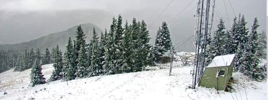
Alamo Peak South Of Cloudcroft, NM.

Valid At 6 AM MDT Monday, Oct 3, 2022.
GFS 500 MB (18,000' MSL) Heights & Wind Forecast


Monday, October 3, 2022.


Friday, September 30, 2022.
Alamo Peak South Of Cloudcroft, NM.
Fall Is In The Air.
Our overnight low temperatures have been getting much cooler over the past few weeks and no doubt about it they feel very fall-like. Here in the Pecos Valley of Southeastern New Mexico we are starting to see a few low temps in the upper 40's show up as well as across northern Lea County. Low temps in the 30's have been occurring in a few spots in the Sacramento mountains for a couple of weeks now.
A mid-level closed low (500 millibars or 18,000' mean sea level) was located over central Montana this morning with a shortwave trough of low pressure extending southward from it into Arizona. As this low moves eastward this week a portion of this trough of low pressure will break off and drift southwest into the Baja Region by the end of the week forming another weak closed low.
At the surface, a cold front will work its way southward through New Mexico Wednesday and Thursday. Cooler temps will follow in its wake. This will keep our high temps slightly below normal from Wednesday into Friday.
Highs today across the southeastern plains are forecast to be near 80 to the low 80's. Highs on Tuesday will range from the upper 70's to near 80. Highs Wednesday into Friday will be in the low to mid 70's with a few upper 70's in a few spots.
Forecast high temperatures in the Ruidoso, Capitan, Mayhill, High Rolls, Sacramento/Weed, Pinon, and Timberon areas will range from the mid 60's today and Tuesday to the upper 50's to near 60 Wednesday through Friday.
Forecast high temperatures in the Cloudcroft, Sunspot and the Silver Lake areas will range from the mid to upper 50's today and Tuesday, to the upper 40's to the low 50's Wednesday through Friday.

Increasing Chances For Showers & Thunderstorms.
An active week weather-wise is shaping up for New Mexico. Our chances for seeing measurable rainfall will continue to increase today into the end of the week...and likely into next weekend.
Scattered rain showers and thunderstorms will increase in most areas Tuesday into Friday. As has been the case for this summer into now the mountains will have the best shot at seeing locally heavy rainfall. Storm totals may get as high as 1" - 3" by Friday in the Sacramento mountains. Localized higher totals are possible in a few spots.
Localized flash flooding will be a concern especially over and near the burn scar areas.
Localized flash flooding will be a concern especially over and near the burn scar areas.
Across Southeastern New Mexico scattered storm totals of .50" to 1.50" are possible Tuesday through Friday.
Remnant tropical moisture from Hurricane Orlene which has just made landfall 45 miles southeast of Mazatlan, Mexico this morning will add fuel to the fire for additional thunderstorms late this week into the weekend for the area.

Snow Possible Over The Higher Peaks Of Northern NM.
A couple inches of fresh snowfall is forecast for the northern mountains of New Mexico today into Thursday. Which is really pretty typical for this time of the year.

A couple inches of snow has fallen along the Highline Ridge @ 12,000 ft elevation at Taos Ski Valley in the Carson NF w/ snow expected to continue near timberline at times overnight. #nmwx
There Are None So Blind As Those Who "Will - Not" To See...107.


Comments
Post a Comment
Your comments, questions, and feedback on this post/web page are welcome.