Big Changes Late This Weekend.
Near Mayhill, NM.
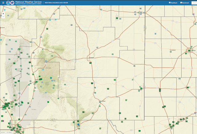
A weak and dry cold front slipped through the region yesterday drying out our airmass even further. With excellent radiational cooling overnight and clear skies locally our low temps this morning were seasonably chilly. Lows reported across the Southeastern Plains generally fell in the 45º to 50º range. Some 30's were noted in the Sacramento mountains.
Big Changes Late This Weekend.
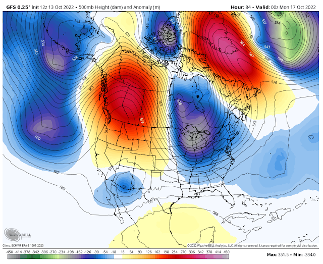
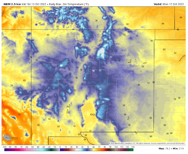
(Valid Monday, Oct 17, 2022).
(Valid At 6 PM MDT Sunday, Oct 16, 2022).
National Blend Of Models (NBM) High-Temperature Forecasts.
Friday.
Saturday.
Sunday.
Monday.
(Valid At 6 PM MDT Sunday, Oct 16, 2022).
(Valid At 6 PM MDT Tuesday, Oct 18, 2022).
(Valid At 6 PM MDT Monday, Oct 17, 2022).
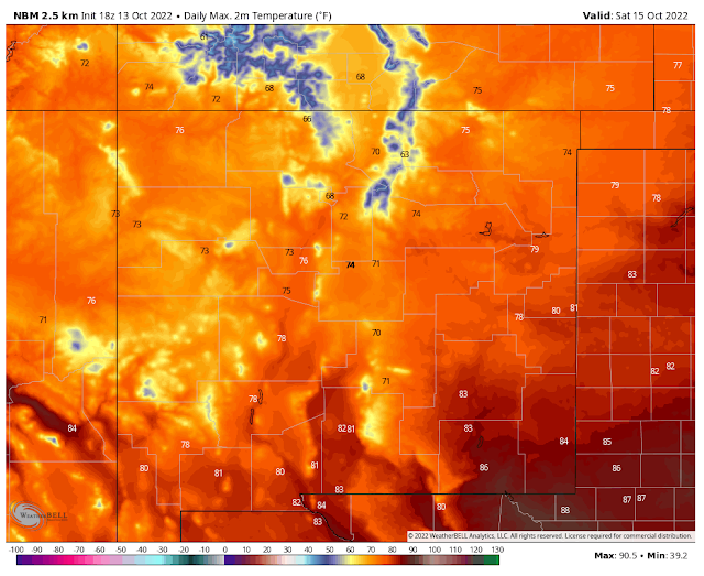
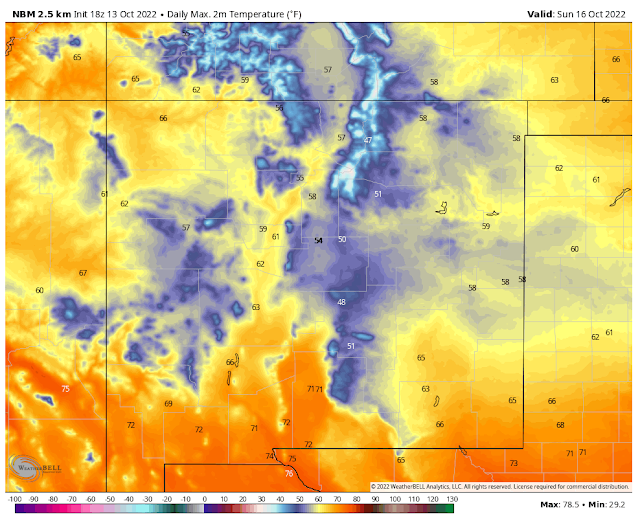
Balmy temps slightly above seasonal normal are forecast areawide Friday and Saturday. Then a strong back door cold front drops in from the north and northeast Saturday night into Sunday bringing with it a much cooler and wetter airmass. Sunday and Monday's high temps will be some 10º to 20º below normal.
A cut-off mid and upper-level low located southwest of San Diego will begin to move eastward this weekend. By Sunday night forecast models by it into southeastern Arizona. After that, the models disagree somewhat on how fast the low opens up and moves east of the area. The GFS is faster and the ECMWF is slower. If the ECMWF model is correct our period of cloudy, wet, and much cooler weather will last into Tuesday or maybe Wednesday.
Friday and Saturday will see high temps in the mid 80's across the local area except for the mountains. Where it will be in the upper 60's to near 70 in the Ruidoso area, and the upper 50's to near 60 in the Cloudcroft area.
Behind the front, Sunday into Monday, temps will hover in the 60's at the lower elevations of the Southeastern Plains. And the mid 50's on Sunday for the Ruidoso area and the mid-upper 40's on Monday. Cloudcroft will see the mid 40's on Sunday and the upper 30's on Monday. Make no doubt about it fall is in the air along with a tease of winter.
Behind the front, Sunday into Monday, temps will hover in the 60's at the lower elevations of the Southeastern Plains. And the mid 50's on Sunday for the Ruidoso area and the mid-upper 40's on Monday. Cloudcroft will see the mid 40's on Sunday and the upper 30's on Monday. Make no doubt about it fall is in the air along with a tease of winter.
Scattered rain showers and thunderstorms will increase across the local area from Saturday night into Sunday. A few strong thunderstorms will be possible along with locally heavy rainfall. By Sunday night into Monday night, we should transition over to more of a steady rain with periods of heavy rain. Light drizzle and fog will also occur behind the front Sunday into Tuesday morning.
Widespread rainfall totals from Saturday night into Monday night across the southern two-thirds of New Mexico currently are forecast to be in the 1" to 2.50" range. A few locations may see higher totals. The threat of localized flash flooding ramps up Sunday into Monday night as well.
Snow levels will drop down to around the 9,000' level late Sunday night into Monday morning. Don't be surprised if Ski Apache ends up with 1" to 3" of snow out of this storm. Cloudcroft is in the running to see snow as well but it's a coin toss right now if anything sticks on the ground. If it does current model forecasts keep any accumulation to an inch or less.
There Are None So Blind As Those Who "Will - Not" To See...107.





Comments
Post a Comment
Your comments, questions, and feedback on this post/web page are welcome.