


Another Storm Inbound.

Seven Rivers, NM.
Quick Hitting Storm Today Into Friday.

Valid At Midnight Wednesday Night.


We have had a pretty active fall weather pattern over the past few weeks and this trend will continue. Our latest storm to impact New Mexico and nearby areas was centered over northern Utah at midnight last night. This storm will dive southeastward fairly rapidly today. By sunset it is forecast to be a closed mid-upper level low centered near Albuquerque. By sunrise Friday morning it is forecast to be centered near Andrews in West Texas.

Valid At 3 AM MDT Thursday Morning.

As the mid level storm dives towards the state today a fast moving surface cold front will sweep across the state. By sunset it will have moved south into far West Texas and the northwest Permian Basin.
Today.

Friday.

Saturday.

Sunday.

Today's high temps across Southeastern New Mexico will be a little above seasonal normals with the mid 70's. Behind the cold front on Friday we will see the upper 50's to the low 60's. Saturday will be a little warmer with highs in the upper 60's and near 70 for Sunday.
In the Ruidoso area you can expect to see high temps today in the low 50's, near 50 on Friday, and the mid-upper 50's on Saturday and Sunday.
The Cloudcroft area will see the low to mid 40's today and Friday, the mid 40's on Saturday, and the upper 40's on Sunday.

Valid Today Through Friday.
Strong westerly winds sustained at around 25-35 mph with gusts near 50 are expected across Eddy County today where a Wind Advisory will be in effect from noon until 11 PM. Westerly winds sustained at around 20-30 mph with gusts near 40-45 mph are forecast for the rest of Southeastern New Mexico.
A Wind Advisory is also in effect for the southern Sacramento mountains and the Dell City, Cornudas, Salt Flats, and Crow Flats areas from 9 AM through 11 PM. West winds sustained at around 25-35 mph will gust up to around 55 mph.
A High Wind Warning is in effect for the Guadalupe mountains until 11 PM MDT for west winds sustained at around 35-45 mph with gusts near 65 mph.
Localized areas of blowing dust will be possible this afternoon and evening with the stronger winds and gusts. Particularly over and near freshly plowed farm lands, fields, open or exposed lots, and construction sites.

Valid Today Through 6 PM MDT Friday.
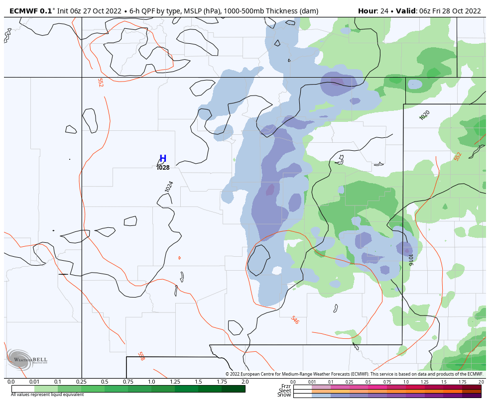
NWS NDFD Storm Total Precipitation Forecast.
 Valid Today Through 6 AM MDT Friday Morning.
Widely scattered to scattered rain showers will develop across the local area this afternoon and continue into early Friday morning before ending. For the most part local totals should be around a quarter of an inch or less. A few sots may pick up as much as a half of an inch.
ECMWF Storm Total Snowfall Forecast.

NWS NDFD SF Forecast.


Scattered rain showers are forecast to change over to snow showers across the Sacramento mountains late this afternoon and evening. The higher elevations around Sunspot and Cloudcroft may pick an inch or two of snow. Ski Apache may see 2"-3". The Ruidoso area is currently expecting (as of 8 AM MDT) to only see a half of an inch or less. This storm is going to be fairly moisture starved thus the reason for the light accumulations. However it's possible that the highest elevations of the Sac's may end up getting more snow than currently forecast.
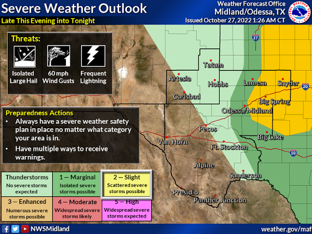
Severe T-Storm Across West Texas Tonight..


Late this afternoon into this evening scattered thunderstorms are forecast to develop across West Texas. Some of these may become severe and produce large hail, damaging thunderstorm wind gusts, and locally heavy rainfall. Current forecasts indicate that most of this activity will develop along or east of a Lubbock to Midland line around sunset or afterwards.
There Are None So Blind As Those Who "Will - Not" To See...107.


Comments
Post a Comment
Your comments, questions, and feedback on this post/web page are welcome.