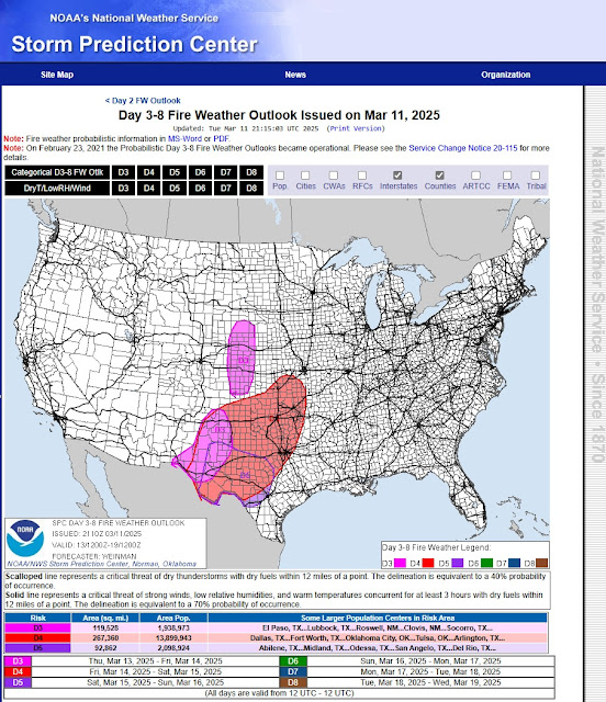
Widespread Significant Damaging Wind - Blowing Dust - Extreme Fire Danger Event Thursday Into Friday.
Dust Suspended In The Air.
Halfway Between Carlsbad & Hobbs, NM.
Very Stable Conditons With Calm Winds Cause This.
"A potentially historical, multi-hazard spring storm system will impact the region Thursday through Saturday."
This is the opening statement from the Albuquerque National Weather Service Office Area Forecast Discussion this morning. It is rare to see this type of wording from our local NWS offices.
Widespread Blowing Dust.
Damaging Winds & Brownout Conditions Friday!
National Blend Of Models (NBM) Peak Wind Gust Swath Forecast.
Once again, multiple High Wind Warnings, High Wind Watches, Wind Advisories, Red Flag Warnings, Fire Weather Watches, Winter Storm Warnings, and Winter Storm Watches have already been issued for the state and nearby areas. Additional warnings, advisories, and changes to some of our forecasts will likely be issued today through Friday.
So, please click on this link to view the latest updates. Or, visit my weather web page often for all of the latest updates. Or your favorite media outlet.
High Winds & Blowing Dust Today.
Damaging Winds & Widespread Blowing Dust Thursday Night Into Friday!
Today will be windy across western, southern, southeastern, and eastern areas of the state, where High Wind Warnings and Wind Advisories are in effect. West winds in the High Wind Warning areas will become sustained at 35 to 45 mph with gusts to 60 mph today for Eddy County and the Guadalupe mountains. Locally higher gusts are possible in a few areas.
Wind Advisories are in effect for Lea County, parts of southern New Mexico, and much of West Texas for west winds becoming sustained at 25 to 35 mph, gusting up to 50 mph.
High Wind Watches are in effect from Thursday night into Friday for much of southern, south-central, and the central mountain chain eastward out onto the eastern plains, including southeastern New Mexico. West winds are forecast to become sustained at 35 to 50 mph with gusts to 70 to 75 mph! Some locations may experience gusts over 80 mph!
West winds will likely become sustained at 50 to 60 mph with gusts over 80 mph on Thursday night in the Pine Springs and Guadalupe Pass areas (including Guadalupe Pass). On Friday, these winds are forecast to increase to sustained speeds of 60 to 65 mph with gusts near 95 mph! It is not out of the question that these gusts may approach 110 mph on Friday!
Damaging winds are likely Thursday night into Friday for many areas of the state. Power poles, power lines, and utility lines may be blown down. Trees and fences, along with outbuildings and barns, may be damaged or blown down. Farmland irrigation systems may be damaged or blown away, especially if they are not staked down and have water running in them. Some west-facing windows may be blown out.
Widespread Blowing Dust Thursday Into Friday!
Brownouts Possible Friday!
Areas of blowing dust will develop later this morning and after across parts of southern, south-central, and southeastern New Mexico. Localized drops in the visibility due to blinding dust storms with little to no advanced warning will occur, especially in and near our more dust-prone areas.
Widespread blowing dust will likely develop over southern New Mexico Thursday night and spread eastward and northeastward into south-central, southeastern, and eastern New Mexico and nearby West Texas. A strong Pacific cold front is forecast to race rapidly from west to east across the state Thursday night, and by sunrise Friday morning, this front is forecast to be located from the Texas Big Bend northeast to the DFW area.
Widespread brownout conditions due to widespread blowing dust born upon 70 to 80 mph westerly wind gusts on Friday will make travel over much of the area extremely dangerous and even life-threatening! Widespread areas of near zero to zero visibilities will occur and may last for hours in some cases. Road closures are a strong possibility in these conditions.
Not only southeastern New Mexico but other nearby areas have a long history of multiple vehicle pileups in these blinding dust storms. Many times with injuries and, sadly, sometimes fatalities. Unless you absolutely must drive in the local area on Frida,y please consider not doing so unless it's an emergency.
Critically Dangerous Fire Weather Conditions will exist across the local area today and Thursday. Red Flag Warnings are already flying, and these will continue and increase in number, especially on Friday.
Extremely Critically Dangerous Fire Weather Conditions will occur on Friday! Large, rapidly moving, and life-threatening wildfires will be possible during this extreme high-wind event. Especially if power poles and power lines are blown down.
Please refrain from any outdoor activity that involves the use of sparks or flame. Do not toss cirgrattes out of your vehicle or pull over onto the side of the road in tall grass. The hot exhaust pipes and catalytic converters on your vehicles may start a fire. Do not let chains drag on the payment behind your vehicle either, as they may cause sparks that can cause a fire. Similar weather conditions were in place that produced the 92,000 McDondald rangeland fire on March 12, 2006.
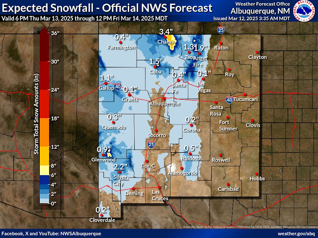
Near Blizzard Conditions Western & Northern Moutnains!
High winds and moderate to heavy snowfall over parts of the western and northern mountains may produce near blizzard to blizzard conditions on Friday. With another round of light snow and blowing snow on Saturday.
Rain and snow showers are forecast for the Sacramento mountains Thursday night and again Saturday. An inch or two is possible over the higher elevations of the Sac's, along with blowing snow.
A few scattered light to moderate rain showers are forecast for the lower elevations of the western one-half of the state Thursday into Friday night. With the heaviest totals occurring over and near the mountains.
Area Forecast Discussion
National Weather Service Midland/Odessa TX
401 AM CDT Wed Mar 12 2025

...New AVIATION...

.KEY MESSAGES...
Updated at 400 AM CDT Wed Mar 12 2025

- High Wind hazards and a Red Flag Warning are in effect areawide
  today as a storm system brings winds and heightened fire
  weather concerns. Critical fire weather conditions and reduced
  visibility due to blowing dust remain the main impacts through
  this evening.

- A more potent system is set to arrive Friday, once again
  bringing strong to very strong winds and critical to extreme
  fire weather concerns to the area. Temperatures take a slight
  dip behind the cold front.

- A warming trend begins heading into next week before another
  system makes its way in around Tuesday/Wednesday.
Area Forecast Discussion...UPDATED
National Weather Service Albuquerque NM
518 AM MDT Wed Mar 12 2025

...New AVIATION...

.KEY MESSAGES...
Updated at 506 AM MDT Wed Mar 12 2025

- Winds trend stronger today as a fast-moving Pacific storm moves
  through. Light rain/snow will favor western areas while winds
  and fire weather concerns return to east central NM.

- A potentially historical, multi-hazard spring storm system will
  impact the region Thursday through Saturday. The main hazards
  will be widespread strong to damaging wind gusts, increased fire
  danger and blowing dust in the east, and snow that will favor
  the western and northern mountains where strong winds will
  create blizzard-like conditions.

- There is moderate confidence that the active weather pattern
  will continue after the weekend, with more chances for
  precipitation, strong winds, critical fire weather and blowing
  dust early next week.

&&

.SYNOPSIS...
Issued at 311 AM MDT Wed Mar 12 2025

A very active weather pattern will continue through the rest of the
week. Breezy to windy conditions occur today across the southeast
parts of the state, with critical fire conditions accompanying the
winds. A very powerful spring storm begins to impact the region
Thursday evening and continue through Saturday. Strong to damaging
wind gusts with blowing dust are likely across much of central and
eastern New Mexico, especially Friday afternoon. The storm will also
bring snow to the northern and western mountains, and the high wind
gusts may create blizzard like conditions with blowing snow. Another
round of light snow and blowing snow is likely to occur on Saturday.
Conditions improve Sunday and Monday before another potentially
significant spring storm system brings more strong winds and
associated hazards on Tuesday.

&&
Area Forecast Discussion National Weather Service El Paso TX/Santa Teresa NM 520 AM MDT Wed Mar 12 2025 ...New AVIATION... .KEY MESSAGES... Updated at 452 AM MDT Wed Mar 12 2025 - Series of Pacific storms will bring strong winds and a chance of showers to the area on Tuesday and Thursday/Friday. - Blowing dust/poor visibility will once again be the biggest impact on both Tuesday and Thursday afternoon. - Fire weather will be a concern for much of the area through Friday. - Mountain snow and lowland rainfall on Wednesday and again on Friday. - High Wind Watch will go in effect on Thursday night into Friday morning for Sacramento, Black/Gila, and Franklin mountains.URGENT - WEATHER MESSAGE National Weather Service El Paso Tx/Santa Teresa NM 1230 PM MDT Wed Mar 12 2025 NMZ415-416-427-429-TXZ419-130500- /O.UPG.KEPZ.HW.A.0003.250314T0000Z-250314T1800Z/ /O.NEW.KEPZ.HW.W.0003.250314T0000Z-250314T1800Z/ /O.NEW.KEPZ.DU.Y.0011.250313T2100Z-250314T0300Z/ Sacramento Mountains Above 7500 Feet-East Slopes Sacramento Mountains Below 7500 Feet-West Central Tularosa Basin/White Sands- Southeast Tularosa Basin-Eastern/Central El Paso County- Including the cities of Sacramento, White Sands National Park, Cloudcroft, East and Northeast El Paso, Apache Summit, Mayhill, Sunspot, Chaparral, White Sands Range Headquarters, Socorro, Pinon, Fort Bliss, and Orogrande 1230 PM MDT Wed Mar 12 2025 ...BLOWING DUST ADVISORY IN EFFECT FROM 3 PM TO 9 PM MDT THURSDAY... ...HIGH WIND WARNING IN EFFECT FROM 6 PM THURSDAY TO NOON MDT FRIDAY... * WHAT...For the Blowing Dust Advisory, visibility between one-quarter and one mile in blowing dust expected. For the High Wind Warning, west winds 35 to 45 mph with gusts up to 75 mph expected. * WHERE...In New Mexico, East Slopes Sacramento Mountains Below 7500 Feet, Sacramento Mountains Above 7500 Feet, Southeast Tularosa Basin, and West Central Tularosa Basin/White Sands. In Texas, Eastern/Central El Paso County. * WHEN...For the Blowing Dust Advisory, from 3 PM to 9 PM MDT Thursday. For the High Wind Warning, from 6 PM Thursday to noon MDT Friday. * IMPACTS...Hazardous driving conditions due to reduced visibility. Strong gusty winds could cause structural damage and will blow around unsecured objects. Tree limbs could be blown down and a few power outages may result. PRECAUTIONARY/PREPAREDNESS ACTIONS... Persons with respiratory problems should make preparations to stay indoors until the storm passes. Be ready for a sudden drop in visibility to near zero. If you encounter blowing dust or blowing sand on the roadway or see it approaching, pull off the road as far as possible and put your vehicle in park. Turn the lights all the way off and keep foot off the brake pedal. Remember, `Pull Aside, Stay Alive`. Remain in the lower levels of your home during the windstorm, and avoid windows. Watch for falling debris and tree limbs. Use caution if you must drive. && $$
There Are None So Blind As Those Who "Will - Not" To See...107.


Comments
Post a Comment
Your comments, questions, and feedback on this post/web page are welcome.