T-Storms Return But With Mixed Results.
Sacramento Mountains East Of Alamogordo, NM.
Cumulus/Altocumulus Standing Lenticular/Cirrostratus Clouds.
T-Storms Return But With Mixed Results.
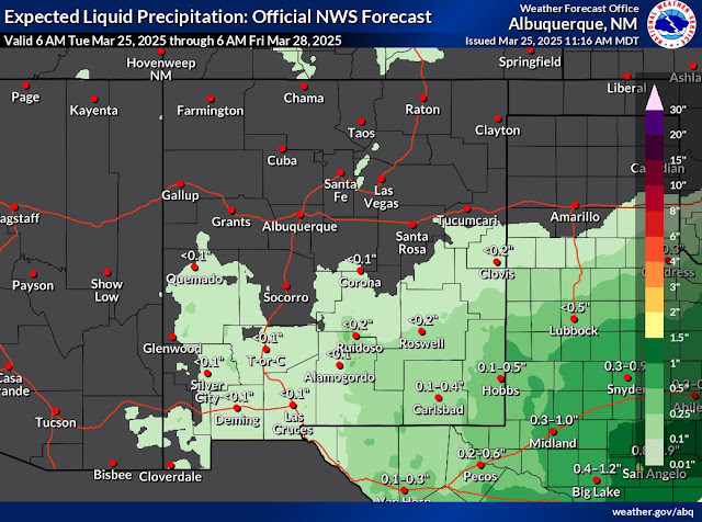
Overall not much has changed in my thinking concerning our two-day bout with widely scattered to scattered thunderstorms. Unfortunately for most of the state, these storms may end up creating more problems than good.
Dry thunderstorms are forecast for many areas of the state today into Thursday night as a mid-upper level trough of low-pressure swings eastward over the region. Low and mid-level moisture will be limited but enough will be present in combination with lift from the trough to kick off widely scattered thunderstorms.
The southeastern plains have the best chances of seeing measurable rainfall but overall forecast models call for a tenth to perhaps a half of an inch of rain mainly over Eddy and Lea Counties. The further east and southeast you go into West Texas, the better the chances for heavier rainfall become tonight and Thursday night.
A few thunderstorms may become marginally severe and produce locally moderate to heavy rainfall, frequent cloud-to-ground lightning strikes, damaging wind gusts, and hail Thursday across parts of eastern and southeastern New Mexico and West Texas.
The news is not good for the rest of the state that manages to get a thunderstorm. These storms will produce very little rainfall or virga along with cloud-to-ground lightning strikes, erratic strong downburst wind gusts, and localized areas of blowing dust. Given the ongoing extremely dry conditions the fire danger is high.
A Fire Weather Watch is in effect for the 4-Corners area and northeastern New Mexico on Friday. Strong winds, localized areas of blowing dust, and critically dangerous fire weather conditions are on tap for the state Friday and Saturday and again early next week. The northern mountains may see more snow the middle to end of next week. Long-range outlooks over the next two weeks are repeating what we already know...above normal temps and drier than normal conditions.
Area Forecast Discussion
National Weather Service Midland/Odessa TX
631 AM CDT Wed Mar 26 2025

...New AVIATION...

.KEY MESSAGES...
Updated at 629 AM CDT Wed Mar 26 2025

- Rain chances increase this afternoon and continue through
  Thursday night. A few storms could be strong to severe,
  producing gusty/damaging winds and hail, mainly south and east
  of an Alpine to Garden City line.

- There is medium to high (50-70%) confidence for many locations
  receiving at least a tenth to a quarter of an inch of rain
  during this period. Higher rainfall amounts will be possible
  with stronger storms.

- Dry weather and well above normal temperatures return by the
  weekend.

&&
Area Forecast Discussion...UPDATED
National Weather Service Albuquerque NM
552 AM MDT Wed Mar 26 2025

...New AVIATION...

.KEY MESSAGES...
Updated at 543 AM MDT Wed Mar 26 2025

- Isolated and gusty virga showers and dry thunderstorms today and
  Thursday, except for increased chances of wetting thunderstorms
  over south central, east central and southeast areas Thursday
  afternoon.

- Blowing dust may drop below a half mile for up to an hour with
  gusty thunderstorms in dust-prone parts of the central valley
  and eastern plains during the afternoon and early evening today
  and Thursday.

- Southwest and west winds will strengthen Friday and especially
  Saturday, then again Monday and especially Tuesday, with areas
  of critical fire weather conditions forecast each day.

&&

.SYNOPSIS...
Issued at 310 AM MDT Wed Mar 26 2025

Isolated showers and thunderstorms will produce more in the way of
wind than rain over northern, central, and eastern areas this
afternoon and evening. Mostly dry thunderstorms are again forecast
along and east of the continental divide on Thursday, except for
an increased chance of wetting cells over south central, east
central and southeast areas. West and southwest winds will
strengthen Friday and especially Saturday, then again Monday and
especially Tuesday, with areas of critical fire weather conditions
forecast each day.

&&
Area Forecast Discussion
National Weather Service El Paso TX/Santa Teresa NM
529 AM MDT Wed Mar 26 2025

...New AVIATION...

.KEY MESSAGES...
Updated at 524 AM MDT Wed Mar 26 2025

 - Chance of showers/thunderstorms today and Thursday.

 - Above average temperatures will persist through the week and
   into the weekend.

 - Windy and near-critical fire conditions return to the forecast
   on Friday and Saturday.

&&
Today.
Thursday.
Today & Thursday.
There Are None So Blind As Those Who "Will - Not" To See...107.


Comments
Post a Comment
Your comments, questions, and feedback on this post/web page are welcome.