Impressive Rainfall Totals For Sept 28-29, 2012.
Blog updated at 7:20 PM MDT.
(Additional Rainfall Reports Added).
(Additional Rainfall Reports Added).
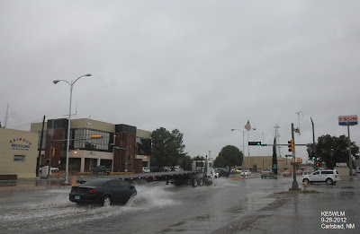
Street flooding in Carlsbad yesterday afternoon.
(As Of 7 AM MDT).
Lea County 48-Hour Totals.
Lincoln County 24-Hour Totals.
Otero County 24-Hour Totals.
Otero County 48-Hour Totals.
Midland County Texas 24-Hour Rainfall Totals.
Midland County Texas 48-Hour Rainfall Totals.
Ector County Texas 48-Hour Rainfall Totals.
GRLevel3 2.00 Estimated Rainfall Totals.
Midland NWS Doppler Radar.
Cannon AFB Doppler Radar.
Lubbock NWS Doppler Radar.
El Paso/Santa Teresa NWS Doppler Radar.
Holloman AFB Doppler Radar.
Widespread heavy rains fell over southeastern New Mexico and parts of west Texas Thursday and Friday. Locally the Carlsbad Airport measured a two day total of 2.43". The Dark Canyon Draw automated gauge recorded a two day total of 2.91". The Queen Raws located 3 miles east of Queen recorded a two day total of 2.31". The Bat Draw Raws located at the Carlsbad Caverns Visitor Center recorded a two day total of 2.25".
The Hobbs Airport recorded a two day total of 3.15". The Hagerman automated gauge located 10 miles east-southeast of Hagerman recorded a two day total of 2.14". I recorded a two day total here at my home in northwest Carlsbad of 1.63". A two day total of 1.71" was reported 5 miles southeast of Carlsbad by the Eddy County Emergency Manager. The McKittrick Canyon Raws located in the Guadalupe Mountains National Park near Pine Springs is reporting a two day total of 1.74".
Additional two day rainfall totals include- The Hobbs Mesonet Raws 3.14", the Carlsbad Caverns Climate Co-Op Station 2.28", the Fort Stockton Airport 2.17", the Jal Climate Co-Op Station with 2.16", the Tatum Mesonet Raws 1.13", the Caprock Raws .71".
Local public reports include- 1 mile north of Lakewood 1.75", McNew Subdivision 5 miles north of Carlsbad 1.70", Brantley Lake State Park 1.50", South Artesia (13th & Tumbleweed) 1.50", South Carlsbad (Wood & Najar) 1.30", South Carlsbad Sierra Rd 1.20", Cottonwood north of Artesia 1.10", 2 miles east of Hagerman near 1.00".
A record rainfall of 4.66" was set at Midland for September 28, 2012. This breaks the old record of 2.06" set in 1980. This also breaks the daily record for the month of September...the previous record was 3.60" on September 5, 1944. This 4.66" is the third wettest day on record in Midland. The record days are (1) 5.32" on August 24, 1934, and (2) 4.75" on May 9, 1968.
The Davis Vantage Pro2 Weather Station located at the Midland Emergency Management Office is reporting a storm summary of 6.42" of rain as of 9:30 AM CDT.
Additional two day rainfall totals across west Texas include- The Snyder Airport is reporting a two day total of 2.98", the Andrews County Airport is reporting a two day total of 2.11", the Big Spring Airport is reporting a two day total of 4.56", the Midland International Airport ASOS is reporting a two day total of 4.72", the Odessa-Schlemeyer Airport is reporting a two day total of 5.13", the CRN Site near Monahans is reporting a two day total of 5.22", the Midland Raws located at the Midland International Airport is reporting a two day total of 5.83", the Beals Creek Near Westbrook automated gauge located east of Big Springs is reporting a two day total of 8.33".
Additional rainfall totals will be added later today, and I will also update any of the totals posted above if needed. Remnant moisture from former Hurricane Miriam and remnant moisture from Tropical Storm Norman (son of Miriam) combined to produce the widespread heavy rains across the area. Its been a long time in coming.
The Truth Is Stranger Than Fiction!
My Web Page Is Best Viewed With Google Chrome.


Comments
Post a Comment
Your comments, questions, and feedback on this post/web page are welcome.