Posts

Showing posts from November, 2018

Current Date & Time

Snow For The Sac's - High Winds & Blowing Dust For The Rest Of Us!
Image
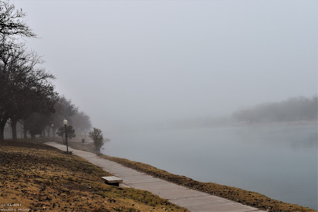
11-22-2018. Carlsbad, NM Thanksgiving Morning. Fast Moving Storm Means High Winds - Blowing Dust Today. GFS 500 MB (18,000' MSL). Valid At 11 PM MST Thursday Night. GFS 500 MB (18,000' MSL) Forecast. Valid At 5 PM MST Friday Evening. Taking a look at the upper air charts we find that a digging negatively tilted mid-upper level trough of low pressure was approaching Western New Mexico as of 3 AM MST this Friday morning. This fast moving winter storm will be centered in Northeastern New Mexico by sunset this afternoon.  Surface Map Analysis. Valid At 11 PM MST Thursday Evening. Surface Map Forecast. Valid At 5 AM MST Friday Morning. Valid At 11 AM MST Friday Morning. Valid At 5 PM MST Friday Evening.  A fast moving Pacific cold front was located in central Arizona around midnight. This cold front will blast eastward today and by sunrise it will be located in Southeastern New Mexico. By sunset it is forecast to...

Our Decent Weather Break Is Over - Winter To Return.

Image
11-22-2018. Thanksgiving Morning In Carlsbad, NM. Winter Makes A Return To NM This Weekend. GFS 500 MB (18,000' MSL) Forecast. Valid At 5 PM MST Friday. Valid At 11 AM MST Sunday. Special Weather Statement. (New Mexico Impacts Friday - Sunday). Two upper level storms are forecast to impact New Mexico and nearby areas beginning tomorrow night. Both of which are expected to dump varying amounts of snow to parts of the state. The first storm arrives in the form of a negatively tilted short wave trough of low pressure moving across New Mexico Thursday night into Friday night. The second short wave appears to be a little stronger and colder than Friday's storm and it will have the potential to dump larger snowfall totals over the mountains and parts of northern and central New Mexico on Sunday. A widespread significant winter storm is possible Saturday night into Sunday for northern and central New Mexico.  Precipitation Type Forecasts. ...

Overcast & Cold Today. Warming Up For Thanksgiving.

Image
RTMA Temperatures. (At 10:30 AM MST Sunday).   RTMA Wind Chill Temperatures. (At 10:30 AM MST Sunday). Regional Temperatures. (At 11 AM MST Sunday). Cold air has dammed up against the east slopes of the Capitan, Sacramento, and Guadalupe Mountains as of 11 AM MST this morning. It was warmer in the mountains (40's) than it was across the Southeastern Plains where most of us were still in the 30's. This just means that the colder air mass entrenched over us is rather shallow and unable to penetrate much further west than the east slopes. Note too the 50's in the Tularosa Basin and in the Las Cruces and El Paso areas. What's really wild is when shallow very cold arctic air masses are banked up against the east slopes of the mountains (December, January, February) with temps across the Southeastern Plains in the teens while the mountains are in the 50's and locations west of the mountains are in the 70's.  On rare occasions...

Turning Colder Tonight Into Sunday. Beautiful Weather For Thanksgiving.

Image
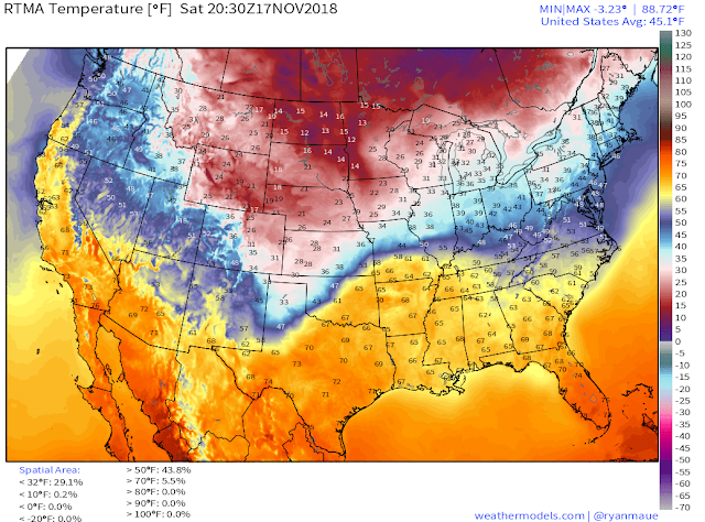
RTMA Temps & 24-Hour Change. (At 1:30 PM MST Saturday Afternoon). RTMA Temps & Wind Chills. (At 1:30 PM MST Saturday Afternoon). Regional Temps. (At 2 PM MST Saturday Afternoon). Regional Wind Chill Temps. (At 2 PM MST Saturday Afternoon).   Surface Map Analysis. (At 11 AM MST Saturday Afternoon). What a beautiful Saturday afternoon unless of course you are in not in Southeastern New Mexico where it is a pleasant 61º at 2:25 PM. A strong cold front has oozed into the local area as of 2 PM with the coldest air back to our north and northeast lagging behind the frontal boundary. Amarillo was reporting 30º with a wind chill of 17º . Clovis was reporting 37º with a wind chill of 28º . El Paso was reporting 70º . One year ago today Roswell set a new daily record high temperature for November 17th with a reading of 89º . On November 6th, 1894 they set their all-time record high for November with a reading of 9...

My Blog Archive List (July 2010 - August 2025).

Show more

My Current Weather Conditions

Eddy County

Guadalupe Mtns Eddy & Culberson County

Lea County

NWS Midland Web Page

NWS Midland Web Page
Click On The Map To Open It Up

SE New Mexico & West Texas Precipitation Forecasts

NWS Midland Forecast Graphic

NWS Midland Forecast High Temperatures Today

NWS Midland Forecast Graphic

NWS Midland Forecast Low Temperatures Tonight

New Mexico

Chaves County Plains & Mtn's

Lincoln County

NWS Albuquerque Web Page

NWS Albuquerque Web Page
Click On The Map To Open It Up

NWS Albuquerque New Mexico Precipitation Forecasts

NWS Albuquerque Forecast Graphics

NWS Albuquerque Forecast High Temperatures Today

NWS Albuquerque Forecast Low Temperatures Tonight

Otero County

NWS El Paso Web Page

Southern New Mexico & Far West Texas Precipitation Forecasts

NWS El Paso Forecast Graphics

NWS El Paso Forecast High Temperatures Today

NWS El Paso Forecast Low Temperatures Tonight

Texas

NWS Lubbock Web Page

NWS Lubbock Web Page
Click On The Map To Open It Up

NWS Lubbock South Plains Precipitation Forecasts

NWS Lubbock Graphic Forecast

NWS Lubbock Graphic Forecast

NWS Lubbock Graphic Forecast

NWS Lubbock Graphic Forecast

NWS Lubbock Hi Temperature Forecast Today

NWS Lubbock Low Temperature Forecast Tomight

Colorado

Arizona

My Precipitation Totals - 2.1 NNW Downtown Carlsbad

My Precipitation Totals - 2.1 NNW Downtown Carlsbad

My Seasonal Snowfall Totals - 2.1 NNW Downtown Carlsbad

My Seasonal Snowfall Totals - 2.1 NNW Downtown Carlsbad

Pageviews Since June 2010.

USA Weather Finder

Disclaimer

This blog and its contents are for informational purposes only! Always have multiple sources of information available to rely upon during severe weather. Do not rely solely on the Internet. Be weather-aware, plan ahead, have a backup plan, and be ready to act before severe weather strikes your location.