Posts

Showing posts from October, 2019

Record Cold Halloween!

Image
Surface Map Forecast. Valid At 6 AM MDT Wednesday Oct 30th, 2019. NAM 12 KM Precipitation Type Forecast. Valid At 6 AM MDT Wednesday Oct 30th, 2019. NWS Storm Total Snowfall Forecast.  Valid Today Through 6 PM MDT Wednesday, Oct 30th, 2019. GFS 500 MB (18,000') Forecast. Valid At 6 PM MDT Today. Record Cold Halloween. Early this Tuesday morning a powerful mid-upper level storm was developing over the Great Basin. By tonight a closed low will be approaching the Four Corners Region. As this anomalously deep ( see the NWS AFD issued at 3:32 AM MDT this morning ) closed low swings across northern New Mexico and southern Colorado Wednesday into Halloween it will send a record cold airmass southward into the area. Areas of fog, light drizzle, light rain may change over to light freezing drizzle and light freezing rain with pockets of light snow over our far northern areas later tonight into Wednesday morning.  NWS Forecast High Tempera...

First Freeze/Hard Freeze Of The Season Friday Morning.

Image
RTMA Temperatures At 7 AM MDT Friday, Oct 25th, 2019. At 7 AM MDT Friday, Oct 25th, 2019. New Mexico MesoWest Reported Low Temperatures. (As Of Midnight Friday, Oct 25th, 2019). Although many areas of New Mexico had already experienced their first freeze of the season prior to Friday morning, most of Southeastern New Mexico and nearby areas of West Texas had not. Not only did we get our first freeze but many locations had a hard freeze. Several Personal Weather Stations (PWS) in the Artesia and Roswell areas recorded unofficial low temperatures in the low 20's. Some of the colder official low temperatures recorded include: Elk Climate Co-Op Station: 16 Cloudcroft Climate Co-Op Station: 21 Roswel Portable Raws On The Caprock 23 Artesia Climate Co-Op Climate Station: 25 Guadalupe Pass ASOS: 25 Low temperatures being reported this Saturday morning a running close to Friday's lows but generally a couple of degrees warmer. ...

Cold, Windy, Raw Today - Hard Freeze Tonight.

Image
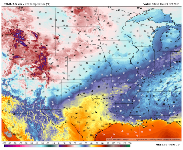
RTMA Regional Temperatures. (At 5 AM MDT This Thursday Morning). Regional MesoWest Temperatures. (At 5 AM MDT This Thursday Morning). IR Satellite Image. (At 5 AM MDT This Thursday Morning). Surface Map Analysis. (At 3 AM MDT This Thursday Morning). Surface Map Forecast. Valid At 6 PM MDT This Thursday Afternoon. Right on cue a potent cold front has swept through Southeastern New Mexico and nearby West Texas as of 5 AM this morning. Infrared satellite imagery and surface observations show low clouds (light blue shades on the image above) quickly filling in behind the cold front across the area. Temperatures locally are as warm as they are going to get today with slowly falling values throughout the day. By late this afternoon and early this evening we will be in the 30's. Wind chill temperatures are expected to drop down into the 20's and 30's today. A raw, cold, windy day is on tap...welcome to an early taste of winter...

First Winter Storm Approaching. 80's Today - 40's/50's Thursday & Friday.

Image
Oct 19th, 2019. Just Before Ski Apache West Of Ruidoso, New Mexico. Canadian (GEM) 500 MB/18,000' Forecast. Valid At 6 PM MDT Friday. Disagreement between the forecast models continues concerning the seasons first winter storm that will affect the state tonight into Friday. The GFS model continues its trend of moving the short wave trough through rather quickly instead of closing it off over the area like the European and Canadian. The European has backed off some on a closed low over Eastern New Mexico. Worst case scenario still comes via the Canadian (depicted above) which maintains a closed low over northern Southeastern New Mexico by sunset Friday. How bad this first winter storm ends up being will be highly dependent upon what happens with the track and strength of the system. Strong Cold Front Will Race Southward. Valid At 6 AM Thursday Morning. A strong fast moving cold front is forecast to overspread the area by sunrise Thursday morning. F...

Get Ready For Much Colder Weather & Maybe Some Snow By Weeks End.

Image
October 19th, 2019. Looking At Sierra Blanca Peak From The Ski Apace Gondola. Winter Weather End Of This Week? GFS 500 Millibar (18,000') Forecast. Valid At 6 AM MDT Friday, Oct 25th, 2019. ECMWF  500 Millibar (18,000') Forecast. Valid At 6 AM MDT Friday, Oct 25th, 2019. Canadian (GEM)  500 Millibar (18,000') Forecast. Valid At 6 AM MDT Friday, Oct 25th, 2019. Model confusion leads to some unknowns concerning our local forecasts for the area Thursday into Friday. Both the European and the Canadian models drop a short wave trough of low pressure into Eastern New Mexico and West Texas and close if off as a closed mid-upper level low by early Friday. Naturally the GFS disagrees and sweeps the fast moving short wave trough of low pressure across the region Thursday into Friday. So will it snow or not in parts of the local area later this week? Canadian Precipitation Type Forecast . Valid At 6 PM MDT Thursday, Oct 24th, 2019...

Current National Weather Service Watches/Warnings In Effect.

New Mexico

Chaves County Plains & Mtn's

Eddy County

Culberson County

Lea County

Lincoln County

Otero County

Current US Temps

Current US Wind Chill/Heat Index Temperatures

WPC 7-Day Precipitation Forecast

Roswell Live EarthCam

Ruidoso Live Webcam

Cloudcroft Live Webcam

NWS Midland 3-Day Precipitation Forecast

NWS Midland 3-Precipitation Chances

New Mexico 3-Day Precipitation Forecast

New Mexico Precipitation Chances

NWS El Paso 3-Day Precipitation Forecast

NWS El Paso Precipitation Chances

New Mexico 3-Day Snowfall Forecast

New Mexico Snowfall Chances

NWS El Paso 3-Day Snowfall Forecast

NWS El Paso Snowfall Chances

US 24-Hour Precipitation Forecast

US 3-Day Precipitation Forecast

US 24-Hour Snowfall Forecast

US 3-Day Snowfall Forecast