Posts

Showing posts from January, 2022

Why Are My Weather Posts Missing From Facebook.

Hello everyone. I just wanted to let you know that my Facebook page was shut down without any warning by Facebook this past Saturday, June 8th. All I was told was that I had violated their community standards. I don't know what triggered that; they didn't tell me. I was told this may be permanent or for six months.
My guess is that it may be because I posted several comments and articles from my Substack page about the riots in LA, and that must have triggered/angered someone, and they complained, thus Facebook shut me down. I don't know this as fact, though. I have appealed this decision, and I'm still waiting for their reply. I have read on X that this has happened to other Facebook users posting about the LA riots as well.
I always share my weather blog posts (that I post here) on my Facebook page and my X page. This included over twelve different New Mexico and West Texas Facebook Community sites. So there are thousands of you out there (based on my views and shares of those posts) who will no longer see those posts. My Facebook page may or may not be restored.
This is another good reason (as the National Weather Service often reminds us) to have multiple ways of receiving severe weather alerts when severe weather threatens your location. My weather web page is one of those ways, and I really appreciate all of you who have and still do use it. Thank you so much!!!
If my Facebook page is restored, I will continue to share my weather blog posts and some of the NWS Watches and Warnings...as I have been doing for years now.

Major Long-Duration Winter Storm To Impact New Mexico & Nearby Areas!

Image
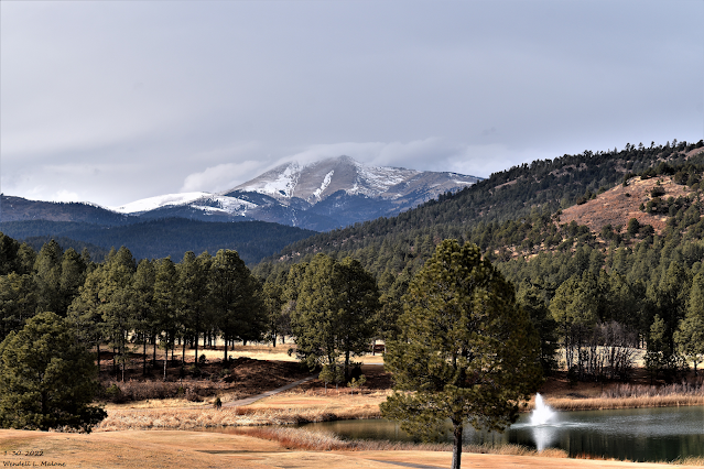
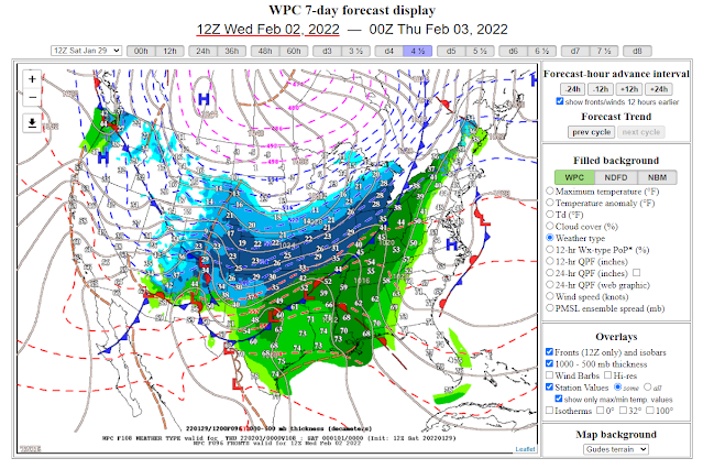
Sierra Blanca Peak. Sunday, January 30, 2022. Major Long Duration Winter Storm To Impact New Mexico & Nearby Areas! Canadian (GEM) 500 Mb (18,000') Forecast. Valid At 5 PM MST Wednesday. As has been the case for the past couple of days the computer forecast models are still struggling in trying to resolve the track, speed, and location of the 500 millibar winter storm set to impact a large swath of the region Tuesday into Saturday. Several models like the Candian above continue to hint at a closed low forming over the area Wednesday into Thursday. This would prolong the snowfall with more widespread heavier amounts. But overall there remain a lot of differences yet to be resolved which will have an impact on our local forecasts...possibly significant. So be prepared to see changes in our local forecasts. Surface Map Forecast. Valid At 5 AM MST Wednesday. A bitterly cold Siberian airmass is slated to slide into most of New Mexico beginning Tuesday across the northeastern plains ...

First Look At Next Weeks Cold & Winter Storm.

Image
Surface Map Forecast . Valid Next Wednesday. GEM 500 Millibar (18,000') Forecast. Valid At 5 PM MST Wednesday, February 2, 2022.   Computer Model Storm Total Snowfall Forecasts. (Next Wednesday Through Friday). Canadian Model (GEM). U.S. Model (GFS). European Model (ECMWF). German Model (ICON). National Blend Of Models (NBM). Canadian Model (GEM) Temperature Forecasts. (At 5 AM MST Saturday, February 5, 2022). U.S. Model (GFS) Wind Chill Forecast. (Thursday Morning At 5 AM MST). Canadian Model (GEM) 10-Day Temperature Forecasts. Albuquerque. Santa Fe. Clovis. Roswell. Carlsbad. Sierra Blanca Regional Airport. Local National Weather Service Office Outlooks. Coldest/Strongest Winter Storm This Season Next Week? Computer forecast models this morning were relatively close to one another considering their forecasts for a winter storm to impact the state and region next week. As always the models have their differences in the strength, timing, and track of the storm but all agree that wi...

Historic Major Winter Storm For Southern New England Tonight Into Saturday!

Image
A fascinating Area Forecast Discussion (AFD) from the Norton/Boston, MA National Weather Service Forecast Office this afternoon. You just don't see this very often. I want so bad to be there. Blizzard Warnings! Quote- "FXUS61 KBOX 282125 AFDBOX Area Forecast Discussion National Weather Service Boston/Norton MA 425 PM EST Fri Jan 28 2022 .SYNOPSIS... A cold front moves through the region this afternoon, possibly accompanied by a few snow showers or flurries. A historic major winter storm will impact much of southern New England Saturday into Saturday evening, bringing heavy snow, blizzard conditions to the much of southeastern New England, and possibly damaging winds and coastal flooding. Drier weather returns with below normal temperatures Sunday before a warm up next week. && .NEAR TERM /UNTIL MIDNIGHT TONIGHT/... Quiet before the storm through this evening. So be sure to take advantage to make any pre-storm preparation. There are some flurries or scattered light sn...

First Ice Storm Of The Season Late Tonight Into Wednesday.

Image
Next Round Of Winter Weather Tonight Into Wednesday. RAP 500 MB Analysis. Valid At 1 PM MST Tuesday. ECMWF 500 MB Forecast. Valid At 11 AM MST Wednesday. Looking at the 18,000' level (500 Millibars) of the atmosphere this Tuesday afternoon shows that a fairly strong and cold mid-upper level storm was centered over far northwestern Arizona as of 1 PM MST. This next inbound winter storm is forecast to continue moving southeast tonight into Wednesday morning. By around noontime tomorrow it is forecast to be located near Ruidoso. The storm is then forecast to swing east out of the state into the Texas Panhandle by sunset. Surface Map & Precipitation Type Forecast. Valid Tonight. Valid Wednesday. Current Temperatures At 3 PM MST. Current Wind Chill Temperatures At 3 PM MST. Temperatures Drop Tonight & Won't Recover Wednesday! Arctic air has entered far northeastern New Mexico as of 3 PM MST this Tuesday afternoon. Temperatures at Raton and Clayton were near freezing with win...

NWS Albuquerque Burn Scar Matrix

Current National Weather Service Watches/Warnings In Effect.

New Mexico

Chaves County Plains & Mtn's

Eddy County

Culberson County

Lea County

Lincoln County

Otero County

Current US Temps

Current US Wind Chill/Heat Index Temperatures

WPC 7-Day Precipitation Forecast

Roswell Live EarthCam

Ruidoso Live Webcam

Cloudcroft Live Webcam

NWS Midland 3-Day Precipitation Forecast

NWS Midland 3-Precipitation Chances

New Mexico 3-Day Precipitation Forecast

New Mexico Precipitation Chances

NWS El Paso 3-Day Precipitation Forecast

NWS El Paso Precipitation Chances

US 24-Hour Precipitation Forecast

US 3-Day Precipitation Forecast