Posts

Showing posts from February, 2012

Why Are My Weather Posts Missing From Facebook.

Hello everyone. I just wanted to let you know that my Facebook page was shut down without any warning by Facebook this past Saturday, June 8th. All I was told was that I had violated their community standards. I don't know what triggered that; they didn't tell me. I was told this may be permanent or for six months.
My guess is that it may be because I posted several comments and articles from my Substack page about the riots in LA, and that must have triggered/angered someone, and they complained, thus Facebook shut me down. I don't know this as fact, though. I have appealed this decision, and I'm still waiting for their reply. I have read on X that this has happened to other Facebook users posting about the LA riots as well.
I always share my weather blog posts (that I post here) on my Facebook page and my X page. This included over twelve different New Mexico and West Texas Facebook Community sites. So there are thousands of you out there (based on my views and shares of those posts) who will no longer see those posts. My Facebook page may or may not be restored.
This is another good reason (as the National Weather Service often reminds us) to have multiple ways of receiving severe weather alerts when severe weather threatens your location. My weather web page is one of those ways, and I really appreciate all of you who have and still do use it. Thank you so much!!!
If my Facebook page is restored, I will continue to share my weather blog posts and some of the NWS Watches and Warnings...as I have been doing for years now.

Video Of The Blinding Dust Storm In Artesia, NM Today.

Image
Blog updated at 7:00 AM MST Wed Feb 29, 2012. Today's NASA MODIS Visible Satellite Image Of NM. Sand Is Being Blown Northeastward From White Sands, And The Brown Splotches Are Blowing Dust Over Mexico, And Southeastern/Eastern New Mexico. 15-Vehicle Pile Up North Of Artesia Tuesday. Blowing dirt is blamed for this multi-car crash on U.S. Highway 285 north of Artesia early Tuesday afternoon, according to N.M. State Police. Officers were first called to a two-car collision at around 12:30 p.m., but a total of 15 vehicles eventually crashed into the pileup, said NMSP Sgt. Lawrence Murray. Ten people were hospitalized - eight of those transported by ambulance - but none were seriously injured, police said. Article is courtesy of the Carlsbad Current Argus. http:// www.currentargus.com/ ci_20066513 As of 2:30 PM MST this afternoon some of the stronger wind gusts that already been recorded include- WSMR - Salinas Peak (Sierra County) 107 mph WSMR - Museum 83 mph WSMR (EMRE) - NE of S...

Very Windy & Dusty Today!

Image
Blog updated at 2:35 PM MST. Today. Map Is Courtesy Of The Midland NWS Office. Map Is Courtesy Of The Midland NWS Office. Map Is Courtesy Of The Albuquerque NWS Office. Map Is Courtesy Of The El Paso NWS Office. Map Is Courtesy Of The Lubbock NWS Office. Visible Satellite Image At 1:45 PM MST Today. Strong southwesterly-westerly winds are already howling to the west of us. As of 2:30 PM MST this afternoon some of the stronger wind gusts that already been recorded include- WSMR - Salinas Peak (Sierra County) 107 mph WSMR - Museum 83 mph WSMR (EMRE) - NE of San Augustine Pass 79 mph Sierra Blanca Regional Airport 74 mph WSMR Main Post 70 mph WSMR- Bldg 1830 69 mph Artesia Airport AWOS 67 mph Pine Springs - GNP 65 mph San Augustine Pass - Organ Mtn's 63 mph Guadalupe Pass ASOS 63 mph Dunken Raws 60 mph Bowl Raws - North Of Guadalupe Pk 59 mph Tatum MesoNet 59 mph 2 SW Tatum 57 mph Carlsbad Airport ASOS 56 mph Dunken Raws 55 mph Carlsbad - NMAQ 55 mph Roswell Airport ASOS 5...

High Wind & Blowing Dust Event Tuesday!

Image
Tonight. Map Is Courtesy Of The Midland NWS Office. Areas of low clouds, fog, and drizzle are forecast to develop across SE NM and W TX tonight. Areas of dense fog will be possible which may drop the visibility down to less than 1/4 of a mile later tonight into tomorrow morning in some locations.  Tuesday. Map Is Courtesy Of The Midland NWS Office. Map Is Courtesy Of The Albuquerque NWS Office. Map Is Courtesy Of The El Paso NWS Office. Map Is Courtesy Of The Lubbock NWS Office. You are not going to like tomorrow's weather across the area. A widespread High Wind and Blowing Dust Event appears to be shaping up. High winds are forecast to kick up across the Guadalupe and Sacramento Mountains around 2 AM MST tonight. Critically Dangerous Fire Weather Conditions are also anticipated. Please see this Special Weather Briefing courtesy of the Albuquerque National Weather Service Office. A High Wind Warning is in effect for the Guadalupe M...

Cooler Today - Wind & Dust Tuesday.

Image
Today's Outlook. Surface Map Forecast For Today At 11 AM MST. Map Is Courtesy Of The Midland NWS Office. Gusty northerly winds are occurring along and behind  a cold front as it slips southward through the local area early this morning. As of 5:30 AM the Bat Draw Raws located at the Carlsbad Caverns Visitor Center had recorded a peak gust of 46 mph. The Carlsbad Airport ASOS was gusting up to 32 mph, while the Artesia Airport AWOS was clocking a gust of 29 mph. Today will be cooler behind the front and a little on the breezy side this morning. Our afternoon high temperatures are forecast to range from 54 in Hobbs, to 60 in Roswell, 63 in Artesia, and 65 in Carlsbad.  Low clouds along with areas of fog and drizzle may cover parts of southeastern New Mexico this morning, and more so tonight.  High  Winds - Widespread Blowing Dust  & Dangerous Fire Wx Conditions Tue! Surface Map Forecast At 5 PM MST Tue Feb 28, 2012. WR...

Very Windy Tuesday.

Image
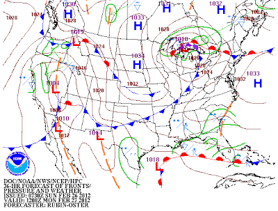
Click On The Maps To Enlarge Them. Surface Map Forecast AT 5 AM MST Mon Feb 27, 2012. WRF-NMM 500 Millibar/18,000' MSL Forecast. Valid At 5 AM MST Mon Feb 27, 2012. Map Is Courtesy Of NWS Midland. Today. Another sunny and unseasonably warm day is on tap for us today. Under sunny skies our afternoon high temperatures are forecast to range from 72 in Tatum, 73 in Hobbs, 74 in Roswell, 75 in Artesia, and 76 in Carlsbad.  Monday. A weak cold front will slip into the area late tonight or early Monday morning. Moist low-level upslope flow behind this front will help to create areas of fog across parts of SE NM and W TX later tonight, which will persists into Monday morning. The fog should burn off by late Monday morning.  Monday will be a little cooler across the area with high temperatures ranging from the low 60's to near 70. Southerly winds will increase Monday afternoon into the 15-25 mph range. Tuesday. Widespread High Wind & B...

Blowing Dust In Carlsbad/Loving, NM Today.

Image
Blog Updated At 8:40 AM Fri Feb 24, 2012. I took a drive down US Hwy 62/180 south of Carlsbad, and down US Hwy 285 from Carlsbad to Loving this morning. The visibility was reduced at times in spots, down to less than 100 feet due to the thick blowing dust. These clouds of dust were originating from the local plowed and open farmlands. The prevailing visibility was generally around 1-2 miles.  Welcome to an early arrival of spring. Yuck! Peak wind speeds reported so far to day include- Bowl Raws 1/2 Mile North of Guadalupe Peak 84 mph Guadalupe Pass ASOS 78 mph Pinery Raws In Pine Springs 75 mph McKittrick Canyon Raws 64 mph Carlsbad Airport ASOS 63 mph Queen Raws 59 mph SW Carlsbad - NMAQ  56 mph Carlsbad - Ridgecrest Subdivision 56 mph Artesia Airport AWOS 50 mph High Temperatures Reported Thursday Include- Paduca Raws 84 2.1 NNW Downtown Carlsbad 83 Artesia Airport HCN 83 Carlsbad Airport 82 Carlsbad NAMQ ...

Spring-Like Weather Today.

Image
Click On The Maps To Enlarge Them. Map Is Courtesy Of The Midland NWS Office. Surface Map Forecast At 5 PM MST. It appears that our typically warm, dry, and windy spring weather we normally see in March and April, just can't wait to get cranked up this year. Today will certainly feel like March with the high winds, areas of blowing dust, the high fire danger, and the near record warm temperatures. Our National Weather Service forecast high temperatures today will range from 74 in Tatum, to 78 in Hobbs, 81 in Roswell, 83 in Artesia, and 84 in Carlsbad. A few new records may be established.  A High Wind Warning remains in effect for the Guadalupe Mountains today through 5 PM MST. Westerly winds are forecast to be sustained at around 40-50 mph with gusts to at least 65-70 mph. Westerly winds are already howling across the Guadalupe's early this morning. As of 5:30 AM MST some of the higher gusts being noted include- The Bowl Raws 84 mph , Guadalupe Pas...

NWS Albuquerque Burn Scar Matrix

Current National Weather Service Watches/Warnings In Effect.

New Mexico

Chaves County Plains & Mtn's

Eddy County

Culberson County

Lea County

Lincoln County

Otero County

Current US Temps

Current US Wind Chill/Heat Index Temperatures

WPC 7-Day Precipitation Forecast

Roswell Live EarthCam

Ruidoso Live Webcam

Cloudcroft Live Webcam

NWS Midland 3-Day Precipitation Forecast

NWS Midland 3-Precipitation Chances

New Mexico 3-Day Precipitation Forecast

New Mexico Precipitation Chances

NWS El Paso 3-Day Precipitation Forecast

NWS El Paso Precipitation Chances

US 24-Hour Precipitation Forecast

US 3-Day Precipitation Forecast