Posts

Showing posts from July, 2021

Why Are My Weather Posts Missing From Facebook.

Hello everyone. I just wanted to let you know that my Facebook page was shut down without any warning by Facebook this past Saturday, June 8th. All I was told was that I had violated their community standards. I don't know what triggered that; they didn't tell me. I was told this may be permanent or for six months.
My guess is that it may be because I posted several comments and articles from my Substack page about the riots in LA, and that must have triggered/angered someone, and they complained, thus Facebook shut me down. I don't know this as fact, though. I have appealed this decision, and I'm still waiting for their reply. I have read on X that this has happened to other Facebook users posting about the LA riots as well.
I always share my weather blog posts (that I post here) on my Facebook page and my X page. This included over twelve different New Mexico and West Texas Facebook Community sites. So there are thousands of you out there (based on my views and shares of those posts) who will no longer see those posts. My Facebook page may or may not be restored.
This is another good reason (as the National Weather Service often reminds us) to have multiple ways of receiving severe weather alerts when severe weather threatens your location. My weather web page is one of those ways, and I really appreciate all of you who have and still do use it. Thank you so much!!!
If my Facebook page is restored, I will continue to share my weather blog posts and some of the NWS Watches and Warnings...as I have been doing for years now.

Dark Canyon Arroyo In Carlsbad, NM During Flooding - After Flooding.

Image
Normally Dry Dark Canyon Arroyo. Radio Blvd & Boyd Drive. Carlsbad, New Mexico. 6-29-2021. 7-11-2021. 6-29-2021. 6-29-2021. 7-11-2021 Normally Dry Dark Canyon Arroyo. San Jose Blvd. Carlsbad, New Mexico. 6-29-2021. 6-29-2021. 7-16-2021. 7-16-2021. Normally Dry Dark Canyon Arroyo. Looking East At The Canal St. Bridge. 6-29-2021 7-16-2021. The Truth Is Stranger Than Fiction!

Severe T-Storms - Heavy Rains - Flash Flooding Today Into Tonight.

Image
7-5-2021. Looking East From Alamogordo, NM. Severe T-Storms - Heavy Rains - Flash Flooding. Storm Prediction Center. Severe Weather Outlook Today. HRRR Rainfall Forecast. Valid At 1 AM MDT Monday Morning. A weak cold front is forecast to sag slowly southward over the local area this afternoon and evening. Favorable wind shear, instability, surface capes, and lapse rates combined with a rich moisture laded atmosphere (my dew point temp in Carlsbad at 9 AM MDT is 70ºF) will all combine to produce clusters of thunderstorms today into early Monday morning.  Thunderstorms will become severe this afternoon and evening and will be capable of producing large hail and damaging thunderstorm wind gusts in excess of 60 mph. Deadly cloud to ground lightning will accompany all thunderstorms. Locally heavy rainfall may also produce flash flooding. The area is still saturated from recent heavy to excessive rainfall so flash flooding will develop rapidly with any thunderstorm that produces heavy ra...

30-Day SE NM Rainfall Totals - June 9 -July 9, 2021.

Image
New Mexico 30-Day Precipitation Totals. (June 9 - July 9th, 2021). West Texas 30-Day Precipitation Totals. (June 9 - July 9th, 2021). Weather Underground. Personal Weather Station (PWS).  Rainfall Totals - June 23 - July 8, 2021. New Mexico CoCoRaHS. Rainfall Totals - June 23 - July 8, 2021. New Mexico CoCoRaHS. Rainfall Totals - June 23 - July 8, 2021. New Mexico MesoWest. 30-Day Precipitation Totals. June 9, 2021 - July 9, 2021. ACIS 30-Day Rainfall Totals. New Mexico New 24-Hour Rainfall Records. The Truth Is Stranger Than Fiction!

Dark Canyon Flash Flooding - Carlsbad, New Mexico. June 29, 2021.

Image
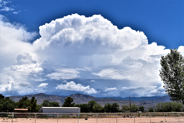
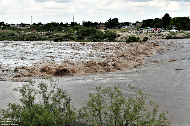
June 29, 2021. Boyd Dr & Radio Blvd. Carlsbad, New Mexico. Normally Dry Dark Canyon Arroyo. I made a typo on the time of the two videos above. It should read 4:43 PM DT and 4:45 PM MDT on the title page. Dark Canyon Flood Gauge. San Jose Blvd. My photo above was taken at 4:11 PM MDT. At 4:15 PM MDT, the floodwaters in the arroyo were measured at 17'.99". The floodwaters crested at 2:30 PM MDT with a depth at the San Jose Blvd gauge of 19'.26" at 2:30 PM MDT. This is the third-highest crest in the arroyo at that gauge since 1966. Sadly we had one flash flood fatality when a person drove their vehicle into the Dark Canyon floodwaters. June 29, 2021. Boyd Dr & Radio Blvd. Carlsbad, New Mexico. Normally Dry Dark Canyon Arroyo. June 29, 2021. Boyd Dr & Radio Blvd. Carlsbad, New Mexico. Normally Dry Dark Canyon Arroyo. June 29, 2021. San Jose Blvd. Carlsbad, New Mexico. Normally Dry Dark Canyon Arroyo. June 29, 2021. San Jose Blvd. Carlsbad, New Mexico. Normally...

NWS Albuquerque Burn Scar Matrix

Current National Weather Service Watches/Warnings In Effect.

New Mexico

Chaves County Plains & Mtn's

Eddy County

Culberson County

Lea County

Lincoln County

Otero County

Current US Temps

Current US Wind Chill/Heat Index Temperatures

WPC 7-Day Precipitation Forecast

Roswell Live EarthCam

Ruidoso Live Webcam

Cloudcroft Live Webcam

NWS Midland 3-Day Precipitation Forecast

NWS Midland 3-Precipitation Chances

New Mexico 3-Day Precipitation Forecast

New Mexico Precipitation Chances

NWS El Paso 3-Day Precipitation Forecast

NWS El Paso Precipitation Chances

US 24-Hour Precipitation Forecast

US 3-Day Precipitation Forecast