


High Winds/Blowing Dust/Critically Dangerous Fire Weather Conditions Today!
Valid At 11 PM MST Tonight.
Valid At 5 AM MST Thursday.

At 11 PM MST Tuesday.
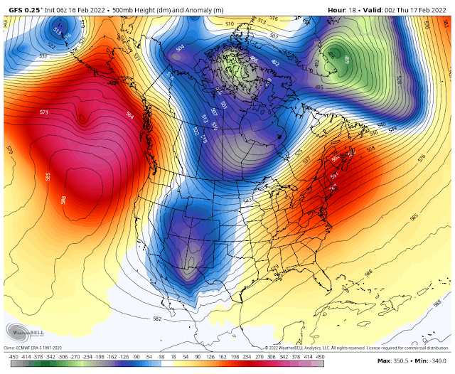
GFS 500 MB (18,000') Forecast.
Valid At 5 PM MST Today.

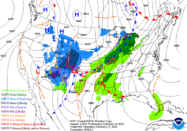
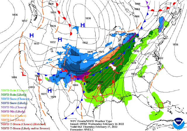
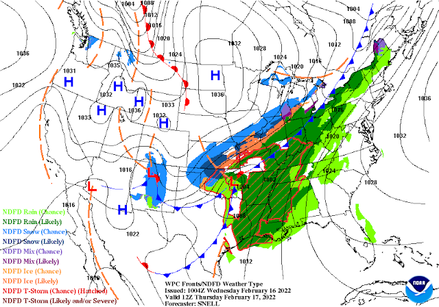
Nasty Weather Today Into This Evening.
Today is going to be one of those days most of us have learned to dread weather-wise here in southeastern and southern New Mexico as well as parts of West Texas. If you have been suffering from allergy and sinus issues lately, then today will only make you more miserable.
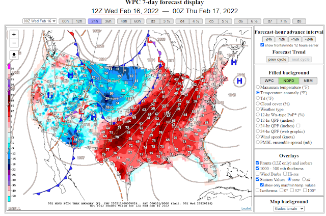
As of midnight, last night a strong closed mid-upper level low was centered near San Diego, California. This winter storm will move southeast into New Mexico today, and by sunset, it is forecast to be located just west or northwest of El Paso. It is then forecast to continue opening up into a trough of low pressure as it swings northeast into the Texas Panhandle by sunrise on Thursday. A second lobe of energy (short wave trough of low pressure) will then move southeast across New Mexico Thursday into Friday morning.
At the surface, a Pacific cold front will move from west to east across New Mexico today. By sunset, this front should be moving east out of southeastern New Mexico into West Texas. As it does so this evening it is forecast to catch up to the dryline over the Permian Basin of West Texas. Late tonight into Thursday morning a backdoor cold front will move south and west through the eastern one-half of New Mexico and across West Texas.
Low-level southeasterly upslope flow from the Gulf of Mexico has worked its way into parts of the Edwards Plateau and Trans Pecos region of West Texas this morning. Scattered thunderstorms are forecast to erupt ahead of the front and dryline this evening from the central Permian Basin eastward. Some may become severe over the eastern Permian Basin tonight and produce large hail and damaging thunderstorm wind gusts.
Low-level southeasterly upslope flow from the Gulf of Mexico has worked its way into parts of the Edwards Plateau and Trans Pecos region of West Texas this morning. Scattered thunderstorms are forecast to erupt ahead of the front and dryline this evening from the central Permian Basin eastward. Some may become severe over the eastern Permian Basin tonight and produce large hail and damaging thunderstorm wind gusts.
High Winds/Blowing Dust/Critically Dangerous Fire Weather Conditions Today!
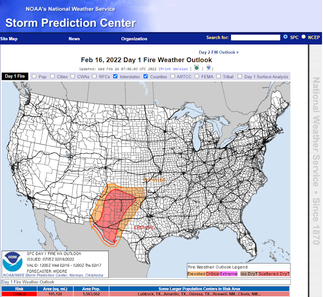
Critically Dangerous Fire Weather Conditions Today.
Another day of very high danger conditions is forecast today. Single-digit relative humidity values combined with the ongoing drought and high winds will combine to make for a potentially dangerous situation today.
Avoid any outdoor activity that involves the use of sparks or flame. Any wildland, grassland, or forest fire will have the ability to rapidly spread and grow in the high winds. Fast-moving fires could if they develop threaten life and property.
Avoid any outdoor activity that involves the use of sparks or flame. Any wildland, grassland, or forest fire will have the ability to rapidly spread and grow in the high winds. Fast-moving fires could if they develop threaten life and property.

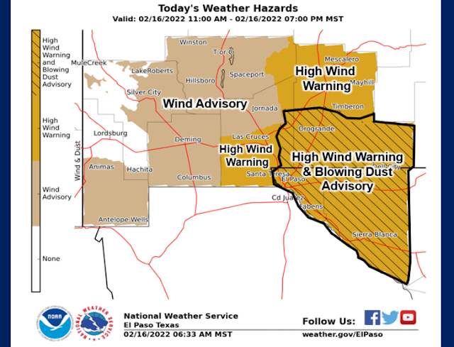
High Wind Event Today!
High Wind Warnings and Wind Advisories remain in effect today into this evening for parts of southern New Mexico, the south-central mountains, the southeastern plains, and parts of West Texas and far West Texas.
A High Wind Warning remains in effect today into 5 AM MST Thursday morning for the Guadalupe Mountains of New Mexico and West Texas. West winds are forecast to increase to 40-60 mph with gusts near 80 mph. Travel may become difficult and dangerous through Guadalupe Pass due to these high winds, blowing dust, and low visibilities. Sometimes during these high wind events, the Texas Department of Public Safety will close US Hwy 62/180 through the Pass...and this possibly could happen today.
Southwesterly to westerly winds are forecast to rake the region today into tonight.
Across southern New Mexico including the El Paso, Las Cruces, and Alamogordo areas these winds are forecast to become sustained at around 30-40 mph with gusts around 65 mph.
Across southern New Mexico including the El Paso, Las Cruces, and Alamogordo areas these winds are forecast to become sustained at around 30-40 mph with gusts around 65 mph.
Across the south-central mountains of New Mexico including the Ruidoso, Capitan, Hondo, Mescalero, Cloudcroft, Mayhill, Sacramento/Weed/Pinon, and Timberon areas these winds are forecast to become sustained at around 25-40 mph with gusts around 50-65 mph.
Across southeastern New Mexico including the Guadalupe Mountains of Eddy County as well as the rest of Eddy County these winds are forecast to become sustained at around 35-45 mph with gusts around 65 mph after 11 AM this morning.
Chaves County and Lea County as well as most of West Texas are under Wind Advisories for southwest to west winds sustained at around 25-35 mph with gusts to 45-55 mph.
There is the possibility that in some locations during the highest wind gusts (60 mph or higher) than damage could occur. This may include power lines, utility lines, trees, sheds, fences, roofs, barns, west faces windows, and agricultural sprinkler farm equipment.
Widespread Blowing Dust Today Into Tonight.

Red Hills Gas Plant - Agave Energy.
18 Miles WNW Of Jal, New Mexico.
Be aware that mid-level moisture is forecast to increase somewhat over the area this today along with the possibility of high-based rain showers or virga. A few virga bombs will be possible. It's not out of the question for an isolated dry thunderstorm to occur which will enhance this weather phenomenon should they occur and where they occur. Virga is precipitation (rain, snow, hail) that falls from the cloud bases but evaporates before it reaches the ground. This pocket of evaporating moisture then cools as it descends from the clouds. When this pocket of dry colder air slams into the ground it fans out in the form of strong gusty winds. These wind gusts have been known to reach or exceed 100 mph. During dry conditions (especially droughts like we are currently experiencing) virga bombs are common at times in the winter and spring. Thus when these pockets of very strong winds hit the ground and fan out they often stir up a lot of blowing dust...thus the nickname in the weather world of virga bombs.
A Blowing Dust Advisory remains in effect today for the Tularosa Basin, El Paso Metro, and Far West Texas including El Paso, Hudspeth, Otero, and southern Dona Ana Counties.
Widespread blowing dust will likely develop from the high plateau deserts of northern Mexico south and southwest of El Paso, northeastward across southern New Mexico, southeastern New Mexico, and parts of far West Texas and West Texas. Widespread visibility drops down to less than 3 miles is possible today into tonight in these areas in the blowing dust.
Sudden drops in the visibility down to near zero will also be possible during the highest wind gusts (60 mph or higher). This will be especially true in our normally dust-prone locations such as: Freshly plowed or cultivated farmlands, open fields, lots, and highway construction sites. Traveling upon some local highways and roads may become dangerous at times should these conditions occur. It's not out of the question that a few of these roads may become closed for awhile during these intense localized blinding dust storms.
Sudden drops in the visibility down to near zero will also be possible during the highest wind gusts (60 mph or higher). This will be especially true in our normally dust-prone locations such as: Freshly plowed or cultivated farmlands, open fields, lots, and highway construction sites. Traveling upon some local highways and roads may become dangerous at times should these conditions occur. It's not out of the question that a few of these roads may become closed for awhile during these intense localized blinding dust storms.
Snow For The Mountains Tonight Into Thursday.


This incoming winter storm is moisture-starved therefore only light snowfall amounts are currently being forecast for the Sacramento and Capitan Mountains tonight into Thursday Elevations above 6,000' may see some accumulating snowfall with 1"-3" possible in the Ruidoso and Cloudcroft areas.
The Truth Is Stranger Than Fiction!


Comments
Post a Comment
Your comments, questions, and feedback on this post/web page are welcome.