

Major Winter Storm Still On Track To Cause Us Problems!

Near Silver Lake Northeast Of Cloudcroft, NM.
Major Winter Storm Still On Track To Cause Us Problems!
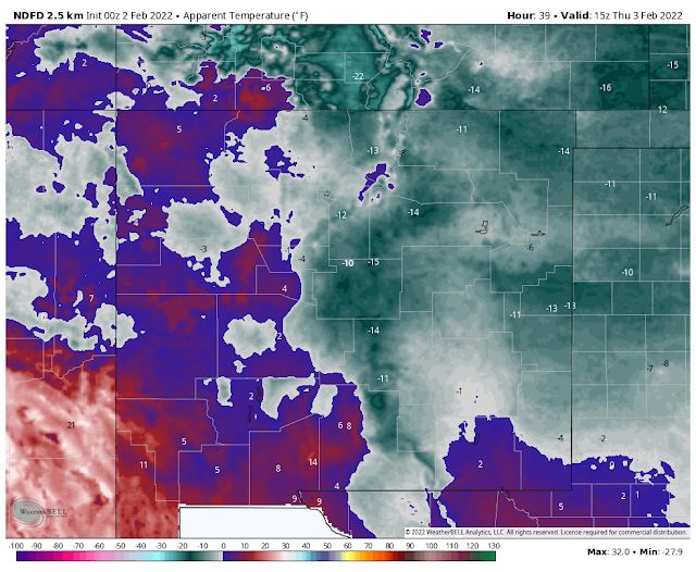
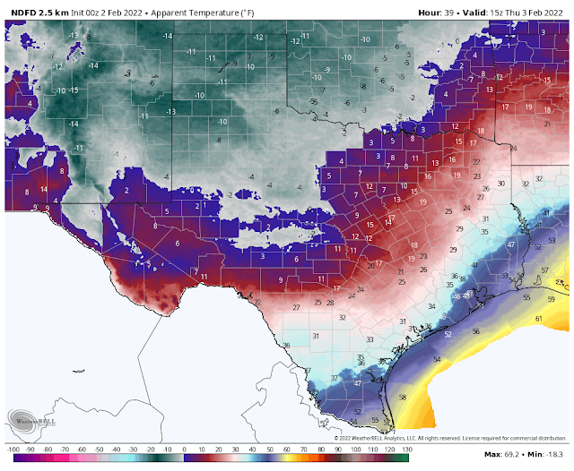
NWS NDFD Wind Chill Temperature Forecasts.
(Thursday Morning).
NWS NDFD Wind Chill Temperature Forecasts.
(Thursday Morning).
Good evening everyone. Please visit my weather web page for the very latest updates on this dangerous winter storm. . On the left-hand sidebar, you will find links to local community National Weather Service forecasts. Regional Watches, Warnings, and Advisories, as well as National Weather Service forecast graphics, are displayed on the main page as well as radar.
A Major Widespread Long-Duration Winter Storm is still on track to cause problems across New Mexico and nearby areas tonight into Saturday.
Winter Storm Warnings and Winter Weather Advisories are now in effect for much of northern, central, and the eastern 1/2 of New Mexico.
A Winter Storm Watch is in effect for Otero County and far West Texas.
A Winter Storm Warning is in effect for Chaves and Lincoln Counties.
A Winter Storm Warning is in effect for Eddy and Culberson Counties.
A Winter Weather Advisory is in effect for Lea County and much of West Texas.
A wintry mix of rain, freezing rain, and or freezing drizzle will combine with sleet and snow late tonight into Wednesday morning, and spread east and south across the state. By Wednesday afternoon and or evening most locations in the warned areas will see all snow...if not sooner.
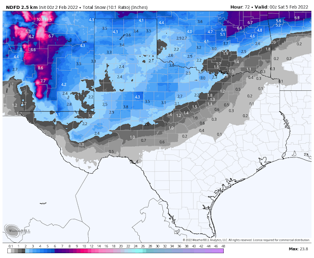
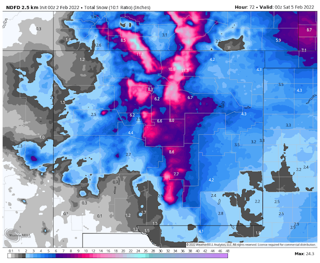
Storm total snowfall amounts over some of the states northern mountains may approach 20".
Storm total snowfall amounts across the northeastern plains are forecast to be in the 4"-6" range. The eastern plains 2"-4".
The northern Sacramento mountains including the Ruidoso area are expecting 8"-12". Ski Apache west of Ruidoso could end up with 20" or more.
The southern Sacramento mountains including the Cloudcroft and Sunspot areas are expecting to see 8"-12". Locally higher totals are possible.
The Mayhill, Mountain Park/High Rolls, Timberon, Sacramento, and Weed areas are expecting to see 6"-12".
Chaves County including the Roswell area is expecting to see 3"-4" with higher totals of near 7" in southwestern Chaves County in the Dunken area.
Far West Texas ( Crow Flats, Hueco Tanks, Cornudas, Dell City, Salt Flat, and Sierra Blanca) east of El Paso) are expecting 3"-5".
Eddy County is expecting 3"-5" with locally higher totals. Especially over the Guadalupe mountains.
Blowing and drifting snow will be possible in many areas especially Wednesday afternoon into Thursday morning.
Life-threatening wind chill values of 0ºF to -20º are still forecasted over most areas Thursday and Friday mornings.
Temperatures will plunge below freezing in some areas tonight across the northern and eastern areas of New Mexico and West Texas. The rest of the state on Wednesday. They likely will not rise above freezing until Saturday in many areas.
When the storm finally exits the state low temperatures will plunge down to near zero across the lower elevations, if not below zero in some spots. And a down to -20ºF or colder in some mountain locations, especially in northern New Mexico.
Widespread road closures are still possible in many areas Wednesday afternoon into Thursday. Travel will be impossible in some locations due to whiteout conditions, blowing and drifting snow, and visibilities near zero. If you don't have to travel...please don't. If you do you may be putting your life and others at risk. Rescue efforts may be difficult to impossible in the hardest-hit locations until after the storm ends. New Mexico has a long history of stranded motorists on its highways and roads during severe winter storms.
Power outages are possible in some areas due to strong winds, heavy snow...especially in those areas where wet snow falls and accumulates on tree branches and power lines.
Blizzard conditions are possible Wednesday afternoon into Thursday in a few areas especially in the Guadalupe and Davis mountains of southeastern New Mexico and West Texas.
Last, the computer forecast models continue to struggle with this very dynamic and complicated winter storm. Some areas may see more snow than is currently forecast and some less. So the possibility of changes in some of our local forecasts is not out of the question.
Stay weather aware and be safe!
The Truth Is Stranger Than Fiction!


Comments
Post a Comment
Your comments, questions, and feedback on this post/web page are welcome.