


Major Winter Storm Update - 10:15 AM MST, Tuesday, February 1, 2022.

Cloudcroft, New Mexico.
Regional NWS Forecast Storm Total Snowfall Amounts.
(Tuesday - Thursday).
(Tuesday - Thursday).
NWS NDFD Forecast Storm Total Snowfall Amounts.


Tuesday.


Thursday Morning.


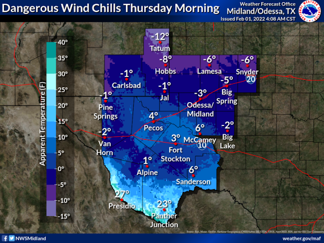
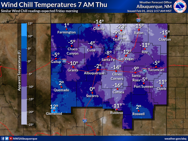
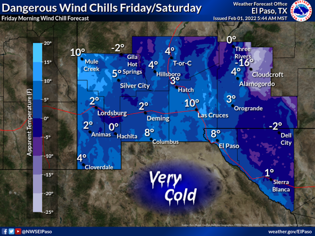
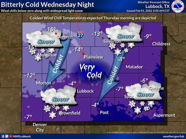
NWS Regional Wind Chill Temperature Forecasts.
Winter Storm Warnings In Effect.
(As Of 9:45 AM MST, Tuesday, February 1, 2022).
Winter Storm Watches In Effect.
(As Of 9:45 AM MST, Tuesday, February 1, 2022).
Winter Weather Advisories In Effect.
(As Of 9:45 AM MST, Tuesday, February 1, 2022).
Winter Storm Watches In Effect.
(As Of 9:45 AM MST, Tuesday, February 1, 2022).
Winter Storm Watches In Effect.
(As Of 9:45 AM MST, Tuesday, February 1, 2022).
Key Points To Rember:
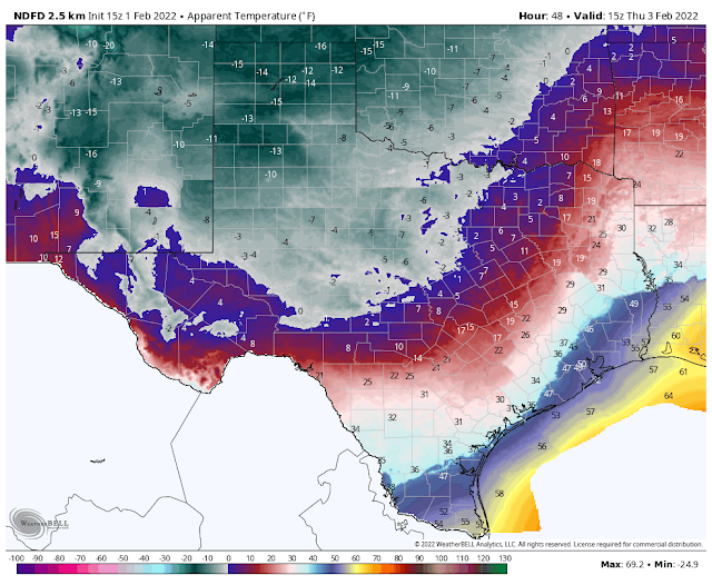
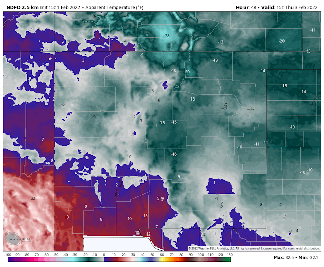
1. A Widespread Major Long Duration Winter Storm is forecast areawide that will be accompanied by bitterly cold temperatures and dangerously low wind chill temperatures (0ºF to -20ºF). A few locations may experience near-blizzard to blizzard conditions at times late Wednesday night into Thursday night...especially over and near the mountains.
2. Light to moderate snow is forecast for many areas of New Mexico and West Texas. Heavy snow will fall in the mountains and across some lower elevations of the state. Some mountain locations may measure storm total snowfall amounts by the feet not inches. Some areas across Southeastern New Mexico and West Texas may see a wintry mix of rain and freezing rain before transitioning over to all snow Wednesday afternoon continuing into Friday.
2. Light to moderate snow is forecast for many areas of New Mexico and West Texas. Heavy snow will fall in the mountains and across some lower elevations of the state. Some mountain locations may measure storm total snowfall amounts by the feet not inches. Some areas across Southeastern New Mexico and West Texas may see a wintry mix of rain and freezing rain before transitioning over to all snow Wednesday afternoon continuing into Friday.
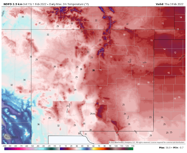
3. Many locations may not see the thermometer rise above freezing from Wednesday/Wednesday night into Saturday afternoon. Depending upon the snowfall/snow cover and how soon our skies clear, many locations could record low temperatures below zero in the Thursday through Saturday morning time frame. Some mountain communities may see readings in the -20ºF or colder range. Record low temperatures are possible in some areas.
4. Life-threatening conditions will develop on many of New Mexico's highways and roads, as well as the nearby Texas Panhandle and West Texas highways and roads Wednesday afternoon into Friday. This due to snow, heavy snow, blowing and drifting snow, icy and slick highways and roads, near-zero visibilities in whiteout conditions. Road closures are likely in many areas and some may be widespread.
5. Rescue may be next to impossible for a time in some of the harder impacted areas until the storm clears. New Mexico has a long history of stranded motorists on state highways and roadways during storms of this magnitude.
5. Rescue may be next to impossible for a time in some of the harder impacted areas until the storm clears. New Mexico has a long history of stranded motorists on state highways and roadways during storms of this magnitude.
6. Power outages will be possible in some areas due to the heavy snow, ice accumulations, and strong winds. Winter weather conditions will impact the Oil Fields of Southeastern New Mexico and West Texas with the cold temperatures, dangerous wind chills, and snow-packed roadways.
7. Livestock exposed to the weather elements without shelter will be at risk. This includes local dairies in Southeastern New Mexico. Remember to protect your pets and water pipes.
8. Be prepared for changing weather conditions and forecasts as more information becomes available Tuesday into Wednesday concerning this dangerous winter storm. Additional Winter Storm Watches, Warnings, and Advisories will likely be issued for the state and nearby areas.
9. Please stay abreast of all of our local forecasts, watches, warnings, and advisories that are being issued by our regional National Weather Service Offices listed below. Click on the links to visit their web pages.
10. Snow has already started falling across parts of New Mexico this Tuesday morning. Most of this activity will be on the light side. The brunt of the winter storm will impact the state Wednesday into Friday.
11. Snowfall totals across the Southeastern Plains of New Mexico are currently forecast to be in the 2"-4" range.
In the northern Sacramento mountains (Ruidoso area) 4"-6" with 5"-10"above 7,500'.
In the Cloudcroft and Sunspot areas 12"-16".
11. Snowfall totals across the Southeastern Plains of New Mexico are currently forecast to be in the 2"-4" range.
In the northern Sacramento mountains (Ruidoso area) 4"-6" with 5"-10"above 7,500'.
In the Cloudcroft and Sunspot areas 12"-16".
Below 7,500' to 6"-10" with 3"-5" at the lower elevations of southern New Mexico.
12. Now is the time to prepare and stock up on necessary supplies and other necessities.
12. Now is the time to prepare and stock up on necessary supplies and other necessities.
The Truth Is Stranger Than Fiction!


Comments
Post a Comment
Your comments, questions, and feedback on this post/web page are welcome.