


Late Winter Storm Brings High Winds/Blowing Dust/Some Snow.

Sierra Blanca Peak West Of Ruidoso, NM.
Blog Updated At 2:10 PM MST Monday.
Blog Updated At 4:52 PM MST Monday.
(Valid At 5 AM MST Wednesday).
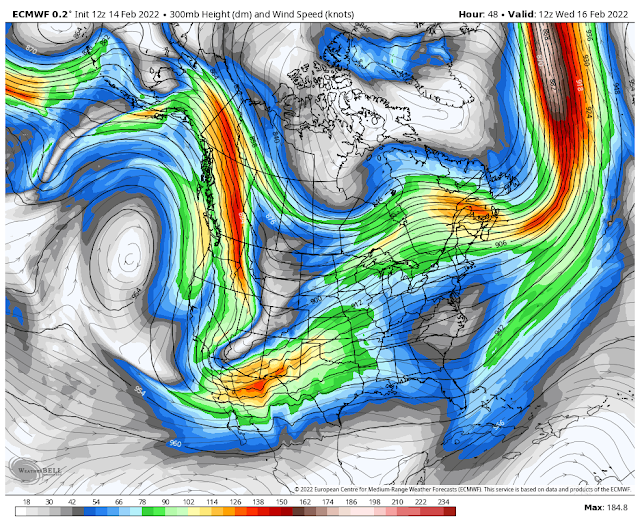
European (ECMWF) 500 MB (18,000') Forecast.
(Valid At 5 AM MST Wednesday).

Next Closed Low To Bring Winter/Spring Weather.
We are coming to the end of the 2021-2022 meteorological winter in a couple of weeks. The meteorological spring begins March 1st. La Nina has dominated our winter which has overall been warmer and drier than normal for much of New Mexico and the area.
This morning's forecast models continue the idea of a closed mid-upper level low dropping southeastward from just west of the Oregon/Washington state line as of noontime today, into Arizona late Tuesday. The European model (ECMWF) has the storm located over southwestern Arizona by sunrise Wednesday morning. The Candian (GEM) and U.S. (GFS) models are similar in their forecast location of the storm at that time.
The Euro has the mid-level closed low then sweeping eastward across southern New Mexico near El Paso by sunset Wednesday as it opens up and weakens. The second lobe of energy is then forecast to swing southeastward across New Mexico Thursday into Friday morning. There yet may be some changes in the storm's forecast track and speed.
(Valid At 5 PM Wednesday).

A Pacific cold front will move east across the region Tuesday night into Wednesday night. A back door cold front will move south through the area Wednesday night behind the Pacific front.
Temperatures ahead of the cold fronts will be warm today and Tuesday with most areas seeing highs in the low 70's. Some locations across southeastern New Mexico and parts of West Texas may reach 80ºF or close to it Tuesday afternoon. Back down into the low 70's on Wednesday and only the 40's on Thursday in the colder air.
The Ruidoso area will see highs today and Tuesday near 60ºF. Cloudcroft will be in the upper 40's. As colder air settles in Thursday the mountains will see highs drop down into the upper 20's in the Cloudcroft area and the upper 30's in the Ruidoso area. Lows Friday morning will be cold with readings in the teens and maybe some single digits.
Today.


Tuesday.


Wednesday.


Thursday.


High Winds & Blowing Dust.


With a tight surface pressure gradient forming ahead of the approaching Pacific cold front strong winds are likely across the area beginning Tuesday afternoon. The strongest winds will occur on Wednesday into Wednesday evening.
Across the southeastern plains and other lower elevation locations across the area, southwesterly winds will increase to sustained speeds of 20-30 mph with gusts near 40-50 mph across the lower valley locations Tuesday afternoon. On Wednesday these winds will increase to 25-35 mph with gusts near 50 mph or higher.
Across the Sacramento and Capitan Mountains nearby locations, southwesterly-westerly winds will increase to sustained speeds of 20-35 mph with gusts near 40-55 mph Tuesday afternoon. On Wednesday these winds will increase to 25-40 mph with gusts near 50-60 mph or higher.
A High Wind Watch remains in effect for the Guadalupe Mountains of Eddy County and West Texas for Wednesday morning through Wednesday evening. Southwest-westerly winds are forecast to increase to sustained speeds of 25-35 mph with gusts near 40-50 mph Tuesday afternoon. Southwesterly-westerly winds are forecast to increase to sustained speeds of 40-60 mph with gusts near 75 mph on Wednesday.
Depending upon the exact location of the strongest mid-upper level winds Wednesday afternoon some areas could see higher wind gusts than currently are forecast.
Blowing Dust Wednesday.

Late winter storms are notorious for their associated high wind and blowing dust storms locally. This next winter storm looks to uphold that tradition across southern, south-central, eastern, and southeastern New Mexico Tuesday afternoon into Wednesday. The highest winds and worst blowing dust storms will occur Wednesday.
Areas of localized blowing dust will occur Tuesday afternoon but more so on Wednesday. Widespread areas of blowing dust will be possible late Wednesday morning into Wednesday evening.
Sudden drops in the visibility to less than one mile will occur over and near our normally dust-prone areas such as freshly plowed farmlands, fields, open lots, and highway construction sites. In the highest gusts (above 60 mph) the visibility could drop down to near zero with little to no warning in these dust-prone areas.
Critically Dangerous Fire Weather Conditions!


Critically Dangerous Fire Weather Conditions will develop over the areas highlighted in red on the map above on Wednesday. Combine the expected high wind event, single-digit humidity values, and the ongoing drought then you have a recipe for wildfires. Any wildland, grass, or forest fire that should develop on Wednesday will have the potential to rapidly spread and grow in the above-mentioned conditions. Any type of outdoor activity that involves the use of sparks or flame should be avoided Tuesday into Wednesday.
(Tuesday - Thursday).

ECMWF Storm Total Snowfall Forecast.
(Tuesday - Thursday).

(Tuesday Night - Thursday Morning).


Most locations across New Mexico are slated to see at least some light rain and snow showers from this advancing winter storm. It like most of the winter storms this season has been fairly starved for moisture. Some moderate amounts of snow could fall over parts of New Mexico's higher northern mountains but overall this one will be rather disappointing.
Across the Sacramento and Capitan Mountains, current forecasts (as of 1:30 PM Monday afternoon) indicate that this storm will drop an inch or less of snow.
Across the Sacramento and Capitan Mountains, current forecasts (as of 1:30 PM Monday afternoon) indicate that this storm will drop an inch or less of snow.
The Truth Is Stranger Than Fiction!


Comments
Post a Comment
Your comments, questions, and feedback on this post/web page are welcome.