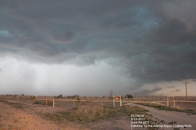
Artesia, New Mexico Shelf Cloud 5-13-2012.
Click On The Photos To Enlarge Them.
A cluster of thunderstorms northwest of Roswell, New Mexico moved southeast into northwestern Eddy County, northwest of Artesia late Sunday afternoon. As the these thunderstorms neared the Cottonwood area, northwest of Artesia, they formed a line of thunderstorms, which bowed out and produced damaging winds, large hail, heavy rain and street flooding as the line moved southeastward into the Carlsbad area by 8 PM MDT.
I took my wife (Diane) and our 14 year old daughter (Kaytlyn) chasing with me yesterday. The day started out slow, with not much happening in southeastern New Mexico until late in the afternoon. Kaytlyn was not happy about going at first, but she got really excited once the storm started approaching from the northwest, and she shot tons of pictures of the shelf cloud when we were west of Artesia. Diane saw a road runner while we were camped out north of Artesia on the Eddy/Chaves County line waiting for the storms. She was disappointed that she did not get to see her wall cloud or tornado yesterday, but she was happy about the shelf cloud. She got a little worried when we got rocked a couple of times by the 60+ mph straight line gusts, and the nickel to quarter size hail south of Artesia, and at Brantely Lake State Park. Blinding sheets of rain dropped the visibility down to less than 100 yards a couple of times during those encounters.
When this line of thunderstorms bowed out northwest of Artesia it produced a beautiful shelf cloud, and lots of scud clouds. I got a ton of calls on this. Shelf clouds never produce tornadoes, and scud clouds are not tornadoes.
As has been typical of this year, I had a multitude of problems centered around Skywarn Operations. These ranged from repeater problems, (I could hear Net Control at the Midland National Weather Service Office at times, but they could not hear me, and visa versa). A multitude of cell phone problems, (got a ton of calls about the scud clouds and shelf cloud) I don't know how many calls I dropped, or missed, because my service kept going in and out. My live stream feed kept dropping out, which was driving me crazy, but at least my AT & T air card behaved fairly well this time. I was happy that I was able to stay on NWS Chat, and keep my radar feeds up (GRLevel3 and GRLevel-AE). At least on this chase I wasn't totally blind as has been the case on other chases so far this year.
Of course when I wen to activate Skywarn Operations here in Eddy County I ran into more problems with the DCC Communicator Next System, it never would let Joel Arnwine (the Eddy County Emergency Manager) or I issue the Skywarn Spotter notifications for Eddy County. He is aware of the problem with the system and continues to work on getting the issue resolved. He also tried linking in the Counties five new amateur radio repeaters into the West Texas Connection, but that too failed. This season has been fraught with these types of technical issues, this is appropriate since we haven't had any severe weather in two years. I apologize to everyone trying to call me, it was simply a lousy day for communications!
Spotter Reports From Yesterday's Storms.
The Truth Is Stranger Than Fiction!
My Web Page Is Best Viewed With Google Chrome.


I couldn't have really asked for a much better blog. You are always at hand to provide excellent information, going straight away to the point for easy understanding of your subscribers. You're really a terrific pro in this arena. Many thanks for remaining there humans like me.
ReplyDeleteHTTP://www.KneeNeckBackPain.com/