Why Are My Weather Posts Missing From Facebook.

Hello everyone. I just wanted to let you know that my Facebook page was shut down without any warning by Facebook this past Saturday, June 8th. All I was told was that I had violated their community standards. I don't know what triggered that; they didn't tell me. I was told this may be permanent or for six months.
My guess is that it may be because I posted several comments and articles from my Substack page about the riots in LA, and that must have triggered/angered someone, and they complained, thus Facebook shut me down. I don't know this as fact, though. I have appealed this decision, and I'm still waiting for their reply. I have read on X that this has happened to other Facebook users posting about the LA riots as well.
I always share my weather blog posts (that I post here) on my Facebook page and my X page. This included over twelve different New Mexico and West Texas Facebook Community sites. So there are thousands of you out there (based on my views and shares of those posts) who will no longer see those posts. My Facebook page may or may not be restored.
This is another good reason (as the National Weather Service often reminds us) to have multiple ways of receiving severe weather alerts when severe weather threatens your location. My weather web page is one of those ways, and I really appreciate all of you who have and still do use it. Thank you so much!!!
If my Facebook page is restored, I will continue to share my weather blog posts and some of the NWS Watches and Warnings...as I have been doing for years now.

Cooler With Scattered Severe Thunderstorms Today!


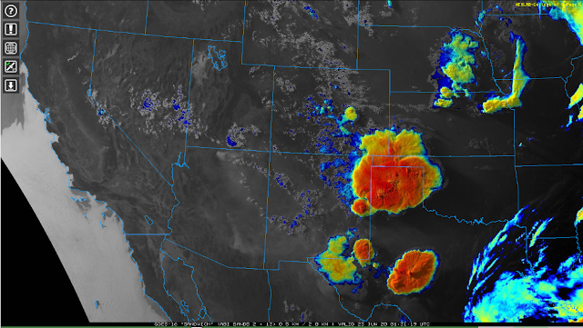
At 7:31 PM MDT Monday, June 22, 2020.

     Several complexes of thunderstorms (MCS) develop yesterday afternoon. The largest formed over northeastern New Mexico and the Texas Panhandle. The second near the Midland-Odessa area. A small cluster of Severe Thunderstorms developed near Hobbs and along the east slopes of the Sacramento and Guadalupe Mountains.


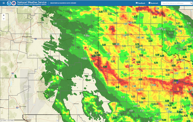
Valid At 5:30 AM MDT Tuesday, June 23, 2020.

     Heavy rainfall fell over far eastern New Mexico in the Clovis area yesterday afternoon. As well as parts of the Texas Panhandle and West Texas.


Sunday.

  
Monday.


     Sunday ended up being hotter locally than Monday was. I recorded my highest temperature so far this summer season on Sunday with a reading of 107ºF, and 106ºF on Monday here at our home in Carlsbad, New Mexico. The Roswell Airport reported 107ºF on Sunday and 105ºF on Monday. The Carlsbad Airport recorded 105ºF on Sunday and 104ºF on Monday. 

Severe Thunderstorms Today!


     Scattered thunderstorms are forecast to break out across the area today. Some of these are going to become severe and will be capable of producing large hail (possibly golf ball size or larger), damaging thunderstorm wind gusts in excess of 60 mph, and deadly cloud to ground lightning. Locally heavy rainfall along with isolated localized flash flooding may also occur with the strongest thunderstorms. Our chances for seeing measurable rainfall in SE NM today into tonight ranges from 20% to 50%.

    Today will also see cooler temperatures as we struggle to reach the upper 80's to near 90ºF. Thanks to a cold front that moved south through the region last night.

Comments

NWS Albuquerque Burn Scar Matrix

Current National Weather Service Watches/Warnings In Effect.

New Mexico

Chaves County Plains & Mtn's

Eddy County

Culberson County

Lea County

Lincoln County

Otero County

Current US Temps

Current US Wind Chill/Heat Index Temperatures

WPC 7-Day Precipitation Forecast

Roswell Live EarthCam

Ruidoso Live Webcam

Cloudcroft Live Webcam

NWS Midland 3-Day Precipitation Forecast

NWS Midland 3-Precipitation Chances

New Mexico 3-Day Precipitation Forecast

New Mexico Precipitation Chances

NWS El Paso 3-Day Precipitation Forecast

NWS El Paso Precipitation Chances

US 24-Hour Precipitation Forecast

US 3-Day Precipitation Forecast