

Major Winter Storm Bearing Down On New Mexico!
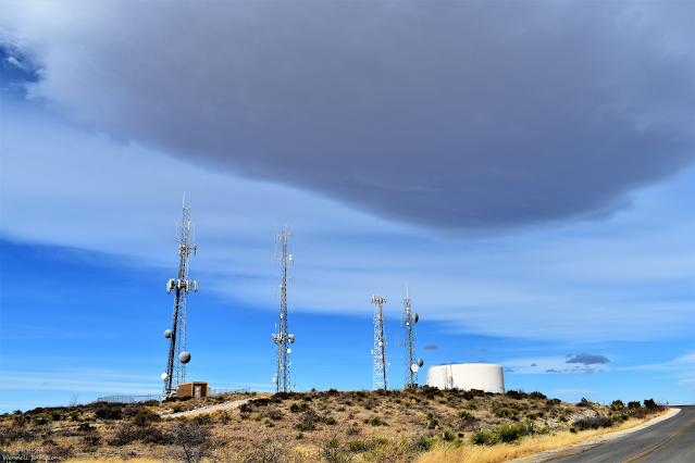
December 26, 2021.
Carlsbad, New Mexico.
Stacked Altocumulus Standing Lenticular Clouds.
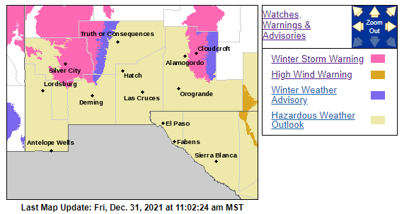
Winter Storm Warnings & Winter Weather Advisories Cover Much Of New Mexico This New Year's Eve Morning!
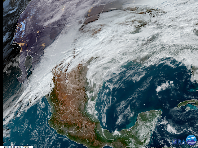
GeoColor Image.
( At 9:26 AM MST This Morning).
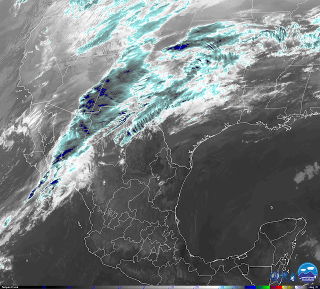
IR Image.
( At 8:36 AM MST This Morning).
(At 8 AM MST This New Year's Eve Morning).

Near Record Amounts Of Mid-Level Moisture Headed Our Way.
For a couple of days now I've been talking about the closed low located just west of the Baja Region this morning. The map above shows the 500 MB (18,000') low (Red L), the mid-level moisture plume (blue colors), the pressure isobars (equal lines of pressure), and the 18,000' winds at 8 AM MST.
Looking at the GeoColor and IR satellite images above clearly shows this deep subtropical moisture fetch be pulled northeastward into New Mexico and nearby areas by the southwesterly 50-70 knot or 58-81 mph winds.
Local Radar Snapshots.


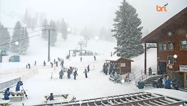
Ski Apache (Live Cam Snapshot).
(10:52 AM MST).

(As Of 9 AM MST This Morning).

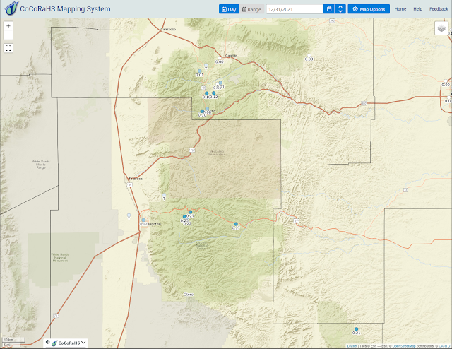
24-Hour Rainfall Amounts As Of 10:30 AM MST).


(As of 10:30 AM MST).
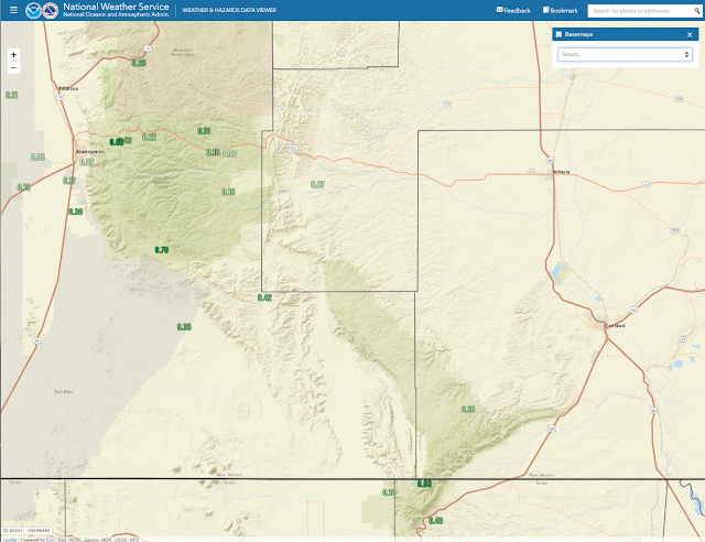
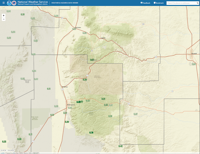
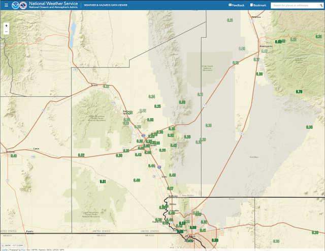
Moderate to heavy rain has fallen overnight into this morning across southern New Mexico. Reported 24-hour rainfall totals are ranging from a .25" up to 1.25". Heavy snow is currently falling at Ski Apache with a couple of inches already accumulating. Light rain is currently falling in Carlsbad (as of 10:55 AM MST) and Roswell. Light rain is falling in Ruidoso. Light rain is also falling in Queen, El Paso, Alamogordo, and moderate rain is falling in Guadalupe Pass. No current reports from Cloudcroft with the webcam down but CoCoRaHS observers reported .5" to 1.2" of snow overnight. This is going to be a wet storm for sure.
Much of New Mexico is under Winter Storm Warnings and Winter Weather Advisories. Except for the valley locations of Eastern, Southeastern, Southern, and parts of Central New Mexico. Please visit my Weather Web Page via this link for additional information across the state and nearby areas.
Much of New Mexico is under Winter Storm Warnings and Winter Weather Advisories. Except for the valley locations of Eastern, Southeastern, Southern, and parts of Central New Mexico. Please visit my Weather Web Page via this link for additional information across the state and nearby areas.
Heavy To Very Heavy Snow In The Mountains!
(Valid Today Through 5 PM MST Sunday).
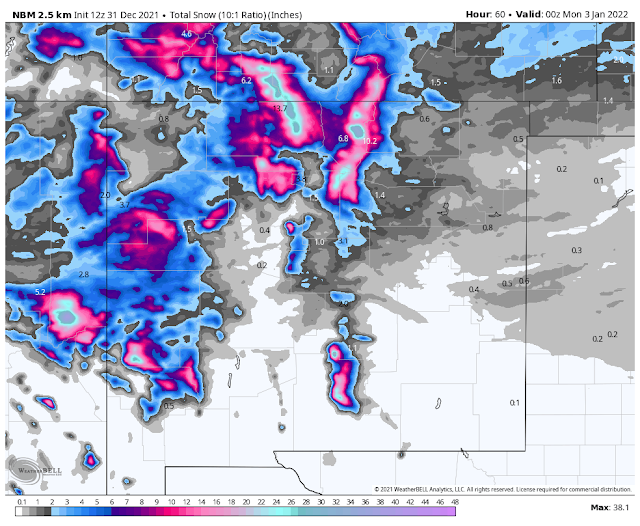

Latest forecast model data continues to bring our winter storm in slower, stronger, and a tad further south. So the mountains are just going to get clobbered by this one...especially above 8,000'. Model forecasts hint at 24" to 30" at Ski Apache, 12" to 18" in the Cloudcroft, Sunspot, Silver Lake areas, and 8" to 12" above 7,500' in the Ruidoso area.
Blowing and drifting snow in the Sacramento and Capitan mountains will cause travel problems born upon the 50-60 mph southwesterly wind gusts today into New Year's Day. Expect whiteout conditions during the highest gusts with near-zero visibility. Road closures are also expected.
Dangerous wind chill values below zero (0ºF to -20ºF) are expected today into Sunday morning. If you don't have to travel in the mountains of the state and local area then please just sit this one out if you are able.
Light to occasional periods of moderate rain will occur today into New Year's morning. Total rainfall will range from near a tenth of an inch to maybe a half of an inch in places...especially near the foothills and mountains.
A High Wind Warning remains in effect for the Guadalupe mountains this evening through New Year's Evening. West winds sustained at 50-65 mph with gusts near 85 mph are forecast. Additional High Wind Watches/Warning and or Wind Advisories are possible for the local area later today into New Year's Night.
If we get the rain then our winds will be minimized somewhat here on the Southeastern Plains and parts of West Texas...as will the blowing dust on New Year's. If not, then tonight into New Year's Day has the potential to be ugly with southwesterly to westerly gusts of 60 to 70 mph possible. If we don't get the rain and the wind gust this high then will have a significant blowing dust event with the possibility of damages with the higher gusts.
The Truth Is Stranger Than Fiction!


.png)


Total rainfall through 0700 hrs here in NE El Paso, 1.25” in the past 2 days (0.45 & 0.80”) posted to cocorahs.
ReplyDeleteWow! That pretty incredible for this time of the year. We have only had .07" here at our home in Carlsbad.
ReplyDelete