High Winds/Blowing Dust & Extreme To Historical Fire Danger Today!
Blue 2 Fire - Slurry Drop.
Northwest Of Ruidoso, NM.
Extreme To Historical Fire Danger Today!
Every single county in New Mexico is under Red Flag Warnings today...something that you don't see very often. Extreme to Extremely Critically Dangerous Fire Weather Conditions are in place across a large part of the state.
With hundreds of thousands of people celebrating the Memorial Day Holiday weekend outdoors today through Monday, it is imperative that extreme caution be exercised when it comes to any outdoor activities that will create a spark or flame!
The best practice given the current extreme fire danger across much of the state is...don't engage in any outdoor activity that will create sparks or flames today into Monday. I know this will upset some but the stakes are simply too high to risk an accidental fire developing.
Any wildfire, forest fire, grassland, or range fire will have the ability to rapidly spread and grow and develop into a life-threatening event today and Sunday. See the wording from the Albuquerque and El Paso National Weather Service Offices in their Area Forecast Discussions (AFD's) written early this Saturday morning.
High Wind Warnings and Wind Advisories are in effect today for much of the state. Southwest to westerly winds will increase to sustained speeds of 25-40 mph with gusts in the 55-75 mph range. See the associated links or my web page for specific details.
Areas of blowing dust will also develop this afternoon and evening during the strongest winds. Localized visibilities may suddenly drop down to near zero with little to no advanced warning in our normally dust-prone locations such as: Freshly plowed or cultivated farm lands, open or exposed fields and lots, and along and near highway construction sites.
Beware of smoke from the current forest fires or any new spreads or developments reducing the local visibility in affected areas which may affect localized travel in and near fires.
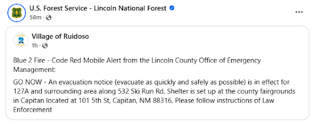
Of particular concern is the Sacramento and Guadalupe Mountains including all of the Lincoln National Forest Lincoln National Forest. The situation in the Bonito Lake area northwest of Ruidoso is already very bad with the spread of the Blue 2 Forest Fire and has likely get much worse today into Monday.
Additional evacuation orders have been issued by local authorities in Lincoln County early this Saturday morning for the following areas. 127A and surrounding areas along 532 Ski Run Rd. The Blue 2 Fire continues to spread and grow in spite of numerous fire suppression efforts yesterday including aerial slurry drops. Please heed all local evacuation orders in the affected areas.
There Are None So Blind As Those Who "Will - Not" To See...107.


Comments
Post a Comment
Your comments, questions, and feedback on this post/web page are welcome.