Posts

Showing posts from February, 2016

Our Break From Spring Like Weather Is Over - Winter Has Returned.

Image
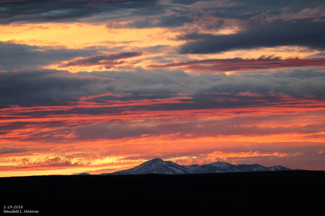
Sierra Blanca Peak At Sunset Friday, February 19, 2016.  Regional Radar @ 9:31 MST This Morning. NWS Precipitation Analysis As Of 5 AM MST This Morning. 24-Hour Rainfall Totals As Of 9 AM MST This Morning. 24-Hour Lightning Strike Summary As Of 9:30 AM MST This Morning. 24-Hour Reported Peak Wind Gusts. As Of 9 AM MST This Morning.  As of 9 AM MST this morning a mid-upper level low was centered near Wichita Falls, Texas with a trough of low pressure and embedded disturbances located over New Mexico behind the storm. This is the storm that has produced the snow and rain over the state since yesterday. A broken line of thunderstorms developed late yesterday afternoon across the Tularosa Basin and extended northeastward into northeastern New Mexico. This line of storms moved southeastward along and ahead of a cold front and into southeastern New Mexico early yesterday evening, producing frequent cloud to ground lightning strikes, light to moder

You Know When Its 91°F In February In NM Something Is Up. It Is - Winter Returns Mon & Tue.

Image
Sierra Blanca Peak At Sunset 2-19-2016. Canadian (GEM) Forecasts. 500 MB Forecast Valid @ 5 AM MST Tuesday, February 23, 2016. Temperature Forecast Valid @ 5 PM MST Tuesday, February 23, 2016. Storm Total Rainfall Forecast Valid @ 11 PM MST Tuesday, February 23, 2016. Accumulated Snowfall Forecast Valid @ 11 PM MST Tuesday, February 23, 2016. WPC Accumulated Snowfall Forecast. Valid @ 5 AM MST Wednesday, February 24, 2016. This past Thursday was a rather remarkable day for the local area. Roswell topped out with a high temperature of 91°F  at the Airport which not only established a record high for the day (beating the old record of 83°F in 1986) but also established a new all time high for the month of February (beating the old record of 88°F set on Feb 24, 1904). This was also the earliest that Roswell had reached 90°F beating the previous record of 90°F on March 2, 1967. \ Here in Carlsbad I recorded a high temperature of 90°F last

Ridiculously Warm Today - Downright Hot On Thursday.

Image
Temps Today & Thursday 15°F-25°F Above Normal. Forecast Temperature Anomalies Today @ 5 PM MST.  Forecast High Temps Today. Forecast High Temps Today. Thursday's Outlooks. Forecast Temperature Anomalies Thursday @ 5 PM MST.. Forecast High Temps Thursday. Forecast High Temps Thursday. Local NWS 7-Day Forecasts. Hot, dry, and a bit on the windy side will characterize Thursday's weather across much of the area. A few spots are going to flirt with the 90°F mark believe it or not.  Today's will be abnormally warm as well with highs mostly in the mid-upper 70's. A Fire Weather Watch has been issued for southeastern New Mexico and nearby areas for Thursday. The Truth Is Stranger Than Fiction!

Warm Week Ahead - Record High Temps Possible Wed & Thu.

Image
Temperature Anomaly Forecast. Valid @ 5 PM MST Thursday, February 18,2016. NWS Albuquerque Forecast Highs/Records Thursday. Forecast High Temperatures Today. Forecast High Temperatures On Tuesday. Forecast High Temperatures On Wednesday. Forecast High Temperatures On Thursday. Forecast High Temperatures For Friday. NWS Forecasts This Week. High temperatures across the area this week will continue to remain above normal. By Thursday which is forecast to be the warmest day of the week locally our highs will be running some 15°F to 25°F above normal. Notice that the GFS model is even forecasting a high of 90°F in the Wink/kermit/Pecos, Texas area on Thursday.  Many locations will likely tie or break their daily high temperature records on Wednesday and more so on Thursday. Rather unusual for the middle of February but not totally unheard of. Local Record High Temps For Thursday, Feb 18, 2016.

Solar Cycle #24 Lowest Activity In 200 Years.

Image
Current Image Of The Sun - February 13, 2016.  Our big bright yellow star continues to exhibit lower than average sunspot activity as solar cycle #24 comes to a close in a couple of years. The sunspot number in January was 56.6, which is 71% of the mean this far into the period, calculated using the 23 previously measured solar cycles. The current level of solar activity with solar cycle #24 is being compared to solar cycle #5 which occurred in the beginning of May 1798 and ended in December 1810 (thus falling within the Dalton Minimum 1790-1830 ). Weakest Solar Cycle In More Than A Century Now Heading Towards The Next Solar Minimum.  "The current solar cycle, #24, is the weakest solar cycle in more than a century and it is now heading towards the next solar minimum phase which would be the beginning of solar cycle #25.  The last solar minimum phase lasted from 2007 to 2009 and it was historically weak. In fact, it produced three of the most spotless days on t

Current Watches In Effect

Storm Prediction Center (SPC) Day 1 Severe Weather Outlook

SPC Mesoscale Discussions

Current NWS National Watches/Warnings In Effect

Current NWS National Watches/Warnings In Effect
Click On The Map For The Latest Updates

New Mexico

NWS Regional Radar

NWS Regional Radar

GOES-East - Sector view: Southern Rockies - GEOColor

Current US Temps

Current US Wind Chill/Heat Index Temperatures

NWS Midland Radar

NWS Midland Regional Forecast

NWS Midland Regional Forecast

NWS Midland Regional Forecast

Cannon AFB Radar

NWS Albuquerque Radar

NWS Albuquerque Regional Forecast

NWS Albuquerque Regional Forecast

NWS Albuquerque Regional Forecast

NWS Albuquerque Regional Forecast

Holloman AFB Radar

NWS El Paso Radar

NWS El Paso Regional Forecast

NWS Lubbock Radar

NWS Lubbock Regional Forecast.

NWS Lubbock Regional Forecast

NWS Lubbock Regional Forecasts

NWS Lubbock Regional Forecast

NWS Forecast High Temps Today

NWS Forecast Low Temps Tonight

24-Hour Minimum Wind Chill Forecast

NWS Albuquerque Storm Total Snowfall Forecast

NWS Albuquerque Storm Total Rainfall Forecast

NWS Midland Storm Total Rainfall Forecast

NWS El Paso Storm Total Rainfall Forecast

Average Daily High/Low Temperatures & Rainfall

Average Daily High/Low Temperatures & Rainfall