Posts

Showing posts from February, 2020

Say Goodbye To Winter & Hello To Spring.

Image
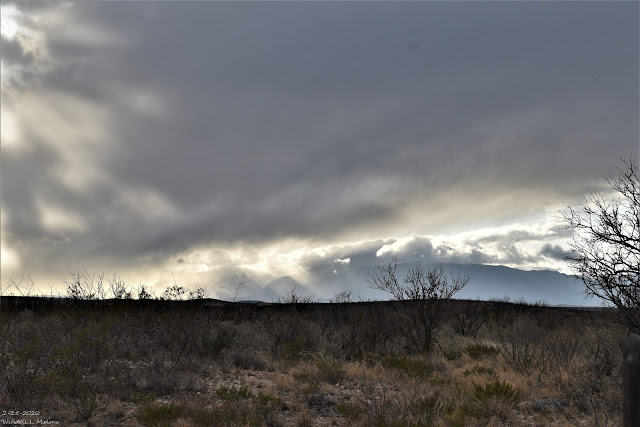
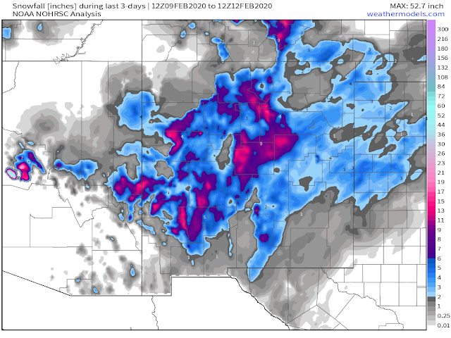
Blog updated at 5:35 PM MST Saturday. 2-25-2020. Parting Storm Over The Guadalupes. Say Goodbye To The Meteorological Winter Of 2019-2020. As I sat down at my desk to write this blog this morning this song came to mind. Change the words a little from "Tuesday's gone with the wind" to "winters gone with the wind" and you see where I'm coming from.  Today's (Saturday, February 29th, 2020) is the last day of our meteorological winter. Sunday marks the beginning of our meteorological spring. Here in Southeastern New Mexico, our winter is ending up somewhat on the dissapointing side as far as cold and snow are concerned.  Here at our home in Carlsbad, New Mexico I recorded 1.08" of rainfall from December 1st, 2019 through February 29th, 2020. My seasonal snowfall stands at 4.8". February has been wet with .70" of rainfall.  My highest recorded daily high temperature this winter was 79Āŗ which occurred on January 14th...

Windy Sunday!

Image
Airmass Satellite Image. At 8:21 AM MST This Saturday Morning. A very long fetch of subtropical moisture stretches from well south and southwest of Hawaii this morning northeast into the Desert Southwest including New Mexico. Looking at local airport observations this cloud deck is generally located at the follow heights above ground level: 10,000', 14,000' 17,000', 21-22,000'. There are lower clouds north and west of SE NM. Needless to say, a very moist airmass located at the mid and high levels of the atmosphere is being pulled into the area by a closed mid-upper level low located at the 18,000' level just northwest of San Diego, CA at sunrise this morning. This is depicted in the graphics below. GFS 500 Millibar/18,000' Forecast. Forecast Valid At 2 PM MST Sunday. Forecast models this morning are in good agreement that this closed low off the California Coast will move eastward today into Sunday. By sunset Sunday it will be ex...

Winter Is Back.

Image
January 11, 2020. South Of Cloudcroft, New Mexico. Nothing compares to the peaceful serenity of a winter-time snowscape.  Winter Is Back.  European (ECMWF) Model's 500 Millibar/18,000' Heights Forecasts. Analysis At 11 AM MST This Wednesday Morning. A short wave trough of low pressure at 18,000' up in the atmosphere will swing southeast tonight into Thursday and then lift northeast out of the area by Friday morning. As it does it "kick" a strong cold front south into the area by sunrise Thursday morning. See the surface map forecast below. Much colder air will then overspread the state and local area into Friday. Forecast For 5 PM MST Thursday. Forecast For 5 PM MST Friday. Forecast For 5 PM Saturday. Forecast For 5 AM MST Sunday. Should the "next little bowling ball", that's what I call them, storm roll a tad further south than the models think then we could have a wetter and stormier ...

New Mexico Reported Snowfall Totals - Wednesday, Feb 12, 2020.

Image
Blog Updated At 4:16 PM MST Wednesday. New Mexico Snowfall Total Maps. Past 3-Days. February-To-Date.  (1st-12th). Season-To-Date Totals. (Oct 1st, 2019 - Feb 12th, 2020). Texas Season-To-Date Totals. (Oct 1st, 2019 - Feb 12th, 2020). Snow Cover This Wednesday Morning. Today's MODIS Satellite Images. Look closely and you can pick out the snow cover band over the Guadalupe's with a streak of snow extending northeast to Brantley Lake and then on to Loco Hills this morning. Another band runs from just southwest of the Hagerman area northward through Roswell and the Bitter Lakes Wildlife Refuge. Widespread snow cover is evident over the Capitan and Sacramento mountains, and west of Tatum northward over the Eastern Plains. RAMMB/CIRA Satellite Image. (Day Snow/Fog False Color Image). Areas shaded red indicate snow cover this Wednesday morning, and areas shaded in white are clouds. Green is the ground. Ne...

Current National Weather Service Watches/Warnings In Effect.

New Mexico

Chaves County Plains & Mtn's

Eddy County

Culberson County

Lea County

Lincoln County

Otero County

Current US Temps

Current US Wind Chill/Heat Index Temperatures

WPC 7-Day Precipitation Forecast

Roswell Live EarthCam

Ruidoso Live Webcam

Cloudcroft Live Webcam

NWS Midland 3-Day Precipitation Forecast

NWS Midland 3-Precipitation Chances

New Mexico 3-Day Precipitation Forecast

New Mexico Precipitation Chances

NWS El Paso 3-Day Precipitation Forecast

NWS El Paso Precipitation Chances

New Mexico 3-Day Snowfall Forecast

New Mexico Snowfall Chances

NWS El Paso 3-Day Snowfall Forecast

NWS El Paso Snowfall Chances

US 24-Hour Precipitation Forecast

US 3-Day Precipitation Forecast

US 24-Hour Snowfall Forecast

US 3-Day Snowfall Forecast