Posts

Showing posts from June, 2021

My Blog Archive List (July 2010 - August 2025).

Show more

Viewing My Web Page

If you are viewing my web page on your cell phone, then be sure and click on the three white bars located in the top left-hand corner of the page (only visible on your phone). This is the menu bar, and it opens up additional links and graphics. Such as forecast maps, severe weather outlooks, current conditions, radar and satellite links, and more.

Flash Flood Watches Remain In Effect - Another Historic Flash Flood Event Shaping Up?

Image
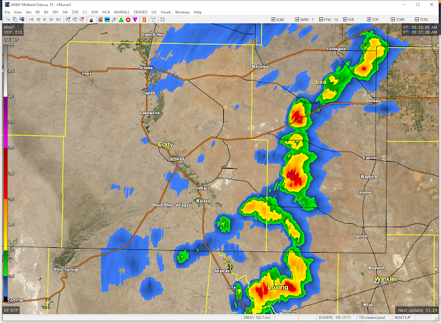
6-26-2021. Cumulonimbus Cloud. Looking East At Brantley Lake Dam. GRLevel3_2.0. NWS Midland Doppler Radar. 24-Hour Estimated Rainfall Totals. GRLevel3_2.0. Cannon AFB Doppler Radar. 24-Hour Estimated Rainfall Totals. 24-Hour MRMS Rainfall Totals. New Mexico Mesowest 36-Hour Rainfall Totals. CoCoRaHS 24-Hour Rainfall Totals. Weather Underground 24-Hour Rainfall Totals. Thunderstorms moved from northwest to southeast early this morning (around 3:30 AM MDT) and into the Carlsbad area. A Personal Weather Station (PWS) reported 1.91" in the north La Huerta area of town. While on the southern end the Carlsbad Airport only reported a trace of rain. Demonstrating once again how a thunderstorm can be either feast or famine with its associated rainfall.  West Texas Mesonet 24-Hour Rainfall Totals. Lamesa, Texas Gets Slammed. Lamesa, Texas had 88 mph thunderstorm wind gusts, a tornado nearby, large hail, downed trees, power lines, and widespread street flooding were reported. Very heavy rain...

Widespread Significant Heavy Rainfall Event Shaping Up!

Image
5-31-2021. South Of Roswell, New Mexico. Flash Flooding From 3" - 6" Of Rainfall. Computer Model Storm Total Rainfall Forecasts. ECMWF. Valid This Afternoon - 6 PM MDT Tuesday, June 29, 2021. GFS. Valid This Afternoon - 6 PM MDT Tuesday, June 29, 2021. WPC. Valid This Afternoon - 6 PM MDT Tuesday, June 29, 2021. National Weather Service (NWS). Valid This Afternoon - 6 PM MDT Tuesday, June 29, 2021. ECMWF 10-Day Rainfall & Temperature Forecasts. RTMA Temperatures. At 4:15 PM MDT Saturday, June 26, 2021. Hurricane Enrique IR Satellite Image. At 3:41 PM MDT Saturday, June 26, 2021. NHC Eastern Pacific Hurricane Enrique Forecast Track. Widespread Significant Heavy Rainfall Event Shaping Up! Everything appears to be coming together for a rather significant cool down and an extended period of heavy rainfall for the area. We will have to watch what happens to the moisture that Hurricane Enrique potentially could send northward into the region this upcoming week. If anything his ...

Drought Busting Rains Coming Along With Major Heat Relief!

Image
NWS Midland GRLevel3_2.0. (Storm Total Rainfall Estimates). Cannon AFB GRLevel3_2.0. (Storm Total Rainfall Estimates). NWS MRMS Storm Total Rainfall. Locally Heavy Rain Has Already Fallen. Thunderstorm activity picked up Wednesday afternoon and increased somewhat yesterday afternoon. A couple of severe thunderstorm warnings were issued for a broken line of thunderstorms that formed west of the Hobbs and Eunice areas Thursday afternoon. Local radar estimates indicate that maybe 3.50" of rain fell in a few spots west and southwest of Hobbs. This may be a little high due to hail contamination in the radar returns. Major Changes Coming In Our Weather. ECMWF 500 MB (18,000' MSL) Forecast. Valid At 6 AM MDT Monday, June 28, 2021. Surface Map Forecast. Valid At 6 PM MDT Saturday, June 26, 2021. A significant pattern change will usher in much cooler weather along with widespread heavy to very heavy rains this weekend into next week. A mid-upper level trough of low pressure is forecast...

Current US Hazardous Weather Watch/Warning Map

New Mexico

Texas

Eddy County

Guadalupe Mtns Eddy & Culberson County

Chaves County Plains & Mtn's

Lea County

Lincoln County

Otero County

🔴 Live 24/7 National Weather Radar & Alerts, Weather Intensity Score & YallBot!

Mr. Weatherman

Weatherman Plus

2025 -2026 Winter Outlook

Ruidoso Live Webcam

Ski Apache Webcam Live Link

Ski Apache Webcam Live Link
Click On The Image To Open It Up

Cloudcroft Live Webcam

Roswell Live EarthCam

Average Daily High/Low Temps & Precipitation

Average Daily High/Low Temps & Precipitation

My Precipitation Totals - 2.1 NNW Downtown Carlsbad

My Precipitation Totals - 2.1 NNW Downtown Carlsbad

My Top 10 Most Popular Posts

Artesia, NM Mothership Supercell Thunderstorm. 9-17-2016.

Monster Of A Snowstorm Coming This Christmas Weekend?

Powerful Winter Storm Is Hammering New Mexico! Worst Is Yet To Come.

25th Anniversary Of The Carlsbad, NM (May 31, 1991) Tornado Coming Up.

Major Winter Storm May Paralyze/Bury Parts Of NM & Nearby Areas Tonight Into Wednesday!

2011 Skywarn Spotter Training Classes & My Thoughts.

Tonight's GFS Is As Drunk As This Mornings ECMWF. Historic Snowstorm Next Weekend?

Are We Fixing To Go From Drought To Flood In SE NM?

Major Winter Storm To Hammer New Mexico & West Texas Thanksgiving Week!

Cloudcroft & Ruidoso, NM Seasonal Snowfall Totals.

My Favorite Blog List.

Substack

Disclaimer

This blog and its contents are for informational purposes only! Always have multiple sources of information available to rely upon during severe weather. Do not rely solely on the Internet. Be weather-aware, plan ahead, have a backup plan, and be ready to act before severe weather strikes your location.