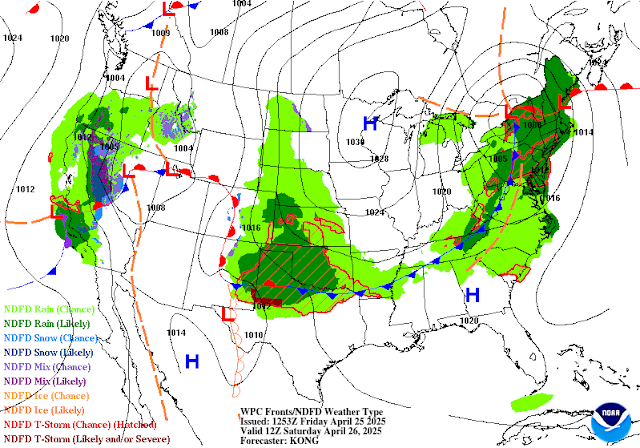
Severe T-Storms E/SE NM Today & Saturday - High Winds/Blowing Dust/Dangerous Fire Weather Conditions Sunday.
Alamagordo, New Mexico.
A strong spring closed upper-level low was centered southwest of Portland, Oregon, early this morning. It is forecast to slowly drift to the south and southeast today into late this weekend, and by Sunday evening,g it should be located over northern Utah.
At the surface, the dryline had backed as far west as the eastern slopes of the Guadalupe, Sacramento, and Capitan mountains. With surface dew point temperatures about as rich as you get in April (mid to upper 60's). The dryline will mix eastward this afternoon to near the NM/TX State line. Then later this evening, back westward into southeastern New Mexico.
A slow-moving cold front was draped over eastern and northeastern New Mexico this morning. It will sag a little further to the south before washing out Saturday afternoon.
Counties in eastern and southeastern New Mexico near the state line (Quay, Curry, Roosevelt, Chaves, Eddy, and Lea Counties) will have the best shot at seeing scattered severe thunderstorms this afternoon and evening.
Large hail, damaging thunderstorm wind gusts in excess of 58 mph, frequent cloud-to-ground lightning, locally heavy rainfall, along with isolated localized flash flooding, will be possible with any supercell thunderstorm that develops. A few isolated tornadoes cannot be ruled out.
A few isolated marginally severe thunderstorms may form a little further west of these areas this afternoon. Conditions could change this afternoon and evening, so monitor your local weather closely and be prepared to seek shelter in the event a severe thunderstorm impacts your location. Have multiple ways of receiving severe weather alerts, watches, and warnings. Stay weather-aware!
As the dryline backs to the west this evening and overnight, a few scattered thunderstorms (some possibly severe) may develop this evening and into early Saturday morning across parts of eastern and southeastern New Mexico. Large hail, damaging thunderstorm wind gusts in excess of 58 mph, frequent cloud-to-ground lightning, locally heavy rainfall, along with isolated localized flash flooding, will be possible with any supercell thunderstorm that develops. An isolated tornado cannot be ruled out.
T-Storms are forecast to be a little more numerous but not as potent (marginally severe) on Saturday across eastern and southeastern New Mexico. A few marginally severe storms will be possible, especially along and near the tweaking cold front.
Say goodbye to the storms and moisture on Sunday as dry downslopping southwesterly and westerly winds ramp up across the region. High Wind Watches are already flying for Sunday over parts of northeastern New Mexico, central New Mexico, the Sacramento Mountains, and southern New Mexico. Southwesterly winds are forecast to gust up to around 60 mph. As usual, a few higher gusts may occur.
Widespread areas of blowing dust will develop in some of the areas covered by the High Wind Watches, especially in southern, south-central, and central New Mexico. This includes the Sacramento and the Capitan Mountains. Localised dust-prone areas may experience brownout conditions during the stronger wind gusts, with visibilities dropping down to less than 1/2 of a mile. Some spots may experience visibility drops to zero with little to no advanced warning.
Critically Dangerous Fire Weather Conditions are forecast for a lot of real estate over New Mexico on Sunday. Any wildland, rangeland, or forest fire that starts will have the ability to rapidly spread and grow in the extremely dry conditions and high winds.
Today.
Saturday.
(Valid From 9 AM This Morning Through 3 AM Saturday Morning).
Area Forecast Discussion
National Weather Service Midland/Odessa TX
Issued by National Weather Service San Angelo TX
640 AM CDT Fri Apr 25 2025

...New AVIATION...

.KEY MESSAGES...
Updated at 638 AM CDT Fri Apr 25 2025

- Severe storms will be possible this afternoon/evening. Large
  hail and damaging winds will be the primary threats.

- Off-and-on storm chances continue Saturday into early next
  week, especially for the Eastern Permian Basin and Lower Trans-
  Pecos

&&
Area Forecast Discussion...UPDATED
National Weather Service Albuquerque NM
545 AM MDT Fri Apr 25 2025

...New AVIATION...

.KEY MESSAGES...
Updated at 537 AM MDT Fri Apr 25 2025

- Isolated severe storms may develop in far eastern New Mexico
  this afternoon and again Saturday. A few storms may produce hail
  and/or damaging wind gusts. There is a low chance of flash
  flooding.

- Critical fire weather conditions will increase the risk of fire
  spread along the Rio Grande Valley today and again tomorrow.
  Fire danger becomes more widespread Sunday as southwest winds
  strengthen.

- Strong southwest winds may down trees and cause damage to
  utility poles in central and eastern New Mexico Sunday
  afternoon. Blowing dust and hazardous crosswinds may impact
  travel.

&&

.SYNOPSIS...
Issued at 310 AM MDT Fri Apr 25 2025

Severe storms may develop in the eastern plains this afternoon and
again tomorrow. There is a low chance of flash flooding in the east
on Saturday and Saturday night as well. Very strong winds and low
humidity will combine to create widespread critical to locally
extreme fire weather conditions on Sunday. Hazardous crosswinds
and blowing dust may impact travel on Sunday afternoon. Gusty
winds will continue into Monday for areas along and east of the
central mountain chain. Light showers will favor northern and
eastern areas Tuesday and again late next week.

&&
Area Forecast Discussion
National Weather Service El Paso TX/Santa Teresa NM
423 AM MDT Fri Apr 25 2025

...New KEY MESSAGES, DISCUSSION, AVIATION, FIRE WEATHER...

.KEY MESSAGES...
 - Quiet weather today, under sunny skies, with warm temperatures
   and relatively light winds.

 - Southwest winds will become increasingly breezy on Saturday.

 - Strong winds and blowing dust will return to the region on
   Sunday, accompanied by Critical Fire Weather conditions.

&&
There Are None So Blind As Those Who "Will - Not" To See...107.


Comments
Post a Comment
Your comments, questions, and feedback on this post/web page are welcome.