April Starts Of Wild - Damaging Winds/Dust Storms/Critically Dangerous Fire Wx Today - Major Snow Storm Late This Week?
Rio Felix Normally Dry Arroyo.
Old Yo Crossing Rd - 18 Miles SSW Of Roswell, NM.
Looking North At Flood Debris From The Oct 19, 2024 Flash Flood.
April Starts Off Wild!
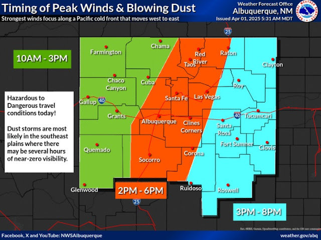
Today's weather across New Mexico will be no joke. Yet another widespread high wind/blowing dust event is slated for the state and area. Every county in New Mexico is under a High Wind Warning or a Wind Advisory through this evening.
Damaging Winds!
Damaging winds are forecast along and east of the central and south-central mountain chains eastward out onto the eastern and southeastern plains. Power poles, power lines, utility lines, trees, small sheds, outbuildings, fences, and roofs may be damaged or blown down in some locations.
In the High Wind Warning areas, southwesterly winds are forecasted to become sustained at 35 to 45 mph with gusts to 60 to 65 mph. Localized higher gusts will be possible. Gusts in the Guadalupe Mountains may reach or exceed 75 mph!
In the Wind Advisory areas, southwesterly winds are forecast to become sustained at 25 to 40 mph with gusts to 50 to 55 mph. Localized higher gusts are possible.
Dust Storm & Brownouts!
Widespread areas of blowing dust will develop across the state later this morning and early afternoon reducing the visibility down to near one mile at times. Localized blinding dust storms will accompany higher wind gusts with sudden drops the visibility down to zero with little to no advanced warning. Brownouts are possible in these areas along with some road and highway closures.
This spring has been the worst we've had in years in parts of the state with multiple damaging/high wind events along with numerous dust storms. There have also been multiple vehicle pileups in the blinding dust storms with injuries and several fatalities.
Please do not stop your vehicles in the middle of roads and highways. Pull over to the side of the road as far as possible. Travel in these areas will become dangerous to life-threatening today so if you can avoid traveling please do so.
Critically Dangerous To Extremely Critically Dangerous Fire Weather Conditions!
Critically Dangerous to Extremely Critically Dangerous Fire Weather Conditions will exist across most of the state and area today, and in some areas again on Wednesday. Any wildfire that may form will have the ability to rapidly spread and grow and may be difficult to impossible to contain or control in the high winds.
Winter Storm Late This Week.
Snow is expected to fall over parts of the higher elevations of the northern mountains today into Wednesday. Some of which may be moderate to heavy at the higher elevations.
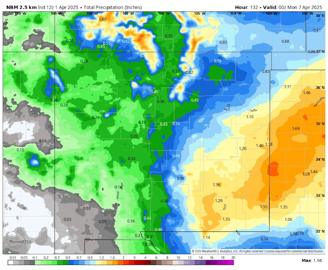
Then Mother Nature goes bipolar on us late this week into the weekend. A winter storm looks to be on track to impact the state with moderate to locally heavy rainfall at some of the lower elevations and moderate to heavy wet snows in the state's mountains generally above 6,000'.
A rain and snow mix may also occur in some of the state's lower elevations. The models continue to hone in on this upcoming winter storm so the exact details haven't been fine-tuned yet. For now, it appears that the mountains may end up with heavy wet snow (generally around 7,000' and above) with some locations getting perhaps a foot or more. This includes the Sacramento and Capitan mountains.
Nothing is set in stone yet as the models continue to refine their forecasts concerning this potential winter storm. So expect changes in our local forecasts with the possibility of Winter Storm Watches/Warnings and Winter Weather Advisories being issued for some areas of the state Friday into the upcoming weekend.
A historic snowstorm hammered southern, south-central, and southeastern New Mexico and parts of West Texas April 4-8, 1983. I've been telling my family and friends that we are due for another similar event here in southeastern New Mexico. So don't be surprised if the white stuff falls on some of us late this week into the weekend.
Link to my blog post about that event:
Historic April 1983 Snowstorm.
Today.
National Blend Of Models (NBM) Storm Total Precipitation Forecast.
Area Forecast Discussion
National Weather Service Midland/Odessa TX
652 AM CDT Tue Apr 1 2025

...New AVIATION...

.KEY MESSAGES...
Updated at 642 AM CDT Tue Apr 1 2025

- Strong winds, blowing dust, and critical fire weather conditions
  will impact southeast New Mexico and much of west Texas today.

- An isolated strong to severe storm cannot be ruled out over the
  eastern and northeastern Permian Basin tonight.

- Rain chances increase late this week and into the weekend.

&&
Area Forecast Discussion...UPDATED
National Weather Service Albuquerque NM
538 AM MDT Tue Apr 1 2025

...New AVIATION...

.KEY MESSAGES...
Updated at 527 AM MDT Tue Apr 1 2025

- Damaging wind gusts, very low visibility in blowing dust, and
  high fire danger are expected across much of the region today,
  with the strongest gusts and most widespread dust focusing in
  eastern New Mexico this afternoon.

- Winds decrease tomorrow, but the risk of rapid fire spread will
  remain elevated in south-central and eastern New Mexico during
  the afternoon.

- A dramatic pattern change brings increased chances for lower
  elevation rain/snow and potentially significant mountain snow
  Friday through the weekend. Confidence is high for widespread
  wetting precipitation and much cooler temperatures.

&&

.SYNOPSIS...
Issued at 225 AM MDT Tue Apr 1 2025

Strong to damaging wind gusts, blowing dust, and high fire danger
will impact much of New Mexico today, with the strongest winds and
greatest risk of fire spread in eastern New Mexico. Several dust
storms are expected, which will create near-zero visibility in dust-
prone areas during this afternoon. Winds decrease Wednesday, but it
will remain breezy with elevated to near-critical fire weather
conditions in south-central and eastern areas. A dramatic pattern
change occurs late week, bringing widespread precipitation and
cooler temperatures. Travel impacts from snow are likely on at least
mountain routes, with impacts potentially extending to I-25 and
I-40, Saturday through early Sunday as snow levels drop.

&&
Area Forecast Discussion
National Weather Service El Paso TX/Santa Teresa NM
604 AM MDT Tue Apr 1 2025

...New AVIATION...

.KEY MESSAGES...
Updated at 538 AM MDT Tue Apr 1 2025

 - Very windy conditions across the area this afternoon will
   create blowing dust in the lowlands and critical fire danger

 - Tomorrow will be breezy with blowing dust and critical fire
   danger

 - Light lowland rain and modest mountain snow chances Friday and
   Saturday

&&
There Are None So Blind As Those Who "Will - Not" To See...107.


I remember April 12, 1980 surprise snowstorm and the April 4th -8th snowstorm of 1983. I long for that but especially the much needed precipitation in this horrendous drought. By the way, El Paso had two years back to back under 5” in 2023, 2024. The only other time that has happened on record was 1910-1911! Praying for precip.
ReplyDelete